


 69 / 336

[
] 69
T
ransboundary
W
ater
M
anagement
while helping to maintain a steady supply of water for downstream
users who are often across borders, especially in the HKH region.
In conclusion, the HKH region holds vast reservoirs of water and
the origins of 10 major river systems. Climate change, directly through
impacts on temperature and precipitation regimes and indirectly
through changes in the cryosphere, is likely to have a serious impact on
the region’s water supply and pose a significant threat to environmental
sustainability and economic development. Regional water cooperation
offers an important mechanism to support natural resource manage-
ment. The ideal of a transboundary river basin organization may not be
envisaged in the immediate future because of the geopolitical realities
and the inherent complexity of coordinating the activities of the various
actors involved in shared water systems. However, important steps can
still be made based on recent global and regional processes and conven-
tions. Development of the regional knowledge base on climate change
impact, green hydropower development, flood risk reduction, early
warning and sharing of information and knowledge provide promising
entry points for fostering water cooperation in the region. Knowledge
hubs such as ICIMOD offer avenues for bringing together commercial,
academic, government and civil society organizations to generate tech-
nically superior schemes, help secure financial resources and facilitate
broader water cooperation.
ICIMOD: fostering regional cooperation on water
The HKH Hydrological Cycle Observation System (HKH-HYCOS)
initiative aims to strengthen hydrometeorological monitoring
capacity and is establishing a regional flood information system
based on state-of-the-art communication and information
dissemination technology to save lives and property in the
region. By early 2013 the project had upgraded 24 real-
time observation networks in four countries (Bangladesh,
Bhutan, Nepal and Pakistan) and established an efficient
data transmission and acquisition system to enable accurate
forecasting and effective early warning in the region.
The Koshi Basin Programme, an example of ICIMOD’s
transboundary river basin approach, promotes cooperation
among China, India and Nepal to maximize benefits such as
irrigation and hydropower while minimizing adverse events such
as floods and landslides. The programme fosters interaction
and reconciliation of the interests of the various actors at the
basin scale. Its approach to river basin management integrates
scientific, economic, social and ecological knowledge to support
policy and decision-making to promote the sustainable use of
transboundary water resources and develop ‘win-win’ solutions
that can be supported by all three countries. Particular focus is
given to issues of gender and inequality and their linkages to
drivers of change and river basin management, as well as to the
potential of employing incentive-based mechanisms to improve
water use efficiency and productivity.
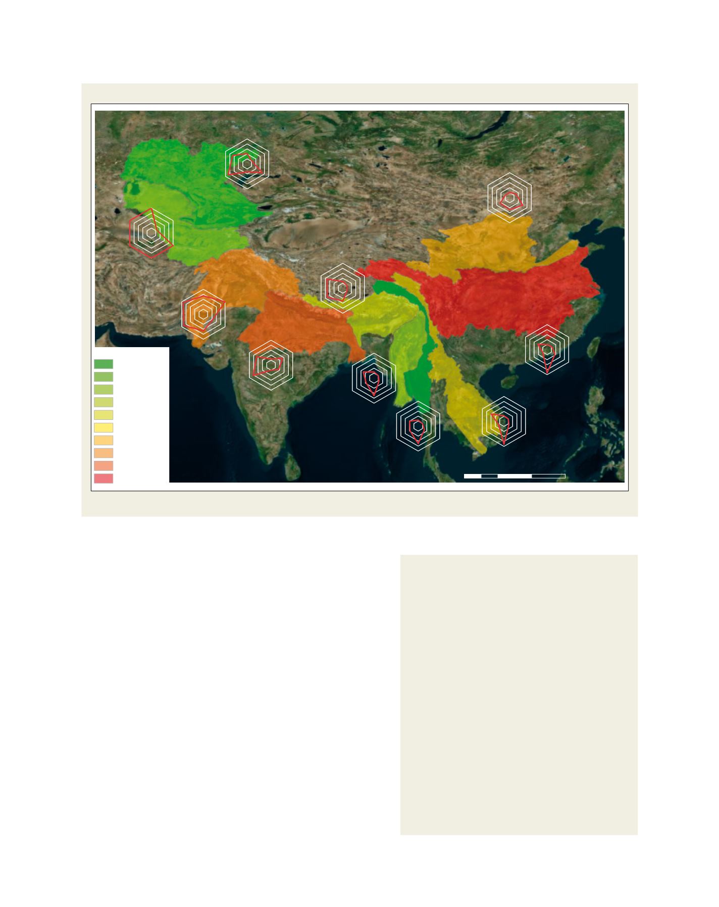
Susceptibility of 10 river basins of the HKH region to water scarcity and potential adaptation strategies
Potential causes for future scarcity
DG = dependence on glacier melt
GD = groundwater depletion
RP = reservoir potential
FP = future precipitation
ED = projected economic development in terms
of GDP and population growth
Yangtze (YA)
Indus (IN)
Yellow (YE)
Syr Darya (SD)
Ganges (GA)
Amu Darya (AD)
Mekong (ME)
Brahmaputra (BR)
Irrawaddy (IR)
Salween (SA)
Population (million)
< 14
15 - 23
24 - 25
26 - 41
42 - 51
52 - 70
71 - 162
163 - 203
204 - 432
433 - 601
DG
GD
RP
FP
UP
ED
DG
GD
RP
FP
UP
ED
DG
GD
RP
FP
UP
ED
DG
GD
RP
FP
UP
ED
DG
GD
RP
FP
UP
ED
DG
GD
RP
FP
UP
ED
DG
GD
RP
FP
UP
ED
DG
GD
RP
FP
UP
ED
DG
GD
RP
FP
UP
ED
DG
GD
RP
FP
UP
ED
´
0
500 1,000 1,500
250
Kilometres
Source: By permission fromMacmillan Publishers Ltd: Nature Geoscience (Immerzeel WW, Bierkens MFP (2012) Asia’s water balance. Nature Geoscience 5:841-842), © 2012
Radar charts show qualitative ranking between low susceptibility and/or large coping capacity (1) and high susceptibility and/or small coping capacity (5).