


 89 / 336

[
] 89
T
ransboundary
W
ater
M
anagement
groundwater resources have decreased due to a falling
groundwater recharge rate in the Kumamoto region.
The major reason for this decreasing groundwater
recharge rate is considered to be land use change in
the past 30 years due to rapid urbanization.
In the Kumamoto region, sources of groundwater
recharge to the reservoir are mainly attributed to the
surrounding mountain regions, forests, grasslands and
paddy fields. Among them, the groundwater recharge
rate from the paddy fields is estimated at about 46
per cent annually.
5
Therefore, the most effective
measure to increase groundwater in the region is to
use the paddy fields through collaboration with local
farmers. In this regard, the Kumamoto Prefecture and
Kumamoto City have created a unique funding system
to encourage artificial groundwater recharge projects
through abandoned paddy fields in neighbouring
towns outside Kumamoto City, for the sustainable use
and management of regional groundwater resources
and the preservation of this precious resource for
future generations.
A Conference on Utilizing Rice Paddies for
Groundwater Recharge consisting of the Kumamoto
Prefecture, Kumamoto City, two relevant local
governments, four land improving districts and Japan
Agricultural Cooperatives (JA) was established in
2004 to promote the funding system for implementing
the artificial groundwater recharge project through
the abandoned rice paddy fields. This groundwater
management system is regulated by the Kumamoto
stores major groundwater resources in the Kumamoto region and
is developed for water resources as a huge groundwater reservoir
which has relatively high local precipitation of around 2,200 mm
per year and highly permeable pyroclastic deposits.
In a geologically unique area called the groundwater pool, a lacus-
trine deposit layer separating the two aquifers allows rainwater and
irrigation water to recharge directly into the No. 2 aquifer system.
1
The groundwater recharged in this area flows toward to the south-
west, flowing out into the lake of Ezu and many other locations in
Kumamoto City. The groundwater supplies 100 per cent of the water
for the 670,000 residents of Kumamoto City, which is a prefectural
government. In this regard, the No. 2 aquifer in the Kumamoto
region is a transboundary aquifer crossing regional administrative
boundaries. This is a typical feature in transboundary aquifer distri-
bution observed in many other Japanese provinces.
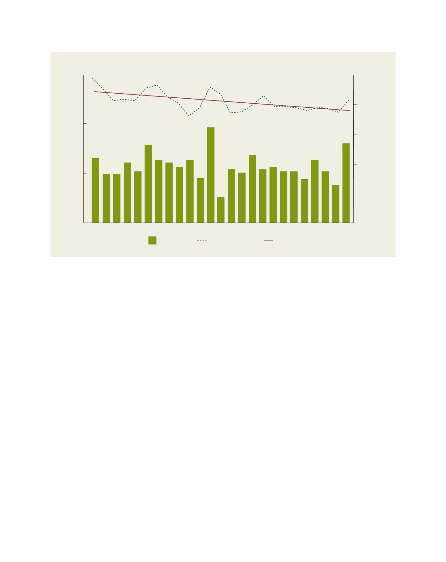
Kumamoto City started to measure groundwater levels in the
1980s through a network of observation wells. In the 25 years
between 1982 and 2006, the groundwater level declined 4.4 m,
an average decline of 0.18 m/year. This trend of groundwater
level decline is also observed in the other 12 observation wells
located in the upland area of the region.
2
The discharge of spring
water in the representative spring lake of Ezu has also dimin-
ished by approximately 15 per cent during the last 15 years from
450,000 m
3
/day to 380,000 m
3
/day. In the 1950s, it was approxi-
mately 1 million m
3
/day.
3
On the other hand, total withdrawals
of groundwater in the region have been reduced, mainly due to
a considerable decrease in groundwater extraction for industrial
and agricultural uses. The amount of city water supplied is almost
constant, and now accounts for more than 60 per cent of total
groundwater consumption.
4
These facts indicate that the region’s
Annual change of groundwater level in the observation well at Kikuyo
Source: T. Tanaka
0
30
10
20
0
5000
4000
Groundwater level altitude (m)
Annual rainfall (mm)
1982
1988
1994
2000
2006
3000
2000
1000
Annual rainfall
Monthly average level
Trend