
12
|
By Design
hole pretty easily and even put it out on YouTube so the
club can share it with their entire membership. It’s a
selling point, showing people what is going to happen
and getting them excited about the project.”
Benkusky had seen some impressive animation work
for another project and wondered if he could emulate it
with video for a project he was working on at St Charles
Country Club in St Charles, Illinois. “I decided to
experiment with a couple of holes last fall,” he explains. “I
was just playing around with it, but it ended up looking
great.” Benkusky took drone video footage and then
overlaid it with proposed alterations and annotation (see
sidebar). “You do some stop-frame work, exporting a
snapshot image out to Photoshop for manipulation, insert
in back in and add in some transitioning,” he explains. “I
sent it over to the superintendent and he shared it with
the club, they said ‘how about we do all eighteen holes!”
George agrees. “Clients love presentation video—
whether it’s architectural or the club just wants flyovers to
be on their website.
Getting information faster
“But we’re just at the tip of the iceberg. One of the main
applications is getting information faster,” he adds. “In a
similar way to when CAD was introduced and we could
make changes to designs in minutes rather than hours,
drones have the capability to gather information in hours
rather than weeks.”
Specifically, by using a drone in combination with
photogrammetry software, architects can get accurate and
detailed topographical information for a site in a fraction
of the time it would take to do a traditional land survey.
Vestavia recently conducted an entire survey of the
property. “They went out with a drone and programmed
it to fly back and forth,” says George. “It went up for 45
minutes, came down and they replaced the battery and
flew it again. It’s as good a topo as I’ve ever had and it
took them two hours instead of two weeks.”
“To be able to go out with the drone and within minutes
set up a small flight plan and get the sort of base material
I need is invaluable,” says Cervone. “It’s an expensive
proposition to get someone out to do topo for you—and
not to mention you are then on their time. I can go out on
my own and turn something around in the same day.”
A number of software applications are available for download
to a smartphone or tablet, which connect with the drone and
enable the user to set up an automated flight plan and capture
the images required to produce a topographic map.
“Once you get the hang of setting up a flight plan,
which is simple to do, you hit a button, that drone will
take off, fly what you set up on that app, come back and
land at your feet,” says Cervone. “The aerial images are
taken by the camera and stitched together into an overall
larger aerial, and through photogrammetry the software
that I’m using creates the topographic information.”
The accuracy is impressive too, according to Cervone.
“Typical grading plans may provide two-foot contour
DRONE TECHNOLOGY
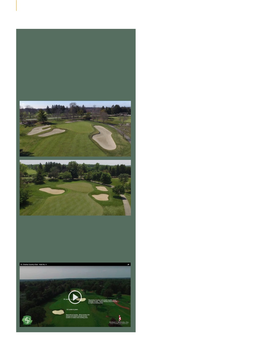
The elevated perspective of images taken by a camera
attached to a drone provides a different perspective from
on-the-ground shots. In the example below, before and after
images taken from the air provide a complete picture of the
impact of bunker reduction around the eleventh green at St
Charles CC, including the removal of a bunker behind the
green. Mike Benkusky, ASGCA, explains: “From the air you
get a much better scale of the bunkers. This helps to show
that we can minimize sand area to improve playability and
maintenance, yet still keep the strategy of the golf hole.”
Video visualization
With some stop-frame work and annotation, video footage of
entire holes can be manipulated to show proposed changes.
See videos of St Charles CC at:
www.youtube.com/watch?v=1c0wUWZjXtUand
www.youtube.com/watch?v=mp2eENQWfPIA clear perspective
Before
After


