


 13 / 24

13
lines and you interpolate everything
between it. When I’m designing a golf
green I am usually proposing six-inch
contours. With a drone I can get a
one-inch contour map. For projects
where we are rebuilding greens, in
many cases they want to restore the
green back to its original condition.
For example, this summer I will
be rebuilding the putting surfaces
at Sewickley Heights Golf Club in
Sewickley, Pennsylvania. They have
asked me to improve the number of
pin placements, but want to retain
the original character of the greens.
So having tight topos you can go back
and get everything you want.”
At Vernango Valley Golf Course
in Venango, Pennsylvania, close
to where Cervone grew up, the
club didn’t have a topographic
map. Cervone has used the drone
numerous times to quickly and easily
get the information he needs.
“Recently, we needed to address
are some drainage issues around a
particular green complex. I can go out
and shoot this green complex and get
the contour information I need. I will
know where I can hit my low points
and how we need to reshape the area
to create the fall. It’s so much easier to
work out where I want my first inlet,
where the next swale should go. It
makes the process more efficient.”
The club also has a stockpile of
material to use for shaping work.
Cervone says: “With the drone I can
actually fly over that stockpile and
create the topo and quickly do a
volumetric calculation based on the
aerial. I’ll then know exactly how
much we have to work with.”
Future possibilities
In future, Cervone plans to spend
more time investigating 3D modeling
capabilities. “It can take a 3D model
that you can look at, turn and flip as if
it were that picture made out of clay,”
he says. “We are always struggling
graphically to get our proposed designs
across to the layman. With this new
technology now we can actually take a
3D model that everyone understands
and show that to them so they can get
a better picture in their minds of what
the eventual design will look like—
that’s what I’m after.”
If the enthusiasm with which ‘early
adopter’ golf architects have for
drones is anything to go by, it seems
that the technology is here to stay.
“I’ve done a lot of aerial photography
study and a lot of land terrain
analysis,” says George, who previously
served in the U.S. Army. “I’ve been
around it and understand it—it’s so
visual, so much clearer with these
things that I think it brings a whole
new level into terrain analysis.”
“I think it’s boundless.”
•
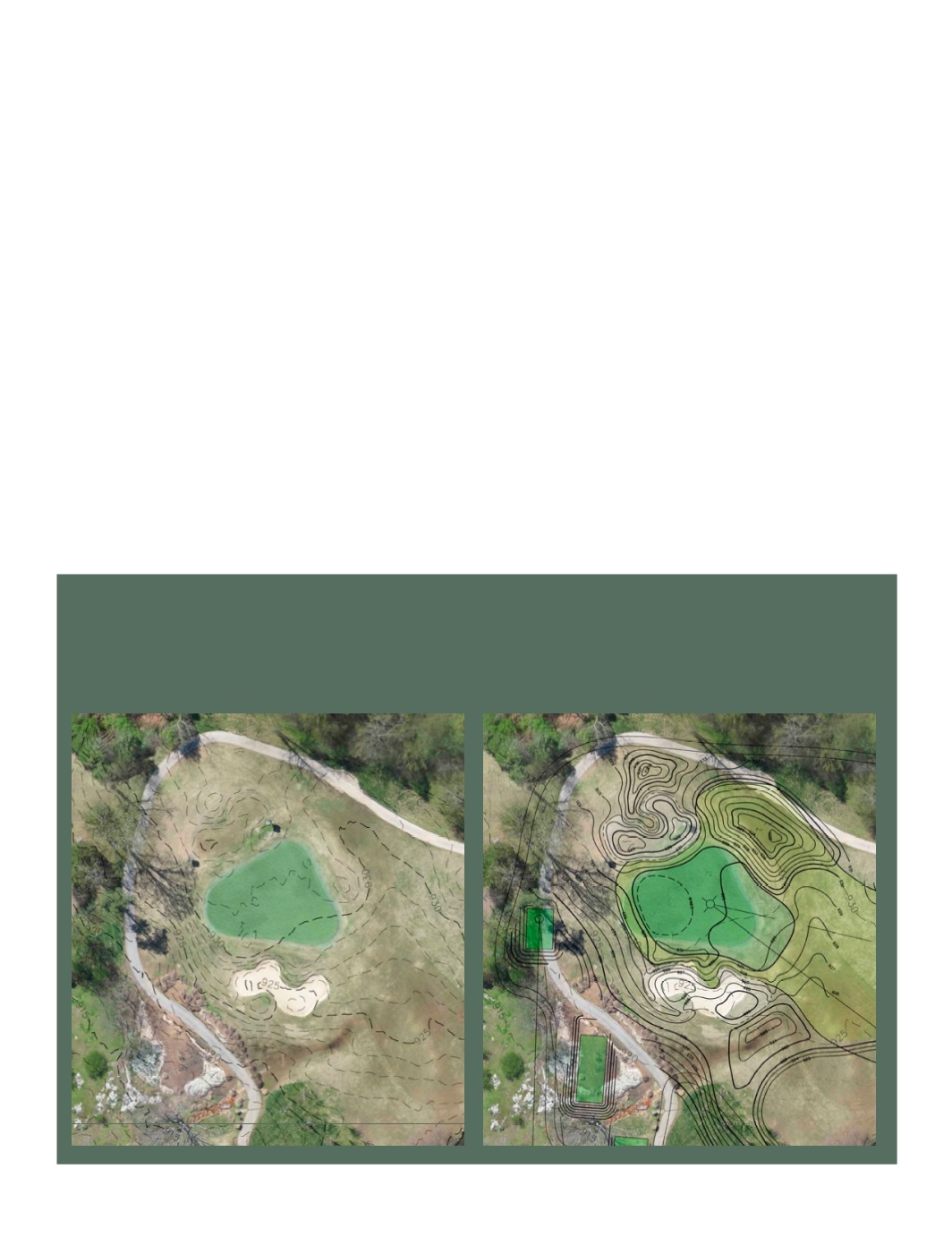
Combining a drone and camera with photogrammetry software
enables architects to quickly and easily produce detailed
topographic maps with contour lines, which can then provide the
basis for design decisions and grading plans.
The below images from Vestavia CC show existing conditions
(left) and proposed plans. “You can clearly see the detail in the
existing conditions which allows us to formulate all future plans
and calculations,” says Lester George, ASGCA.
Topographic maps