


 212 / 336

[
] 212
W
ater
C
ooperation
, S
ustainability
and
P
overty
E
radication
deterioration. In addition, the lack of cross-border
cooperation makes it difficult to assess hydrologi-
cal measures. This often leads to conflicts at different
levels, whether between the adjacent inhabitants or
between governments. There is an urgent need for
bilateral agreements to join assessments between the
neighbouring regions, in order to reach a comprehen-
sive figure on water resources and a hydrological regime
for effective water use.
There are about 215 international rivers and 300
groundwater basins that are shared by two or more
countries.
4
However, transboundary water resources
have many different aspects and a wide range of scales.
Normally, aquifers and rivers are the only hydrologi-
cal components considered as shared water resources.
However, other components, such as streams and
springs, are also important and must be included in
hydrological investigation.
are still ignored and subjected to exhaustion – particularly
the Al-Kabir River in the north and the El-Wazzani River in
the south. To date, however, there has been no credible study
to assess and allocate the transboundary water resources that
Lebanon shares with neighbouring countries. Consequently,
geopolitical conflicts frequently exist due to the obscure nature
of the hydrological conditions.
There follows an assessment of the principal hydrological aspects
of Lebanon’s transboundary water resources, including quantitative
measures and geospatial delineations. This can be used as first-hand
information to highlight the urgent need for effective cooperation at
local, regional and international levels upon which bilateral agree-
ments can be established.
Lebanon is characterized by two adjacent mountain ranges which
are separated by the Bekaa plain. The three units trend north-
north-east to south-south-west. The rock succession of Lebanon is
well-defined by carbonate rocks (mainly limestone) building up the
largest part of the stratigraphic column.
1
The existence of elevated mountain ranges, especially those
facing the Mediterranean, has created a climatic barrier that
receives cold air masses from the west, resulting in a high precipi-
tation rate which reaches up to 1,500 mm per year. This makes
Lebanon a water-rich country, once described as ‘the water tower
of the Middle East’. It is a unique region in the Middle East where
snow cover remains for a couple of months on the mountain
crests, occupying about 2,500 km
2
. In addition, there are more
than 2,000 major springs, with discharge exceeding 10 litres per
second, and around 60 major submarine springs issue offshore.
2
Lebanon is also well known for its karstic cavities, which consti-
tute a major source of groundwater.
Recently, Lebanon became a country under water stress,
notably in the context of climatic variability and population
growth. There has been an obvious volumetric decrease in the
available water resources in the last few decades, estimated at an
average of 40 per cent.
3
Even though Lebanon has a small land area (around 10,400 km
2
),
a large part of its water resources is shared with neighbouring coun-
tries. Hence, out of the 882 km border perimeter, approximately 559
km (63 per cent) is shared with Syria in the north and east; and 98
km (11 per cent) with is shared with other countries in the south
and partly to the east. The other 225 km faces the Mediterranean
Sea. In several localities, however, geographical landmarks such as
mountains and valleys often coincide with political borders between
the three countries. There is an obvious lack of joint implementa-
tions to conserve water resources that extend between these regions,
and this in turn results in many aspects of water loss and quality
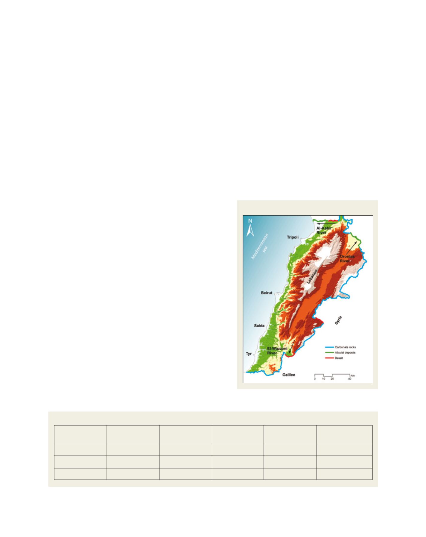
Lebanon’s border, topography and border rocks
Source: National Council of Scientific Research (CNRS), Lebanon
River
Al-Kabir
El-Assi
El-Wazzani
Length
(in Lebanon)
60 km
65 km
75 km
Catchment area
(in Lebanon)
295 km
2
1,900 km
2
625 km
2
Origin
Shared
Lebanon
Lebanon
Major exploitation
65% Syria
Syria, Turkey
PT
To
Mediterranean
Syria, Turkey
PT
Fundamental characterizations of Lebanon’s shared rivers
Source: National Council of Scientific Research (CNRS), Lebanon