


 216 / 336

[
] 216
W
ater
C
ooperation
, S
ustainability
and
P
overty
E
radication
The main challenge of using saline and brackish
water in agricultural production is to develop sustain-
able and economical production systems for marginal
areas through:
• selecting appropriate plant species
• identifying saline and brackish water resources
• identifying available land resources for the
application of biosaline agriculture
• developing appropriate soil salinity management
practices
• developing irrigation and leaching practices that can
maintain root-zone salinity at acceptable levels
• evaluating applicable production systems
• monitoring livestock production (in the case of
forage production systems).
Managing land and water resources effectively and
efficiently requires increasing the diversity of crops
produced. Many conventional crops are generally not
salt-tolerant compared with forages, and most forage
production systems consume large amounts of fresh
water per unit of dry matter produced. Moreover,
forage production is often insufficient to meet the
demands of an increasing livestock population, which
leads to increasing pressure on natural rangeland
resources and contributes to land degradation and
desertification. By using crops that not only tolerate
but thrive in saline conditions and produce economic
yields, the whole landscape can be changed for poor
farmers, leading to improved food security and poverty
alleviation. Therefore the development of production
systems that use saline water in salt-affected envi-
ronments addresses several important economic and
environmental constraints.
Cooperation at local, national, regional and interna-
tional levels is crucial in managing the often competing
interests between different users of water and land.
However, cooperation and integration between local
knowledge, advances in science (research) and policies
(laws and budgets) is still fragmented, especially in under-
developed countries. The linkages between the technical
experts, local stakeholders and decision makers are key
factors for successful decision-making related to water.
Increased levels of cooperation have led to increased
demands for information on which to make sound
decisions. It is important to generate data, model-
ling and tools, including geographic information
system technology and remote sensing, in order
to obtain sound characterization and for land and
water management planning. Unfortunately, most of
the international databases have been developed for
good quality water and arable lands, and hence no
comprehensive and reliable information is available
for marginal environments.
In developing countries many organizations have
water resources data, but it is often fragmented and
located in the files and on the shelves of separate
ministries, departments, institutions, libraries and
universities. The lack of centralized basic information
future changes in climate in the dry regions. Rainfall (greenwa-
ter) is scarce and surface water and groundwater (bluewater) are
already heavily exploited. Rivers are limited to a few countries
within the region and the downstream areas, such as the Nile
Delta in Egypt and the lower Tigris/Euphrates in Iraq, are suffer-
ing from increasing salinity and/or reduced flows. Much of the
groundwater in other countries has very limited natural recharge
and is being overused, resulting in declining levels (with increased
pumping energy required to use it) and increased salinity. Part of
the solution is to explore other water sources, crops with low water
requirement, higher water productivity and appropriate policies.
A total of 2.6 billion km
3
of usable (3,000-16,000 parts per
million) brackish water per year is available to potentially irrigate
about 332,000 ha of land in six of the MENA countries through
‘biosaline agriculture’.
1
Substituting saline or wastewater resources
for fresh water used in agriculture (for many agricultural commodi-
ties) can free the fresh water for other essential sectors to improve
health, sustainability and poverty reduction.
Case study: MAWRED
Groundwater resources are under increasing pressure in the MENA
region and declining levels in many aquifers highlight the need for careful
future management. Given the growing need for water in many economic
sectors, decision makers need to understand current resource limits
and the impacts of future conditions as they develop policies balancing
demands. The provision of timely data is an important input into this
process, but in many MENA countries such information is limited.
The MAWRED (Modeling and Monitoring Agriculture and Water Resources
Development) programme, through dynamic modelling and space-based
observations, is developing new country-level (Tunisia, Iraq and Yemen)
and regional data sets to support evidence-based policy development and
decision-making in the MENA region. This programme is funded by the
United States Agency for International Development and is in partnership
with the National Aeronautics and Space Administration. Data development
falls under four main groups:
• Climate variability – seasonal forecasting (3-6 months) and
dynamically downscaled long-term (20 year periods over 100 years)
climate change
• Water resources – current and future ground and soil water and
evapotranspiration balance
• Agriculture – current land cover, crop group and irrigation maps; key
crop yield estimates under current and future climatic conditions;
irrigation use water balances
• Drought monitoring – estimates of hydrological and agricultural drought.
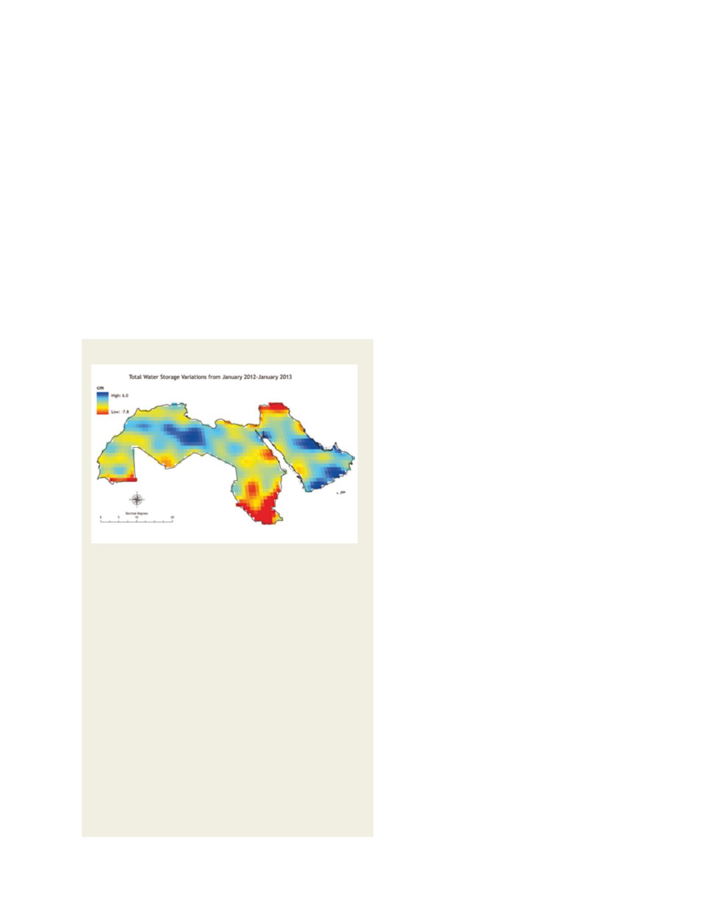
The water storage variations, 2012-2013: timely data is needed to
understand resource limits and the impacts of future conditions
Image: ICBA