


 220 / 336

[
] 220
W
ater
C
ooperation
, S
ustainability
and
P
overty
E
radication
edge-based approach to bridging yield gaps with a mission-mode
initiative, forming a consortium and a network for stakeholders to
share their knowledge about the weather, soil health and improved
management practices across all 30 districts in the state. The
overwhelming impact has strengthened the partnership between
ICRISAT and the GoK, and eight major Consultative Group on
International Agricultural Research (CGIAR) centres have been
invited, along with AVRDC (the World Vegetable Center), to work
towards improving rural livelihood systems in four benchmark
districts representing different agroecological zones in the state.
Up-scaling the benefits of integrated watershed management
necessitates an articulated strategy based on the main pillar of
capacity building of all stakeholders, including farmers, research-
ers, development workers, policymakers and development investors.
New scientific tools such as remote sensing, geographical informa-
tion systems and crop simulation modelling for the analysis of
long-term potential productivity, need to be used as the planning
tools. These tools provide the capabilities for extrapolating and
implementing the technologies to other larger watersheds.
The ICRISAT consortium focused on training farmers, personnel
from development agencies and NGOs through demonstrations of
different technologies on benchmark watersheds, and acts as a mentor
for technology backstopping. The farmers’ community, through
village institutions, took responsibility for all activities of implemen-
tation and monitoring. Government and non-governmental agencies
catalyzed the process. The important aspect while evaluating and
scaling-out this approach is that the relevant government line depart-
ments must be included in the consortium along with other partners.
The role of policymakers and development investors is critical, and
sensitization of these stakeholders played a major role in
scaling-out the benefits in Asia.
Impacts and outcomes
An innovative integrated watershed management model
developed by ICRISAT and its partners produced a wide
range of impacts. Close monitoring of groundwater
resources in different watersheds in India confirmed
that water harvesting structures sustained good ground-
water yield even after the rainy season. For instance, in
the Lalatora watershed in Madhya Pradesh, the ground-
water level in the treated area registered an average
rise of 7.3 metres; at Bundi watershed in Rajasthan a
5.7 metre increase was observed, and at the Adarsha
watershed, Kothapally in Andhra Pradesh, a 4.2 metre
rise in groundwater was recorded. In Adarsha water-
shed, a study showed that nearly 60 per cent of the
run-off water was harvested through agricultural
water management interventions which also recharged
shallow aquifers. Water harvesting structures (WHS)
resulted in a total 6 metre rise in the water table during
the monsoon. At the field scale, WHS recharged open
wells at a 200 to 400 metre spatial scale.
11
The various
WHS resulted in an average contribution of seasonal
rainfall to groundwater during the normal rainfall year
of 27-34 per cent in Rajasamadhiyala and Shekta water-
sheds.
12
In the Adarsha watershed, due to additional
groundwater recharge, a total of 200 ha were irrigated
in the kharif (autumn) season and 100 ha in the rabi
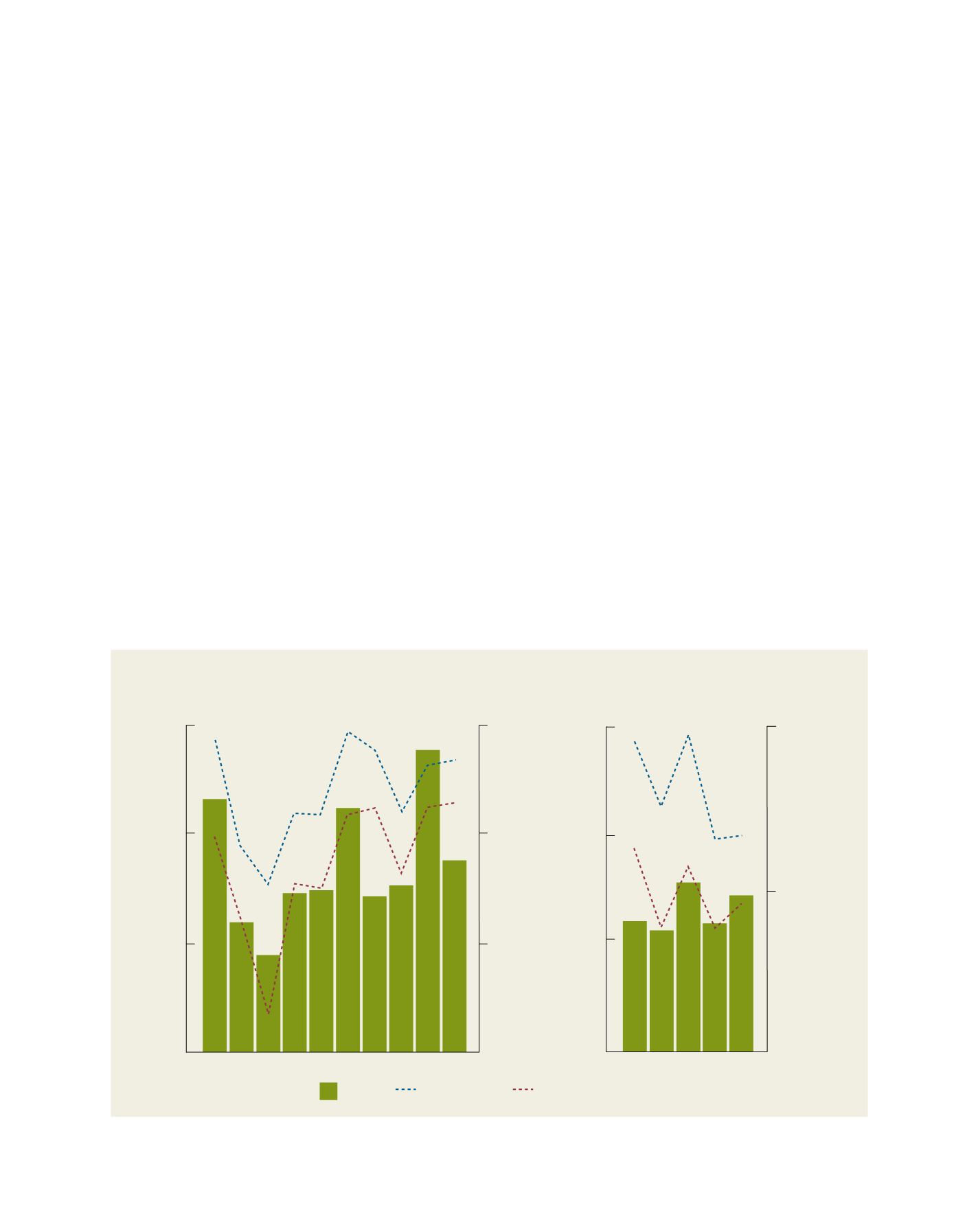
Rainfall
Near check dam
Adrasha watershed, Andhra Pradesh
Bundi watershed, Rajasthan
18
0
12
6
Waterlevel in well (m)
Rainfall (mm)
Rainfall (mm)
0
1500
500
1000
Away from check dam
2000
2003
2006
2009
18
12
6
0
Waterlevel in well (m)
0
500
1000
2002 2004 2006
Mean annual groundwater levels in wells as influenced by the water harvesting structures at Kothapally and Bundi watersheds
Source: Wani et al., 2010