


 44 / 192

[
] 44
Sustainable land management in Mongolia
Bayarbat Dashzeveg, Ministry of Environment, Green Development and Tourism of Mongolia
M
ongolia is one of biggest inland countries in
Asia with an area of 156.65 km
2
, most of which
is arid and semi-arid land. It lies at a fairly
high elevation (approximately 1,580 m) above sea level,
completely separated from oceans and seas (500 km from
the Atlantic Ocean, 1,600 km from the Yellow Sea) and
surrounded by high mountain ranges. It borders on China
in the east, west and south and on Russia in the north.
According to the definition provided in the United Nations
Convention to Combat Desertification (UNCCD), 90 per
cent of Mongolia’s landmass is highly vulnerable to deser-
tification and land degradation.
Mongolia has a typical continental climate and average
temperature of 1.56a. The lowest temperature is -50
0
C in
winter and in the Gobi area the highest temperature can
reach 40
0
C. The topography of the land largely influences the
geographical distribution of climate characteristics, and is to
some degree reflected in the soil and vegetative cover proper-
ties where it has created a distinctive distribution pattern. On
the other hand, Mongolia has one of the region’s most arid
climates and its ratio of precipitation to evapotranspiration
fluctuates in most territories between 0.05 and 0.65, therefore
it is highly vulnerable to desertification.
The main characteristics of Mongolia’s climate are its distinc-
tive four seasons, high fluctuations in air temperature, low
precipitation, and notable climate differences in latitude and
altitude zones. Results from continuous studies based on offi-
cial data from the National Meteorological and Hydrological
Observation Network demonstrate that the mean annual air
temperature in the Altai, Khangai, Khentii and Khovsgol moun-
tainous regions is colder than 40
0
C, while the valleys between
mountains and major river valleys are colder than 6-8
0
C, the
desert steppe zone is warmer than 2
0
C, and southern Gobi is
warmer than 6
0
C. The mean annual air temperature corre-
sponds with the northern edge of Mongolia’s desert steppe
zone, at latitude approximately 46° north. Permafrost occurs at
territories with a mean annual air temperature lower than -2
0
C.
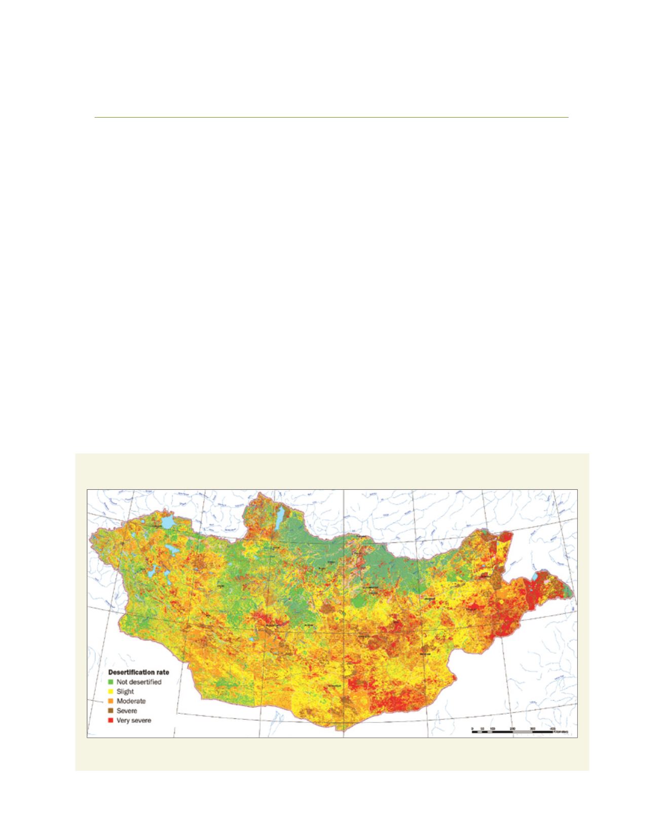
Desertification rates in Mongolia
Source: Min. Env. Mongolia
L
iving
L
and