


 80 / 280

[
] 80
issues. It is building the framework and partnerships for
housing integrated, updated and accessible global biodi-
versity, ecology and geophysical data for use by the
scientific and conservation community. Its work toward
the GEO Biodiversity Observation Network includes,
for example, the distribution of data and results from
the Millennium Ecosystem Assessment. Likewise, the
USGS, NBII, and other governmental and non-govern-
mental institutions are pursuing: (1) development of
web-enabled capabilities (tools) to improve the effi-
ciency of digital data input and resulting accuracies; (2)
Integration and improved accessibility of key global data
sets; (3) Creation of long-term data sharing and analy-
sis partnerships with leading international biodiversity
and ecological informatics and conservation organiza-
tions.
For this purpose, various global biodiversity and asso-
ciated geophysical datasets are being created. Combined
datasets allow for the creation and analysis of valued-
added products and analyses. The following tools are
being developed, tested, and deployed:
• The Global Integrated Trends Analysis Network
(GITAN) is developing a Global Data Toolset
(GDT)
2
which is an operational and easy-to-use
online polygon data entry tool to facilitate an orga-
nization’s ability to engage its network in the entry
and/or validation of digital data (e.g. protected
areas, species distributions, Important Bird Areas).
Network places great emphasis on the establishment of a shared but
distributed architecture of data provision, processing and delivery
of information open to everyone. For example, we envision that each
partner institution will form a data node within the network, so that
each node may share its individual databases with the network to
the extent the partner wishes.
Toward these goals, several demonstration projects are currently
being developed on biodiversity and climate change, protected
areas characterization and monitoring, the use of geospatial data
to improve threatened and endangered species assessments, and a
monitoring system for invasive species. For example, one of the
network partners, the Ecological Forecasting Program at NASA,
is developing the Ecological Model Web, which is an open-ended
system to improve ecological forecasting abilities. The Model Web
brings together various computer models and databases dealing
with a broad scope of physical, chemical, biological and ecologi-
cal processes and making them interoperable via a distributed
network of web services. Model interoperability is often limited
by both technical and non-technical barriers, thus severely limit-
ing their potential uses and users. Following the GEOSS
architecture, the Model Web will try to remove such barriers so
that global access to sophisticated ecological modelling and fore-
casting becomes a reality. A demonstration system is currently
being developed that will test the viability of the concept as well
as provide a core onto which further components can be added.
In a similar vein, the World Data Center for Biodiversity and
Ecology (WDCBE)
1
is supporting the data and information require-
ments for some of the world’s global biodiversity and ecological
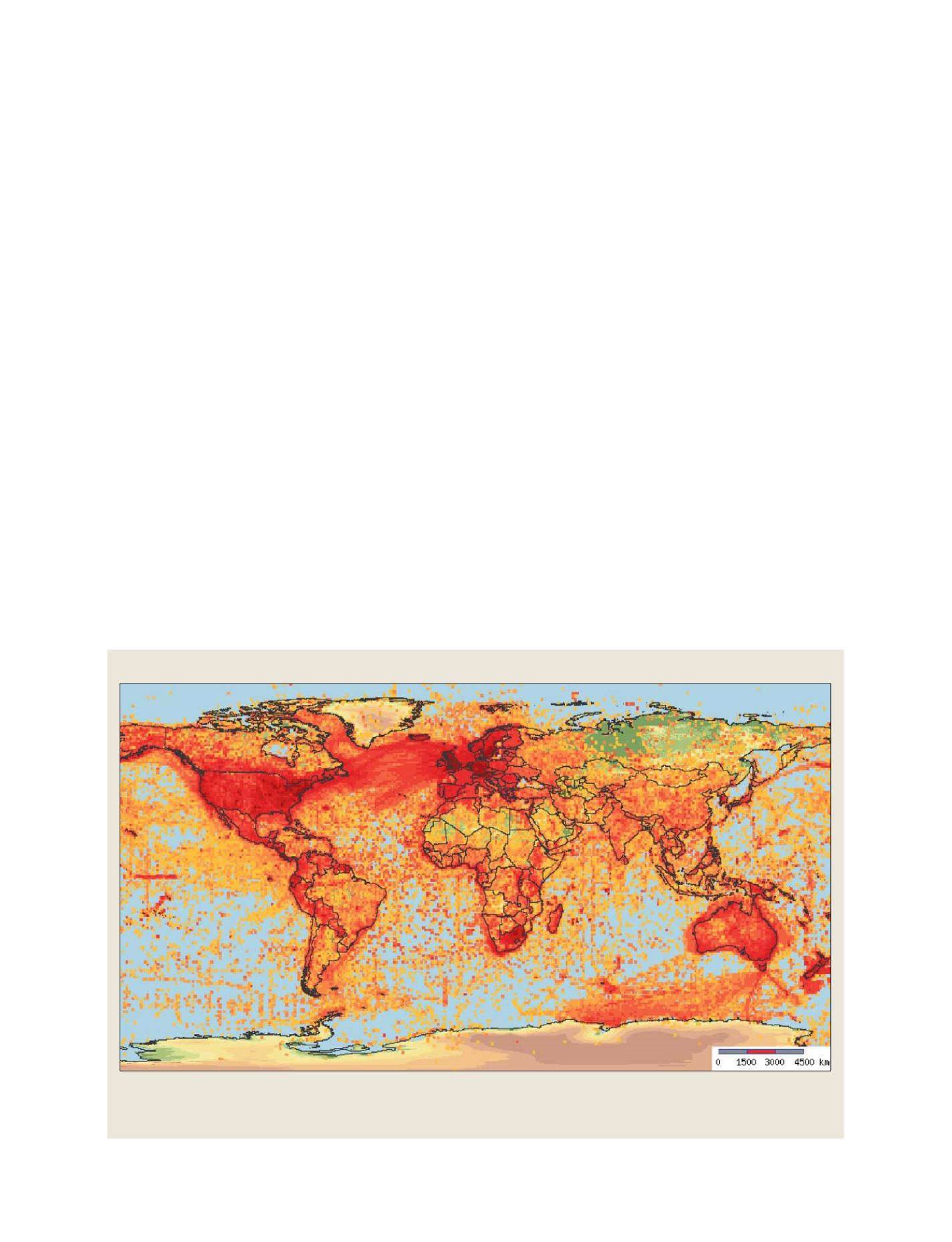
Geographic distribution of density of species occurrence records
The Global Biodiversity Information Facility (GBIF) currently mediates approximately 135 million records of species occurrences through its data portal
(http://data.gbif.org). Such historical biodiversity data is needed in many fields of biodiversity research, for example, in establishing baselines for
measurement and monitoring of biodiversity change
GEOSS C
OMPONENTS
– O
BSERVING
S
YSTEMS