


 158 / 288

[
] 159
D
isaster
R
isk
R
eduction
develop an insurance against water deficit and achieve reinsurance
from an international insurance company.
The development of the insurance involved a second step: the
calibration and validation of the parameters of the hydrological
model over the period 1981-2010. Here, historic daily rainfall data
and average monthly evapo-transpiration of the basins was used.
DNM, INMET and the Joint Technical Commission of Salto
Grande (URU-ARG) provide daily fields of precipitation over the
basins of the Uruguay and Negro rivers. Homogenization of the
data had to occur across the borders, as data from two different
meteorological services were used.
UTE provides the analysis and calculations for rainfall-flow trans-
formation on these basins in order to estimate using a hydrological
model and the expected inflow to Salto Grande (Uruguay-Argentina),
Gabriel Terra and Constitución (Uruguay) hydroelectric reservoirs.
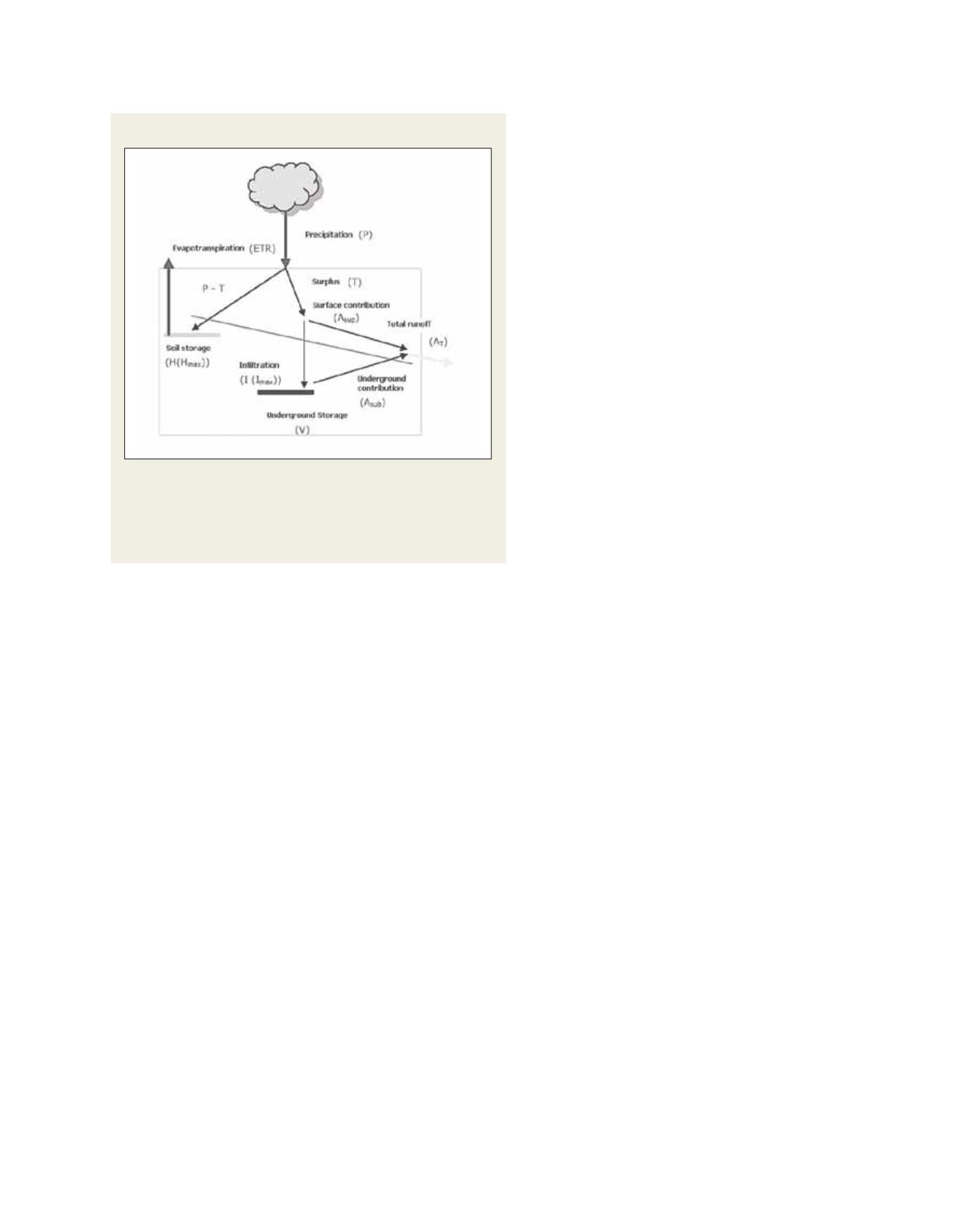
The hydrological model proposed is the Temez model. This is
a model of four parameters, expressed in an aggregated format
over the Thiessen polygons of each rain gauge, since it works with
average values of variables and parameters and reproduced in a
simple and conceptual hydrological cycle in monthly steps. The
model considers two layers, essentially representing the upper
unsaturated zone and the lower saturated zone. These two layers
can be considered as storages, generating fast and slow surface
flows respectively.
Monthly precipitation in a rain gauge used in the Temez model
is time–displaced, to take into account the delay of the flow from
the rain gauge out of the basin. The total inflow of a basin is then
calculated as a sum of the flow derived of the Thiessen polygons
of each rain gauge in the basin. With the estimated total inflow in
each basin in a semester, the UPHEI can be calculated.
The insurance was defined in terms of the values
of UPHEI in the semester. If the estimated UPHEI is
smaller than a defined trigger, a corresponding payment
will be made; otherwise the payment is null.
In a third stage, during the operational phase, the
insurance company requires semi-annual forecasts of
monthly discharges in the basins. Daily rainfall records
of selected stations, at the end of each month during the
operation, will be used as input for the hydro-electrical
model. DNM has established a standardized rainfall
index (SPI) which will define the occurrence of drought
events. The SPI is an index based on the probability
of recording a given amount of precipitation, and the
probabilities are standardized so that an index of zero
indicates the median precipitation amount (half of the
historical precipitation amounts are below the median
and half are above it). The index is negative for drought,
and positive for wet conditions. As the dry or wet condi-
tions become more severe, the index becomes more
negative or positive. The SPI is computed for several
time scales ranging from one month to 12 months,
to capture the various scales of both short-term and
long-term drought. Inferences of shortcomings in the
upcoming six months can then be made in advance and
preparatory measures can be taken. At the same time the
insurance company can prepare for potential payments.
The insurance will work in a pilot phase until 2016.
An extension will then be considered depending on the
successful implementation of the system.
Ongoing provision
The provision of this service requires the combina-
tion of the capabilities of at least four institutions:
DNM, INMET, URU-ARG and UTE. For the effec-
tive and timely delivery of this service by DNM, the
hydrometeorological database (in operation since
2010) was widely used. A team of external engineers
and programmers supported this database. As well as
developing an effective and easy-to-use maintenance
system, they also expanded the data extraction, trans-
formation and processing routines of the available
rainfall information. Financing for this team came
from state resources transferred to the Dirección
Nacional de Meteorología.
Future goals for the service include improving the
availability of rainfall data in the basins under study,
by incorporating automatic stations and satellite rain-
fall estimation. New automatic pluviometer stations
have been acquired in the Negro River basin by UTE,
and URU-ARG has also acquired new rainfall stations
for the Rio Cuareim basin. DNM plans to address the
installation of automatic stations in cities such as Salto,
Rivera and Bella Union.
In future, the service could be expanded to include
other countries and other sub-basins of the Rio de la
Plata basin. An extensive cost-benefit analysis is being
conducted by the insurance company which will
provide insight on the economic value of providing
this climate service.
Source: UTE (Uruguay)
The Temez conceptual model: A surplus (T) part of the water which
precipitates (P), is infiltrated (I) to the second layer, and goes to the
stream-flow (Asup), whiles the rest of this water (P) is stored in the first
layer of soil. Here, evapotranspiration occurs and the soil may also store
water from one month to another. In the second layer, the water can
drain to the stream-flow and may also be stored
The Temez conceptual model