


 81 / 192

[
] 81
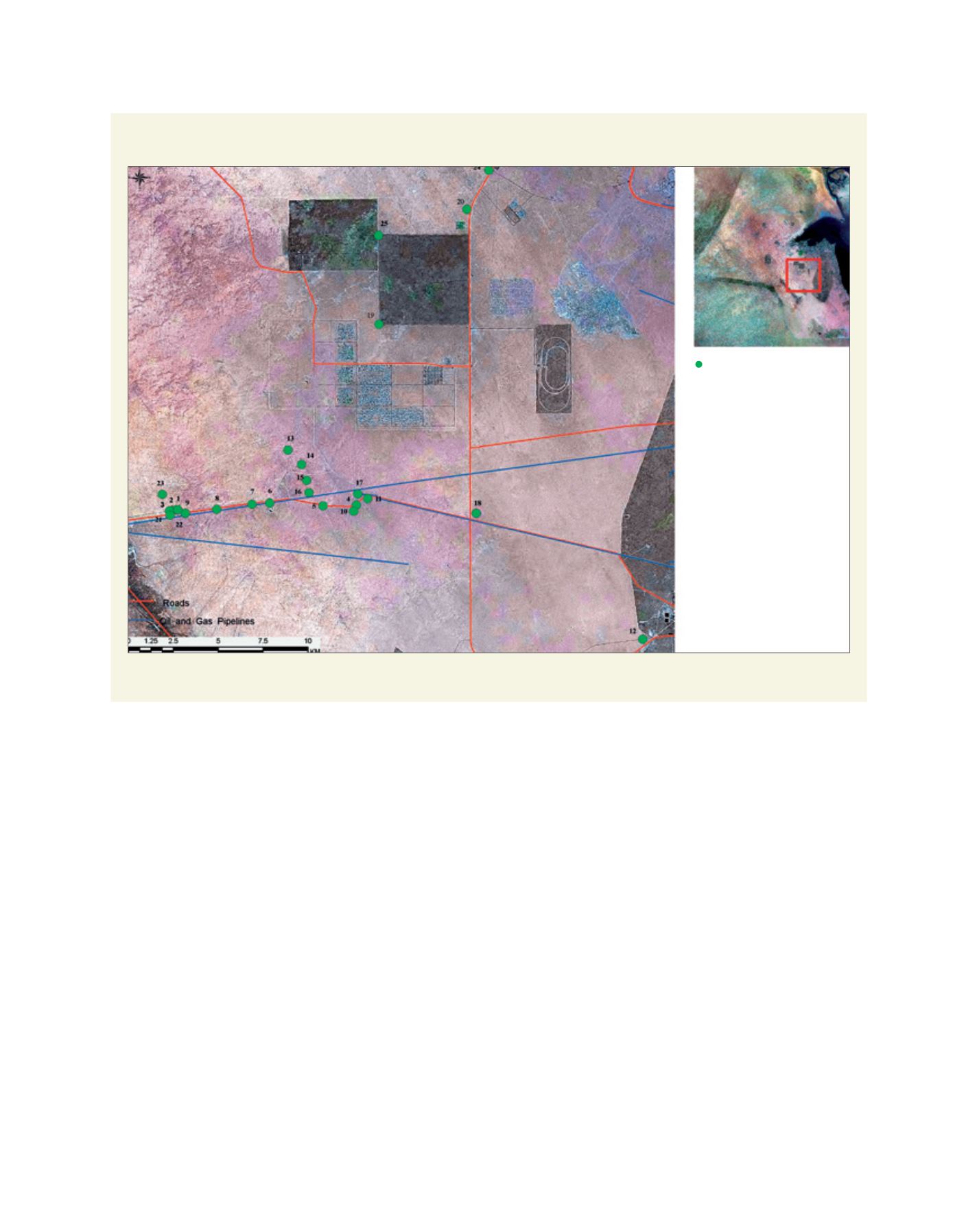
A satellite image showing facilities influenced by shifting sands (1-25) in the Kabd area
Source: National Committee for Combating Desertification in Kuwait (Kuwait National Focal Point, KEPA, 2015)
Classes of drought are:
• very severe: total annual rainfall less than 25 mm (seasons
1963/1964 and 1993/1994)
• severe: 25-50 mm total annual rainfall (seasons
1972/1973, 1976/1977 and 2007/2008)
• moderate: 50-75 mm total annual rainfall (seasons
1966/1967, 1991/1992 and, 2008/2009)
• slight: 75-100 mm total annual rainfall (very common
seasons 1964/1965, 1996/1997).
In Kuwait, current land use is environmentally classified into
three categories. Extremely destructive land use covers 10-12
per cent of Kuwait with damage extending 1-5 m from the
ground surface. Destructive ground use affects about 75 per
cent of the country with damage restricted to 50-75 cm of the
soil. Non-destructive land use, where damage is not observed
and natural recovery prevails, affects 12-15 per cent of Kuwait.
Land degradation processes prevail in the majority of the
terrestrial environment of Kuwait. Three classes of land degra-
dation are identified: almost non-degraded (12-15 per cent),
moderately degraded (75 per cent) and severely degraded
(10-12 per cent). Land degradation processes include soil
salinization and water logging, loss of topsoil (through both
wind and water erosion), soil crusting, sealing and compac-
tion, vegetation degradation and loss of biodiversity. In the
open desert areas (close to 51 per cent of Kuwait), where
livestock grazing is the major land use type, indicators of
soil, vegetation and hydrological degradation as well as loss
of biodiversity are prevailing. In the agricultural areas (about
2.7 per cent of Kuwait), depletion of soil productivity, water
logging and soil salinization are recorded.
The terrestrial environment of Kuwait, especially its central
part (about 60 per cent of the total area), is an open theatre for
extremely active aeolian processes. Wind erosion (soil drift-
ing) is very common in the areas of fragile sandy soils which
cover more than 50 per cent of the land. Soil drifting is a
major cause of land degradation and field measurements indi-
cate that the 2007/2008 dry season (less than 40 mm rainfall)
resulted in severe soil losses through wind erosion. In wide
stretches, winds removed 10-15 cm of topsoil (around 1,000
m
3
per hectare).
In the Kabd area (about 35 km south-west of Kuwait
City), hotspots (sites severely attacked by shifting sands)
were recently recorded. These include segments of roads,
water wells, industrial facilities, farms and other infrastruc-
tures. Drifting sands from deflated substrates encroach on
existing facilities.
Hot spots
(Severe sand encroachment)
L
iving
L
and