


 83 / 192

[
] 83
high-speed transportation as well as sustainable control meas-
ures in the country.
Active aeolian processes including abrasion, transportation
and accumulation are prevailing in wide areas of Kuwait’s
terrestrial ecosystem. These areas constitute 40-50 per cent
of the country. Assessment and monitoring programmes
for aeolian processes through ground stations and remote
sensing are basic requirements for designing action plans
for controlling encroaching sands. In addition, deep under-
standing of the mechanisms of sand transport and their
relation to current land use are essential for identifying the
magnitude and general trends of sand encroachment prob-
lems. Based on that, the best approach and techniques for
mitigating sand encroachment problems is selected.
The National Committee for Combating Desertification
in Kuwait
2
discussed the feasibility of reducing land degra-
dation from about 72 per cent in 2015 to 0-5 per cent in
2030. For this purpose, a 20-year land degradation neutral-
ity scheme is proposed. It consists of five programmes: land
degradation monitoring, mapping and assessment (ground
and remote sensing investigations); GIS-based knowledge
support system; restoration/rehabilitation (for soil, vege-
tation, wildlife and water supplies); sustainable land use;
and public awareness and human development. Managing
the hazards of shifting sands falls under the umbrella of
programme number four, sustainable land use.
In Kuwait the network of roads consists of six high-
ways: the Sabiyah, Salmi, Abdaly, Wafra-Mina Abdullah,
Wafra-Azour and Kabd highways. The magnitude of sand
encroachment along the highways is remarkably variable.
It is controlled by both local and regional conditions. In
general the most significant controlling factors are:
• road extension in relation to the main natural NW-SE
corridors of shifting sands (Huwamiliyah-Wafra and
Umm Qaser-Ras As Sabiyah)
• land use types in the upwind side of the roads (such
as open desert areas, protected areas, farms, buildings,
bundwall and green belts)
• availability of local sources of drift sands (dry wadis,
dissected hills, sabkhas, playas, sand sheets and
sand dunes)
• local geomorphologic and topographic conditions
• vegetation cover (density and types).
Based on recent field measurements, three degrees of sand
encroachment are identified along highways. Very severe
encroachment, where close to 50 per cent of the road is
vulnerable to sand encroachment, is represented by the
Al Salmi and Sabiyah roads. Severe encroachment means
that close to 30 per cent of the road is vulnerable, and
this category is represented by the Wafra-Mina Abdallah,
Wafra-Azour and Kabd roads. Moderate encroachment,
where close to 10 per cent of the road is vulnerable to
encroachment, is represented by the Abdaly Road.
An action plan has been proposed to manage the sand
encroachment problem along highways in Kuwait. It
consists of an integrated system of mobile sand control.
This system was successfully tested by the Kuwait Institute
for Scientific Research in the Kabd Experimental Station
in 2004. It comprises two impounding fences (2 m high,
chain-link type with slats) situated 100 m apart. Three rows
of drought-resistant trees will be planted in the middle
distance between the two fences. The total effectiveness of
this system is estimated to be around 28 years.
3
Characteristics and cost of the proposed mobile sand control system
Source: EPA Kuwait
Components
Sustainability
Cost per 1,000 m length *
Durability
Integrated mechanical- biological: double
impounding fences (about 100 m apart and
2 m high) with three rows of drought-resistant
trees in the middle
Very high (integration
between mechanical and
biological)
KD60,000:40,0000 (2,000 m of chain-
link fence)KD20,000 (cost of 600 trees
and irrigation for one year)
25-30 years
4
* Cost includes labour and materials. 1KD = US$3.5
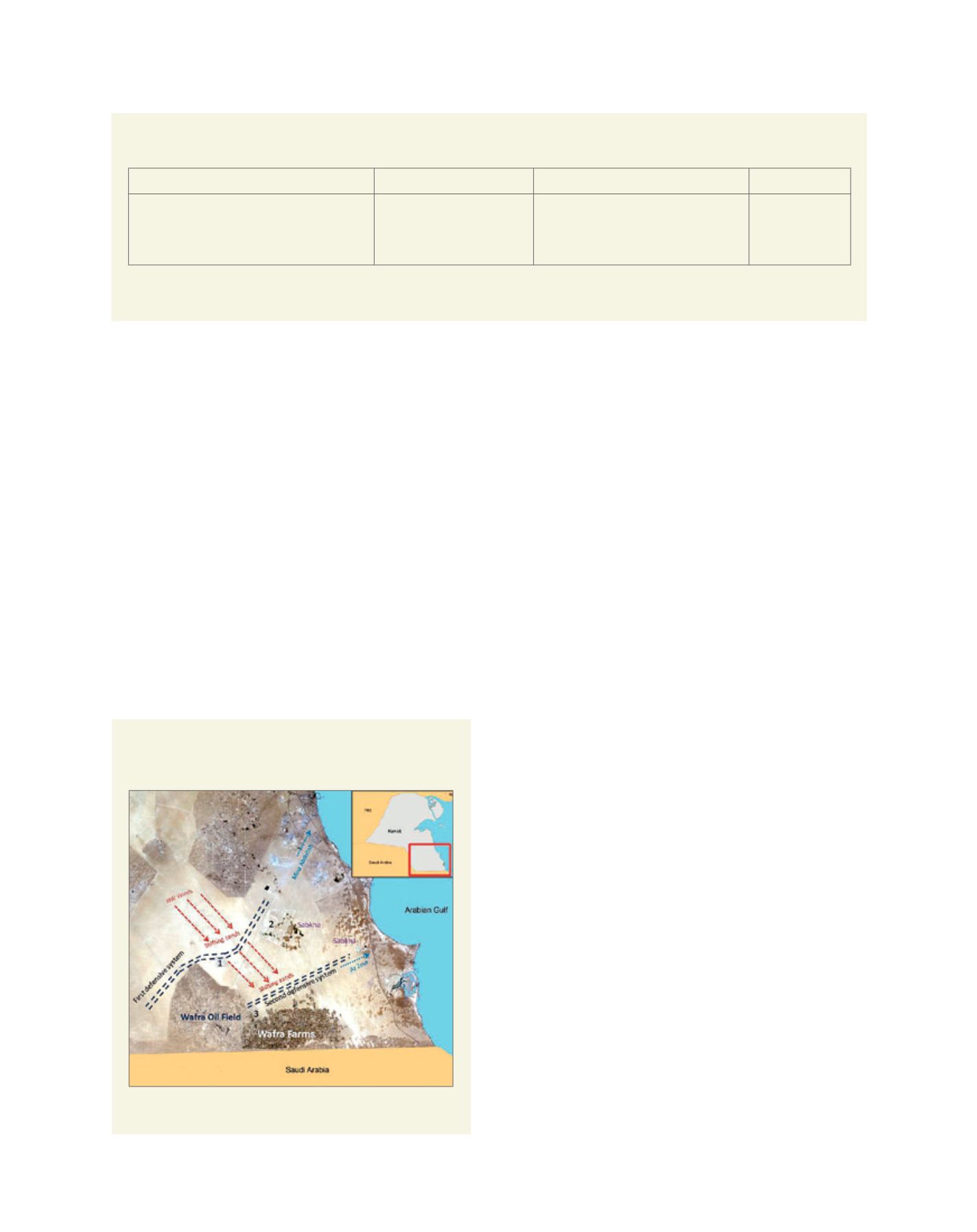
Proposed mobile sand control for the Wafra area: red
arrows indicate the direction of sand transport
Source: National Committee for Combating Desertification in
Kuwait (Kuwait National Focal Point, KEPA, 2015)
L
iving
L
and