


 266 / 280

[
] 266
the water stress state of land, and we have developed
a new vegetation index, the Water Stress Trend (WST).
Water is difficult both to warm up and to cool down,
and this means that the temperature variation of vege-
tation depends on the quantity of water stress. Based on
this water characteristic, the WST is estimated using
the extent of changes in temperature.
Recently, drought damage has become a serious
problem in Australia, and a WST analysis of 2005-2006
shows two distinct periods, with little water stress in
2005, but a lot in 2006. The WST is estimated from the
accumulation of differences in radiant temperature,
and is useful in detection of waterless areas.
Fire detection index (FDI)
SGLI does not have a 4 m channel, which plays a signif-
icant role to the detection of forest fire for MODIS and
upcoming VIIRS data processing. However, it does have
finer spatial resolution channels, such as 250 m for
1,600 nm and 500 m for 10.8 m. To detect the forest fire
from SGLI data, a thresholding technique will be avail-
able for 10.8 m, 2,200 nm and 1,600 nm channels. These
improvements in spatial resolution give SGLI an ability
to detect forest fire detection that is comparable with
that of MODIS and VIIRS.
Going forward
JAXA is developing a plan for GCOM, for the monitor-
ing of global environmental change, to be launched in
2013. One aspect of this mission will see SGLI onboard
the GCOM-C satellite, providing optical sensors from
Near-UV to MTIR. Characteristic specifications of SGLI
are as follows:
• Ultraviolet (380 nm)
• Three-direction polarization observation (red and
NIR)
• 250 m resolution (from near-UV to SWIR)
• 500 m resolution (MTIR).
From these new and unique characteristics, SGLI Land
products generate high-quality land surface reflectance
data which correct atmospheric effects. Therefore,
GCOM-C/SGLI data provides useful information for
many fields of human benefit.
On 16 February 2005, the Kyoto Protocol entered into
force, and the Third Earth Observation Summit has agreed
the Ten-Year Implementation Plan for GEOSS. The social
benefits of GEOSS mainly focus on nine areas: disasters,
health, energy, climate, water, weather, ecosystem, agri-
culture and biodiversity. GCOM seeks to establish a
long-term observation system for monitoring global envi-
ronment changes, improving knowledge of the climate
system and developing climate forecast models. GCOM-
C/SGLI is a useful satellite that enables an understanding
of the absorption levels of carbon dioxide in the land
ecosystem, and the monitoring of forest areas. Therefore,
SGLI is in a position to contribute effectively to the
Intergovernmental Panel on Climate Change, the Kyoto
Protocol, and GEOSS.
life, but waterless areas are spreading due to the impact of global
warming. By monitoring plant growth, it is possible to understand
Biomass change detection
using multi-angle observation data
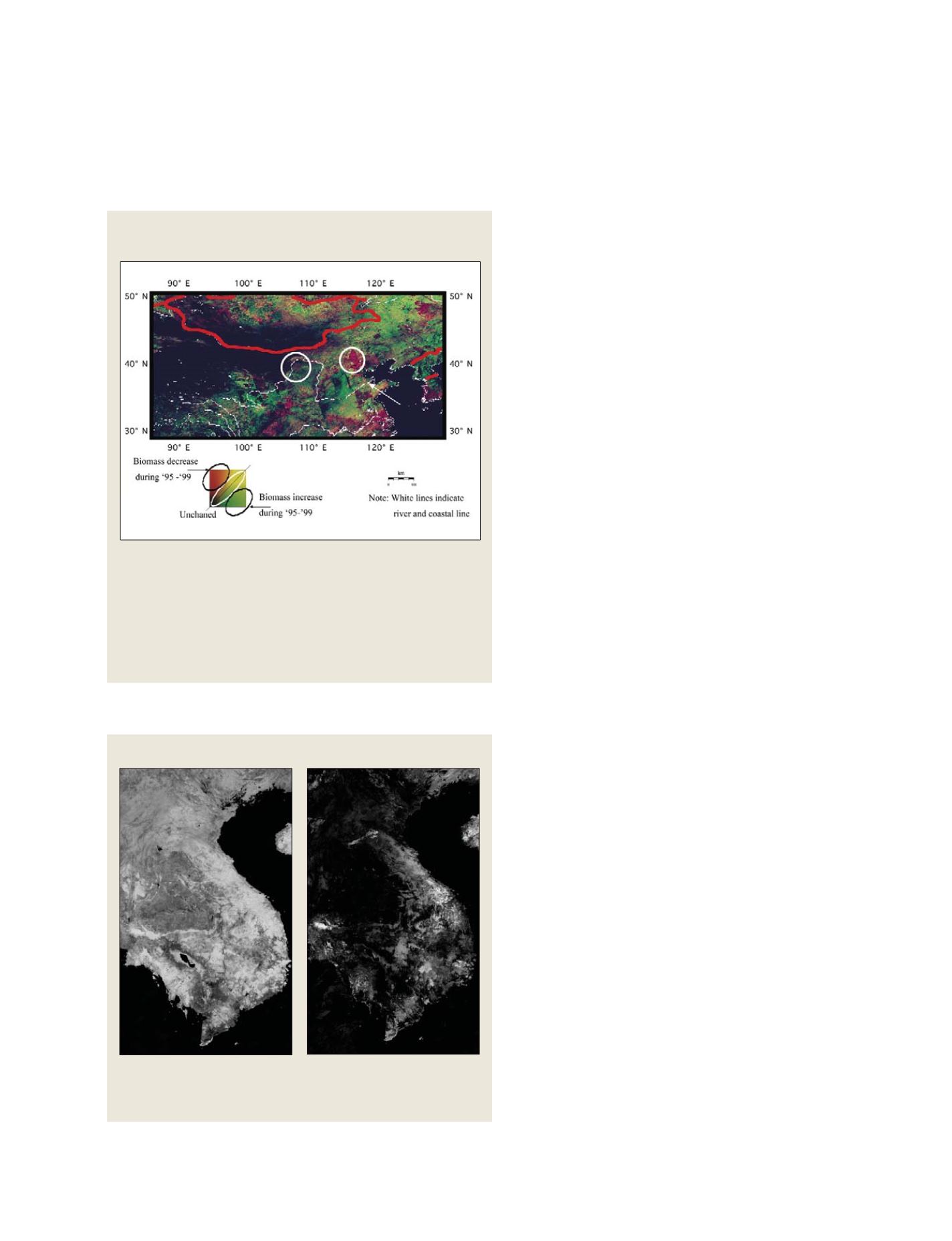
This image shows the change in vegetation biomass obtained from multi-
angle observation of red and NIR during 1995 to 1999 in China. The
regions enclosed by a white circle show large differences between 1995
and 1999. In these regions, vegetation cover changes significantly.
The observation used data NOAA/AVHRR data obtained from different
paths. With the SGLI, different angles of observation are available with a
long track – this means that SGLI can observe different angles of
reflectance in almost the same atmospheric conditions
Shadow index
Images of ADEOS-II/GLI 250 m data around the Indochina Peninsula on 7-
22 April 2003, showing (a) the NDVI image and (b) the SI image in
greyscale. The SI is estimated using the normalization method
(a)
(b)
S
OCIETAL
B
ENEFIT
A
REAS
– B
IODIVERSITY
Source: NOAA/AVHRR data
Source: ADEOS-II/GLI 250 m data