


 264 / 280

[
] 264
response. The interoperability experiments mainly considered the
A1B scenario.
3. A catalogue, such as GI-cat
9,10
allows discovery of, and access
to, the available biodiversity and climatological datasets. GI-cat
provides a consistent interface for querying heterogeneous cata-
logues and accessing servers that implement international
geospatial standards. In addition, GI-cat implements a mediation
server, making it possible to federate non-standard servers by spec-
ifying ‘interoperability special arrangements’. GBIF web services
were registered at GI-cat, which required a formal mapping of the
GBIF data model to the ISO 19115 core metadata profile, and the
adaptation of GI-cat to the GBIF service protocols.
4. A model provider is a component which is able to run an
ecological niche model on the selected biodiversity and climato-
logical datasets. It supports selection of datasets, setting of
parameter values and specifying of algorithm to be used. For
example,
the
open
source
OpenModeller
(http://openmodeller.sourceforge.net)software which is available as
a stand-alone application (OpenModeller Desktop) and as a model-
ling kernel that is accessible through specific modules
implementing external interfaces.
5. A Web-based Graphical User Interface (GUI) for the model
provider acts as workflow controller; it allows the access to the
GEOSS Clearinghouse to identify other needed services, imple-
ments the business process of the typical biodiversity scenario to
be run and controlled by the user through the GUI. We have devel-
oped a client application running in a web browser environment
using
AJAX
web
framework
technologies
(www.w3schools.com/ajax). With this tool, the user is guided
through the process of discovering data (by submitting queries to
GI-cat), accessing selected data (through GBIF and Open
Geospatial Consortium Web Coverage Services and
NCAR data servers) and running ENM projections.
These components play the three typical roles of a
Service Oriented Architecture (SOA) where ‘Consumers’
discover ‘Providers’ through a ‘Registry’. In the example
framework, data and model providers are the ‘Service
Providers’, the GUI-controller pair acts as a ‘Consumer’,
and the catalogue plays the role of the ‘Registry’.
In this paper we have described how the distributed
components needed for global change research can be
linked together. In this scenario the GI-cat catalogue
service has fulfilled the discovery and linking functions
of the GEOSS clearinghouse and the portal as these
were not available at the time this work was done in
early 2007. The GIS portal and GBIF Data Portal were
accessed directly. In the near future, these data services
will be registered and discoverable directly through the
GEOSS clearinghouse as well. GI-cat has been regis-
tered as a GEOSS component implementing an
international standard (OGC CS-W) registered as a
GEOSS service, making it interoperable with other
GEOSS components.
Our experiment demonstrates the role played by
international standards in supporting interoperability
and the effectiveness of establishing interoperability
special arrangements where these standards are not
fully supported. This is particularly important in estab-
lishing crosswalks among different information
communities. The catalogue has proven valuable in
managing linkages and integration of highly distrib-
uted resources.
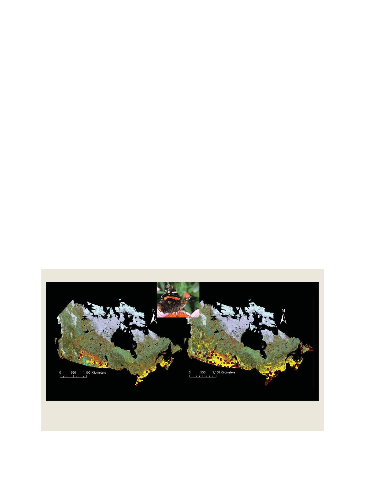
Tests using the Canadian butterfly species Vanessa atalanta
A) The distribution of
Vanessa atalanta
based on historical observations of climate, land use, and species location from 1900-1930. B) The distribution
of the species has expanded over the course of the 20th century, as shown here from models run on the same data from the 1960-1990 time period.
This use of the GEOSS framework demonstrates that species can be highly responsive to climate change and that forecasts for IPCC scenarios in the
future are viable and can usefully inform policy
Source: Kerr et al. 2007.
Vanessa atalanta
photo by Jeremy T. Kerr
A
B
S
OCIETAL
B
ENEFIT
A
REAS
– B
IODIVERSITY