


 217 / 288

[
] 218
Towards climate risk resilient cities:
spatially explicit land-use scenarios
Yoshiki Yamagata, Center for Global Environmental Research,
National Institute for Environmental Studies, Japan
A
s we face a future of human-induced increase of green-
house gases in the atmosphere, we need to prepare
for climate change impacts that will see tempera-
tures increasing 3-5° C since the industrial revolution. In
the process of urban planning, it is necessary to consider not
only climate change mitigation but also adaptation measures.
The Tokyo Metropolitan Area, which is still by far the largest
megacity in the world, is extremely vulnerable against climate
risks (especially flooding) because a large part of important
infrastructure is concentrated near the bay area. Climate
research projects increasing flooding risks in Tokyo due to
climate change as well as tsunamis from large earthquakes in
the future. We need to consider appropriate land uses that are
more resilient to climate risks.
Recently, in connection with the planning of low-carbon cities,
many urban planners have become aware of the ‘compact city’
concept. Because sprawled cities with low residential density
U
rban
I
ssues
depend inevitably on heavy car use, it is suggested
that a reduction in CO
2
emissions could be achieved
by changing urban form to a more compact style,
to increase the use of public transport. We should
also point out that compact cities are not necessarily
more vulnerable to climate and disaster risks.
We need to carefully analyse the implications of
different land-use scenarios. For instance, it is impor-
tant to consider the co-benefits of climate change
mitigation and adaptation measures. In order to come
up with an appropriate urban design in terms of
climate risk management, we need a tool that allows
us to conduct city-level scenario assessments. For
that purpose, we have created a new, spatially explicit
urban land-use model.
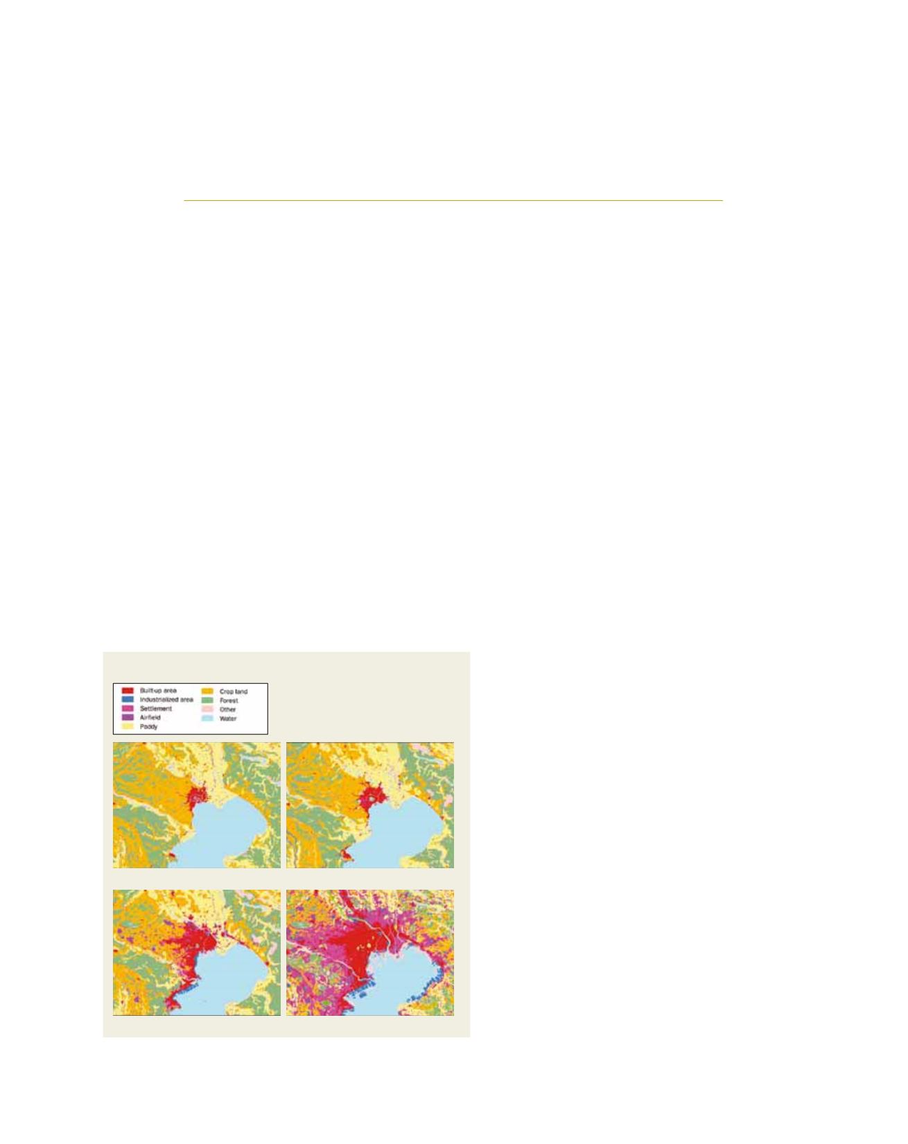
Urban development in Tokyo
Before looking into the future, let us look back on the
past 100 years of urban development in the Tokyo
Metropolitan Area. The images on this page show the
historical growth of the urban built-up area, estimated
from
The National Atlas of Japan
.
1
The maps were
digitized for the years 1888, 1914, 1946 and 1975,
then geographically registered, and urban areas were
delineated using a geographic information system
technology for conducting quantitative analyses. The
images illustrate the dynamic urban centre expan-
sion pattern, especially after the Second World War
(1950s) and the rapid suburbanization during the
fast gross domestic product growth period (1970s).
Urban expansion has continued and reached almost
a maximum during the bubble period (1990s). Since
2010, Japanese society has entered the phase of the
‘over-aged, population decreasing period’. One of the
most difficult urban issues in the near future will be
to consider how to achieve this shrinking phase in
a sustainable manner. It is financially impossible to
maintain all urban infrastructures equally, so we need
to make wise urban land-use scenarios.
Land-use scenarios and the heat island effect
The Center for Global Environmental Research,
National Institute for Environmental Studies urban
economics model calculates the interaction between
land, transport and energy use in cities. It describes
Source: The National Atlas of Japan, GSI
(a) 1888
(b) 1914
(c) 1946
(d) 1975
Spatial explosion of the Tokyo Metropolitan Area, 1888-1975