


 60 / 288

[
] 61
A
griculture
and scientists. The specific design allows interdisciplinary working
groups to stimulate cooperation and foster knowledge exchange.
Currently, the MOSAICC toolbox is under validation in Morocco,
after which it will be implemented in other countries. The model
development is funded by the European Union programme,
Improved Global Governance for Hunger Reduction.
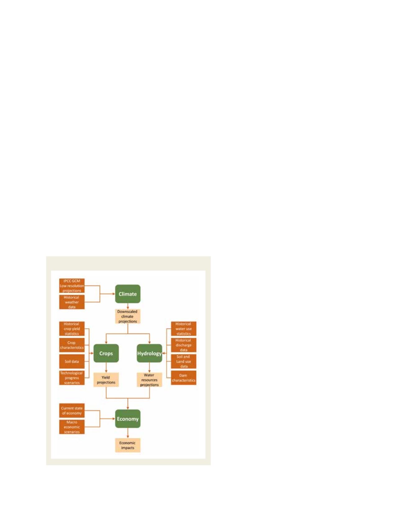
The system
The assemblage of the MOSAICC toolbox is based on a generic
methodology defined to assess the impact of climate change on agri-
culture, including statistical downscaling of climate data, crop yield
projections, water resources estimations and economic modelling.
Low-resolution (typically 250 km) climate data serve as primary
input for the whole model structure. These datasets feed the hydro-
logical and crop models, which need information on elevation, land
cover and soil. The outputs of these models subsequently serve as
input for the economic impact assessment.
Statistical downscaling portal for climate data
The climate scenario predictions are produced using observed
weather time series combined with global climate models (GCM).
The coarse resolution of the GCM needs to be downscaled to make
it applicable for the regional or country scale. A statistical downscal-
ing tool based on the Data Access and Downscaling tool is used.
1
This tool allows for downscaling large-scale predictors of data on
precipitation and minimum and maximum temperature to a set of
weather stations, provided enough observations are available.
Crop growth simulation
Two different models were selected to estimate the
crop yield. The first model is called WABAL, and was
designed to simulate the soil water balance at crop level.
Basically, it is a vertical soil profile, with no explicit
spatial extent. It is usually used at the level of agromete-
orological stations, pixels or cultivated areas. The model
requires a minimum number of inputs on precipitation,
evapotranspiration, soil water holding capacity and
crop parameters. Variables like the water requirement
satisfaction index, water surplus or deficit and actual
evapotranspiration are the outputs of WABAL. The
second model, also developed by FAO, is AQUACROP.
2
This model simulates the crop response to water in a
more sophisticated way. AQUACROP requires crop
parameters (data on crop physiology, cultivars, manage-
ment) that are much more sophisticated and more
difficult to acquire than the ones needed for WABAL.
A distinction is made between crop transpiration and
soil evaporation; furthermore the root development
and canopy cover can be simulated. Crop water stress,
biomass production and yield estimates are part of the
outputs. In addition, CO
2
concentration in the atmos-
phere can be taken into account. The selection between
WABAL and AQUACROP depends on the availability
and detail of climate information at country level.
Hydrological modelling
The Spatial Tools for River basins and Environment
and Analysis of Management options (STREAM)
3
is a
grid-based spatially-explicit distributed water balance
model that describes the hydrological cycle as a series
of storage compartments and flows. It was originally
designed for river basin studies with an emphasis on
water management aspects. The original version has
been successfully applied at spatial scales ranging from
small sub-basins
4
through medium to large basins
such as Krishna,
5
Zambezi
6
and Meuse,
7
up to the
(sub-) continental and global scale. STREAM calcu-
lates the water balance per time-step (user-defined,
typically 10-30 days) for a spatially distributed
gridded landscape. The model requires information
on precipitation, temperature, land cover, soil type,
depth and elevation. From temperature data the actual
and potential evapotranspiration are calculated using
the Thornthwaite equations.
8
MOSAICC uses the open
source version of STREAM; this version presents the
advantages of handling direct data on evaporation
and the ability to integrate dams using an automatic
calibration procedure. Furthermore, a new procedure
for flow accumulation has been implemented in this
version of STREAM.
Economic modelling
The economic modelling comprises a dynamic CGE
model that simulates the evolution of the economy
based on variations in crop yield projection.
9
The
model allows the user to define multiple activities
producing one commodity. To allow a spatial varia-
Source: FAO
A methodological flow-chart of MOSAICC