


 107 / 218

[
] 107
flight planning, greater safety for aircraft, passengers and crew,
and industry cost savings.
Funded by the aviation industry, the benefits of these systems
stretch far beyond this in terms of meteorological forecasting
and the climate. It is making an increasingly important contri-
bution to the observational database of the WMO’s World
Weather Watch (WWW), and the data they supply is expected
to supersede manual air reporting.
In recent years the numerical weather prediction community’s
requirement for capturing substantial amounts of automatic
meteorological data from aircraft has continued to grow, neces-
sitating further investigation into ways of capturing this data.
As a result, several national AMDAR programmes have been set
up, some of which are operational and some still in the plan-
ning stage.
Far-reaching benefits
While airlines clearly stand to benefit economically from
increasingly accurate weather forecasts, they also make a signif-
icant contribution to them. In addition, the benefits stretch far
beyond the world of commerce and air travel. Better, more
accurate meteorological information can enable more accurate
predictions of weather phenomena, such as the course and
intensity of hurricanes, the type of winter precipitation
expected and the severity of thunderstorms. Thus, it enables
better, more timely and accurate warnings of dangerous
weather events, and helps to save lives. In the event of a disas-
ter, the same services contribute vital information for the
planning and execution of rescue and aid operations.
The relations between aircraft and their natural environment,
the air, will remain challenging. Aircraft will continue to fly
through the air. They will increasingly provide real-time feed-
back to the ground about the quality of the layers of air they are
crossing. Doing so provides increasingly more accurate weather
prediction possibilities. This enables more safe and more effi-
cient flights and provides the world with a better weather
predicting capability in general.
lite pictures have been featured in television weather reports for
some years now) the role of aircraft in providing weather infor-
mation is perhaps less familiar.
For an accurate weather forecast, no matter what its purpose,
information about the air movement and temperature, and
increasingly humidity, at various altitudes is critical. Without
such information, no accurate weather forecast can be provided.
The only reliable information about these events is collected and
transmitted by aircraft crossing vertically and horizontally
through these layers of air. In this way, more accurate informa-
tion is delivered enabling forecasters to more precisely do their
work.
The aviation industry funds and provides a significant amount
of crucial meteorological data. Two programmes in particular
provide millions of observations for use in the global model,
which is used not only for near-time forecasting but also to help
establish a baseline for climate models, due to its understanding
of how the atmosphere works. In addition, the climate commu-
nity uses surface observations from the aviation community to
establish a baseline.
MDCRS and AMDAR
Over recent years it has become evident that significant valu-
able meteorological data can be obtained from large areas of the
world by collecting data from aircraft. The Meteorological Data
Collection and Reporting System (MDCRS) and the Aircraft
Meteorological Data Reporting (AMDAR) system are designed
to support improved weather forecasting, particularly for upper-
air wind and severe weather. Both systems work to feed
information to their respective homeland WAFC, in the US for
MDCRS and Europe for AMDAR.
The systems collect and organize up to 28,000 real-time, auto-
mated position and weather reports per day from the aircraft of
participating airlines. The data are then forwarded to the relevant
WAFC where it is used as input for the global forecast model.
By helping forecasters to more accurately predict winds aloft
and areas of severe weather, the system contributes to better
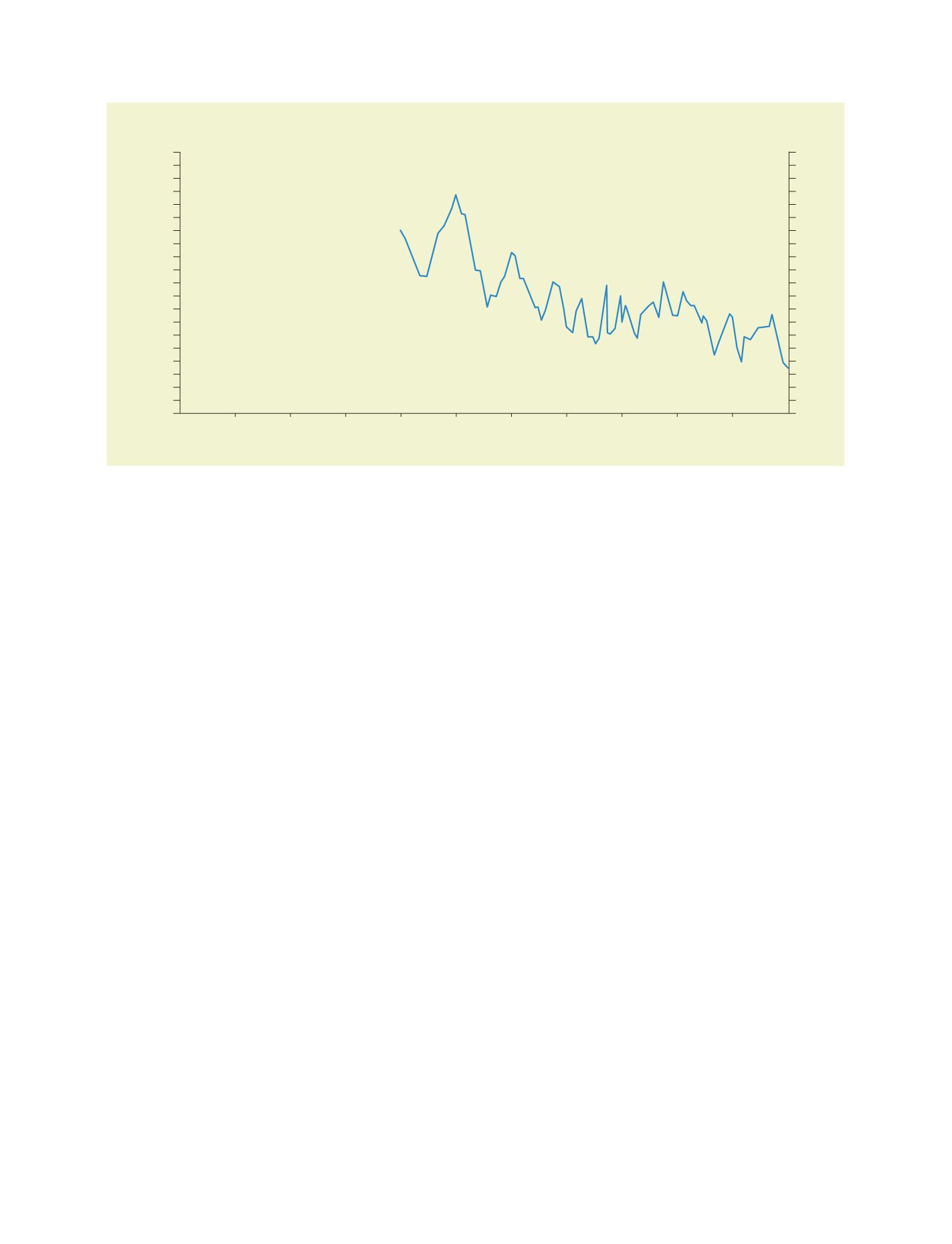
1996
1997
1998
1999
2000
2001
2002
2003
2004
2005
2006
3.5
4.0
4.5
5.0
5.5
3.5
4.0
4.5
5.0
5.5
FC-Anol Time-Av RMS Vector Error
Wind (m/s) at 250.0 hPa: Analysis Northern Hemisphere (CBS area 90N-20N): T+24
WAFC London wind forecasts
Source:
http://www.metoffice.gov.uk/icao/wind/nhemi.html