


 162 / 192

of trees is banned through religious sentiments. This
approach was demonstrated in the restoration of Badrivan
in Badrinath — a famous Hindu shrine at high altitude
in Uttarakhand,
7
and Raksha Van (a defence forest) estab-
lished by army people in 10 hectares of land at Bantoli
(Badrinath). Also, at Kolidhaik village (Champawat district,
Uttarakhand) 5.6 hectares of degraded land was brought
under plantation of 6,200 saplings of 20 MPTs which have
attained over 3-4 metres in height. This approach was
included by the International Union for Conservation of
Nature in its guidelines for planning and managing moun-
tain protected areas.
8
It can be inferred from the above mentioned case studies
that owing to the great biophysical diversity of the IHR a
range of approaches would be required to address waste-
land rehabilitation/restoration and stop further degradation
of land. Some of the major recommendations drawn from
our studies are to:
• strengthen village institutions as they comprise
crucial traditional knowledge on natural resource
management; the best practices must be scaled up
• promote participatory consultation with communities
to share knowledge, beliefs and resources for
rehabilitation of degraded land
• emphasize ecological, agroecological, and
socioeconomic considerations
• develop strong linkages among technical institutions,
village institutions, practitioners and policy planners
• strengthen formal and technical information networks
on land rehabilitation engineering, erosion control
measures and productivity enhancing techniques
• include religions and cultural/economic/livelihood
concerns in rehabilitation activities and incentives for
participation
• facilitate community skill development and training on
key sectors of ecological rehabilitation of wastelands.
tion (0.95-2.09 t C/ha
-1
/year
-1
), and fodder harvest (14.4 t/
ha
-1
) was recorded. Vegetables grown in this demonstration
site were consumed and sold by the stakeholder fami-
lies.
5
Similarly, in Dharaunj (14 ha) and Gumod (6.5 ha)
villages of Champawat district (Uttarakhand) cash crops
of medicinal and aromatic plants (MAPs) were planted and
capacity-building of farmers on cultivation, harvesting, value
addition, packaging and marketing of MAPs was undertaken.
Income generated from
Ocimum basillium
(Rs98,500 per
hectare) encouraged 120 farmers to adopt MAPs for income
generation and a benefit-sharing mechanism was devised by
forming a MAPs growers group.
In the shifting cultivation (jhum) affected area in the
north-eastern IHR, extreme soil erosion and loss of soil
fertility has accelerated the pace of land degradation and
reduced crop yield. In such areas contour hedgerow inter-
cropping was practiced, which involved the planting of
local leguminous nitrogen fixing shrubs at 1.5 m to 2 m
distances (the alleys) along contours. Crops were grown in
the alleys by applying a mulch of these hedgerow species
to improve soil fertility (nitrogen from 0.165 per cent to
0.173 per cent) and yield of vegetables (20 per cent to 100
per cent). Soil erosion was reduced to 50 per cent after
three years.
6
Eco-restoration of degraded forest land:
Mobilizing people
for plantation of degraded forest lands in the high alti-
tudes is rather a tough task as this land is owned by the
Government and people often do not consider themselves
to be the real stakeholders. In such land, the creation of
sacred forests and integration of science with religion was
adopted as an innovative approach for inviting the partici-
pation of the people. After eco-physiological scrutiny,
plants acclimatized for high altitude were distributed as
‘Briksha Prasada’ by the local religious authority to pilgrims
and local people, and were planted as an act of devotion.
The plantation is dedicated to the local deity, and cutting
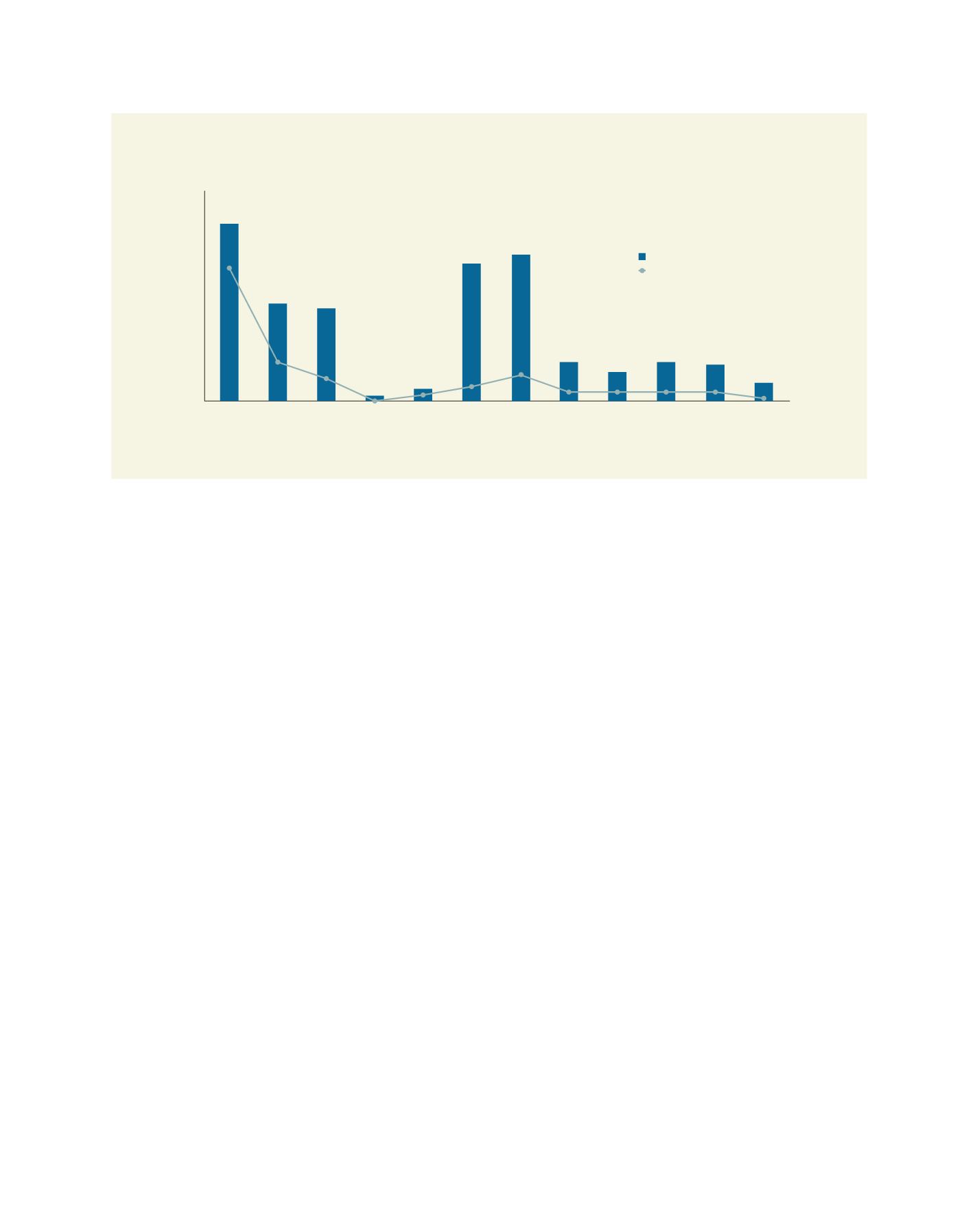
Total geographical area of different IHR states and their respective total wasteland area (for West Bengal only,
Darjeeling district is considered)
Source: Wasteland Atlas of India, 2011
120,000
Jammu
& Kashmir
Himachal
Pradesh
UttarakhandDarjeeling Sikkim Assam Arunachal
Pradesh
Meghalaya Nagaland Manipur Mizoram Tripura
100,000
80,000
60,000
40,000
20,000
0
Total wasteland 2008-09 (sq km)
Total geographical area (sq km)
[
] 162
L
iving
L
and