


 50 / 280

[
] 50
In December 2003 an earthquake with a magnitude of
6.5 hit the town on Bam in Iran killing 40,000 people.
In the month following the quake, COMET researchers
joined scientists from the Geological Survey of Iran to
find the source of the quake. Radar images revealed that
the earthquake occurred on a rare blind ‘strike-slip’ fault.
In strike-slip faults the blocks of crust move sideways
relative to one another, as the blocks are moving side-
ways, rather than up and down. In this case, only small
traces of the fault slip reached the surface, and signs of
movement in previous earthquakes had been buried by
layers of sediment. In addition to showing the location
of a fault, satellite images of earthquakes enable us to
visualize the structure of an entire region, which helps
us to understand the cause and impact of a quake. At
the moment, radar images of quakes can be used to
locate the source of an earthquake and to help predict
and therefore minimise the impact of future quakes.
However, as the number of radar satellites increases, the
repeat time between passes will be reduced, and the time
taken to determine the location of a quake will be
reduced from a few weeks to a few days. When this
happens, satellite images could become a valuable tool
for those planning the relief effort as the satellite images
could show the scale and extent of devastation across a
whole region.
Boreal forest fires
One of the regions where the impact of global warming
will be greatest is in the high latitude forests of the
northern hemisphere. In order to help us understand
the effect of environmental change on these boreal
forests, scientists based at the Climate and Land Surface
Systems Interaction Centre (CLASSIC), in association
with the Sukachev Institute of Forest and the Siberia
Earth System Science Cluster, have been studying the
relationship between environmental change and fire in
Siberian forests. Fire is a cause of major environmental
change in Siberia. For example 38,000 square kilometres
of boreal forest were lost to fire in 2003. Fire frequency
data from the MODIS satellite has been combined with
rainfall and population density data for Siberia. This
work to establish the factors that control of distribution
of fire in Siberia has shown that fire in the boreal forests
is influenced by regional rainfall anomalies, human
population density and large scale climate patterns, such
as the Arctic oscillation.
UK industry plays a major role in supporting the
priorities of UK scientists through the development of
technologies and instrumentations that can satisfy data
requirements. Working within ESA, BNSC leads the two
Global Monitoring for Environment and Security
(GMES) Service Elements (GSE) – Respond (humani-
tarian aid) and Terrafirma (geohazard risk management).
In addition, the UK is a member of the Disaster
Management Charter (DMC), where the UK DMCii is
helping to coordinate a constellation of international
satellites that contribute to the voluntary system called
upon in times of crisis. This is providing a very impor-
In order to improve the coordination of Earth observation activi-
ties in the UK, two centres have been created. The Centre for Earth
Observation Instrumentation (CEOI) is currently jointly funded by
BNSC Partner organizations NERC and the Department of
Innovation Universities and Skills (DIUS), and aims to bring together
people from academia and industry in order to provide the UK with
an internationally competitive Earth observation instrumentation
and technology research and development programme. The second
centre is the complimentary National Centre for Earth Observation
(NCEO), which is currently under development and due to become
operational in spring 2008. This centre will build on the consider-
able Earth observation expertise in the UK and will use data from
Earth observation satellites to monitor global and regional changes
in the environment, so that we might predict future environmental
conditions. In addition, the NCEO will provide training in Earth
observation and will be responsible for knowledge transfer activi-
ties, including increasing awareness of initiatives such as GEO within
the UK Earth observation Community.
The UK’s commitment to Earth observation, and the use of Earth
observation data to address many of the problems facing our society,
is best highlighted through example.
Polar observation
Researchers, from the UK’s Centre for Polar Observation and
Monitoring (CPOM) have been monitoring the scale of changes in
Antarctic glaciers using satellite data. Scientists are studying radar
images of four Antarctic glaciers, the Totten and Cook glaciers on
the eastern Antarctic ice sheet, the Pine Island Glacier and the
Thwaites glaciers on the western Antarctic ice sheet. They have
discovered that over the past five years these glaciers have been
moving between 20 per cent and 100 per cent faster than in previ-
ous decades and are adding more water to the oceans, contributing
to rising sea levels.
Earthquakes
Researchers from the UK’s Centre for Observation and Monitoring of
Earthquakes and Tectonics (COMET) have been using radar images
from ESA’s ENVISAT satellite to pinpoint the location of earthquakes.
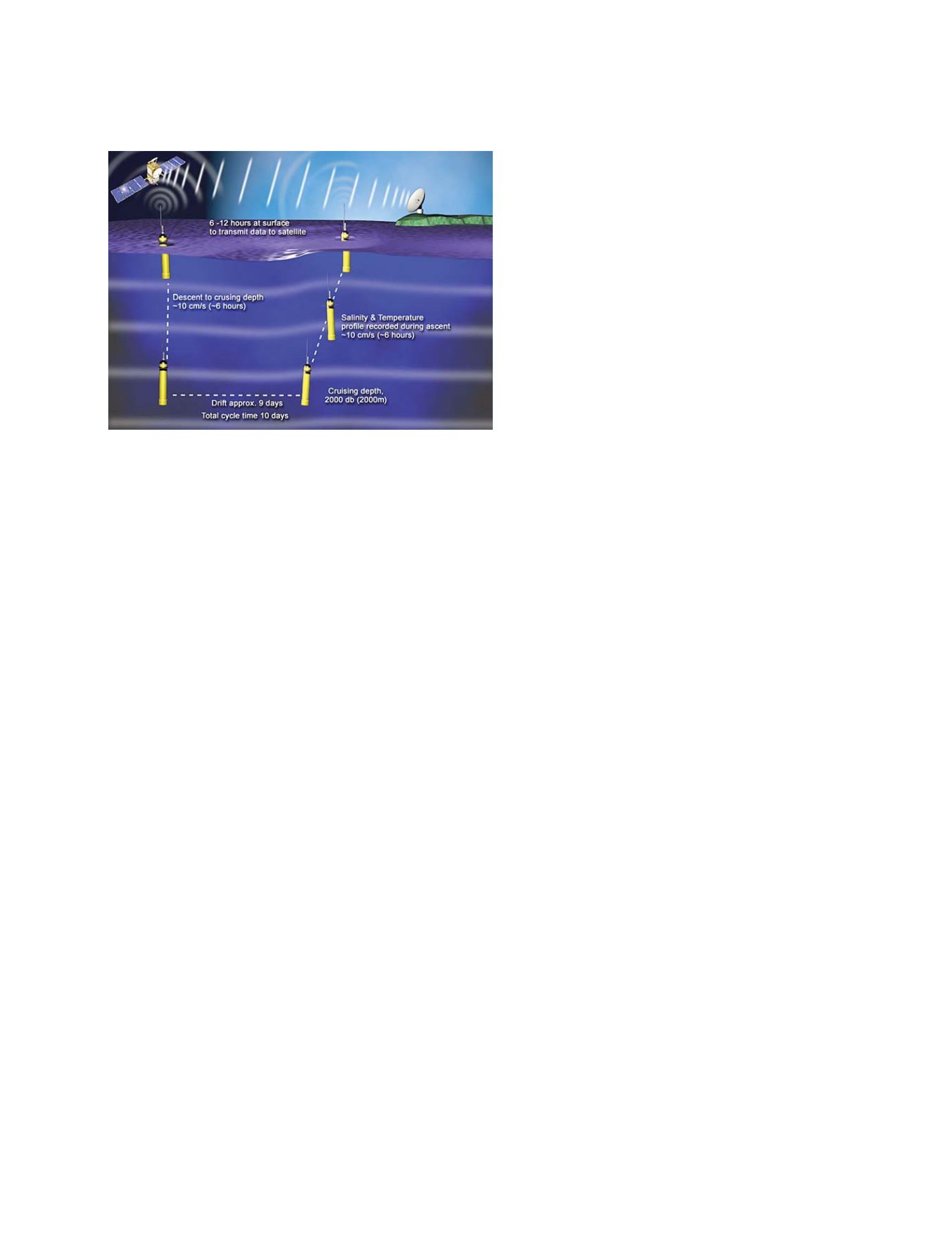
Source: NERC
Argo floats use a combination of in situ and satellite observation technologies
working together
N
ATIONAL
& R
EGIONAL
R
EPORTS