


 203 / 288

[
] 204
E
cosystems
using more than 50 million measurements of varia-
tions in gravitational attraction. For the first time, its
measurements also allow global currents to be extracted
directly from satellite altimetry data: ocean currents are
understood as a major engine of our global climate.
The ESA Soil Moisture and Ocean Salinity (SMOS)
mission followed in November 2009. SMOS provides
the first global measurements of two key variables in
the water cycle – soil moisture and ocean salinity. Thus,
scientists are able to trace the inter-annual variation of
water available in soils and produce accurate ocean
surface salinity maps around Earth.
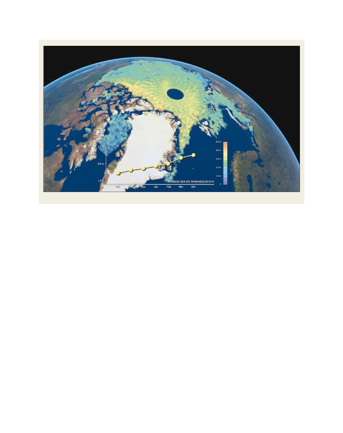
Only five months after the launch of SMOS, the third
Earth Explorer – ESA’s Ice mission Cryosat – was deliv-
ered into orbit inApril 2010. TheCryoSatmissionmeasures
ice sheet thickness and volume in the Arctic and Antarctic
for the first time ever. This allows a new understanding of
the complex relationship between ice and climate. In April
2012, scientists published the first Cryosat seasonal cycle
of arctic ice thickness (October 2010 to April 2011). A
few months later, satellites witnessed an alarming record:
the lowest Arctic sea ice extension since the beginning of
systematic measurements.
The next mission, ready for launch, is ESA’s magnetic
field mission Swarm, which will provide the best ever
survey of the Earth’s geomagnetic field and its varia-
tion in time while enabling new insights into the Earth’s
interior and climate. Further Explorers are under
development or selection. Each mission uses the most
political action upon climate-related data. Satellites deliver such data
in a reliable way.
The European Space Agency (ESA) is a pioneer in terms of Earth
observation satellites. It has been instrumental in making meteorol-
ogy one of the first sustainable and operational space applications
in Europe, having put efforts into the development of the Meteosat
missions since the 1970s. The long-lasting ERS-1 and ERS-2
missions, as well as Envisat, the world’s largest Earth observa-
tion satellite ever, have provided an immense amount of valuable
research data to more than 4,000 scientific projects worldwide and,
routinely, to service providers every day. The data collected by
sophisticated sensors over decades form a vast archive that is still
far from being completely exploited.
One of the most urgent topics is the understanding of the under-
lying mechanisms of climatic change, and the contribution of
humankind to it. In order to arrive to useful findings it is indispen-
sable to look at the state of and, more importantly, the changes in
the Earth’s climate which come about as the result of the interaction
between components such as the atmosphere, cryosphere, hydro-
sphere, land masses and not least the human sphere of influence.
ESA is developing a veritable fleet of Earth Explorer missions that
shed light on open questions regarding these Earth systems. Three
Earth Explorers are already in space.
Gravity field and steady-state Ocean Circulation Explorer
(GOCE), a mission to map the Earth’s gravity field with unprece-
dented accuracy, was launched in March 2009. GOCE has produced
the most accurate model of the geoid ever produced. In doing so,
the satellite carries the first gradiometer in space at one of the lowest
satellite orbits ever (about 255 km). GOCE’s geoid has been created
A scientific novelty – the first Arctic seasonal ice volume change data delivered by Cryosat
Source: ESA 2012