


 76 / 288

[
] 77
W
ater
days), taking advantage of the ECMWF products, is
operational for flood and low-flow forecast for the
main French rivers, and products are delivered to the
relevant users. Seasonal forecasting is currently under
evaluation: although the signal over Western Europe
is rather dim both in terms of temperature or precipi-
tation, it has been shown that predictability can be
found for water resources, mainly due to snowpacks
in the mountain areas, delayed aquifer response and,
in very few cases, soil moisture.
3
No doubt in the near
future, the set of timescales offered to users will also
encompass the seasonal ones.
The information is produced on an 8 km regular
grid covering the entire territory. This makes the
management of data and the elaboration of prod-
ucts easier. Products can therefore be elaborated for
a given region or a department. Administrative divi-
sions can be chosen, and of course river basins. In this
way, the drought in the Languedoc-Roussillon admin-
istrative region in March 2012 was clearly recorded
and a warning with references to past extreme events
was issued by the authorities regarding the need for
careful usage of water. Rainy conditions during spring
brought the Soil Wetness Index (SWI) back closer
to normal, permitting a looser watch on the condi-
tions which were manageable until summer when the
drought came.
The hydrometeorological and climatical informa-
tion is delivered to actors by various means. Dedicated
websites are the main way for delivering all relevant
materials to users, both at the national level (Ministry)
and for regional and local entities. Notifications and
bulletins are produced on a monthly basis, or in case
of a particular need. Météo-France experts also take
part in hydrological coordination commissions, where
all stakeholders share their views on water use. Results
are disseminated through a website.
4
The agencies in
charge of water management are also directly connected
to Météo-France climatologists hotline, enabling effi-
cient support especially in case of a tricky situation.
They also collect products and data for fulfilling their
everyday duties as well as for running research and
development projects.
Climate change impact on water resources
France is concerned by the impacts of climate change
on water resources. Until recent years, attention has
been mainly paid to precipitations or river flows,
especially for large basin rivers.
5
In 2007, it was
decided to conduct a project tackling the effects of
climate change on water resource and droughts. The
ClimSec project had a twofold objective: to charac-
terize past evolution and to provide scenarios for the
future. It was decided to use a physical model, able to
describe the atmosphere – vegetation – soil interac-
tions rather than older parametric approaches based
on potential evapotranspiration. Quite logically, the
SIM was selected, because of its consistency with the
other productions.
gather a greater number of observations, rerun at the end of each
month so that its analysis benefits from the integration of the non-
automatic observations made by voluntary observers, and rerun
at the end of each year to retain the best homogenous archive for
climatological applications.
Project after project, day after day, the numerical suite has
been improved to represent increasingly sophisticated details
and physical processes. Research is of course still ongoing to
improve the models! A transfer of the system to the operational
teams was done in the early 2000s. Since then, it is operated
routinely, run every day in order to describe the past weather
conditions that prevailed over the country. Such an opera-
tional product is quite useful for monitoring water resources
(soil moisture, river flows) and for assessing the magnitude of
extreme events, namely droughts. The SIM system is of course
used for climate monitoring and extreme events evaluation
(notably for natural disaster assessment).
Thanks to the 1958-to-present reanalysis, a climatology of the
SIM variables is available for use. Current situations can therefore
be compared to past events or climatological references. This helps
users to evaluate the level of magnitude of a given event or situation
compared to historical references.
Daily, weekly, monthly and yearly products are used for climate
monitoring and support of the French authorities and agen-
cies in charge of water management, from national (SCHAPI,
Service Central d’Hydrométéorologie et d’Appui à la Prévision des
Inondations) to local levels. The information is tailored to cover
the various administrative districts mapping France, as well as the
hydrological watersheds and basins. The suite is used not only
for monitoring and analysis, but also for prediction. Two types
of predictions are run. Mid-range ensemble forecasting (up to 10
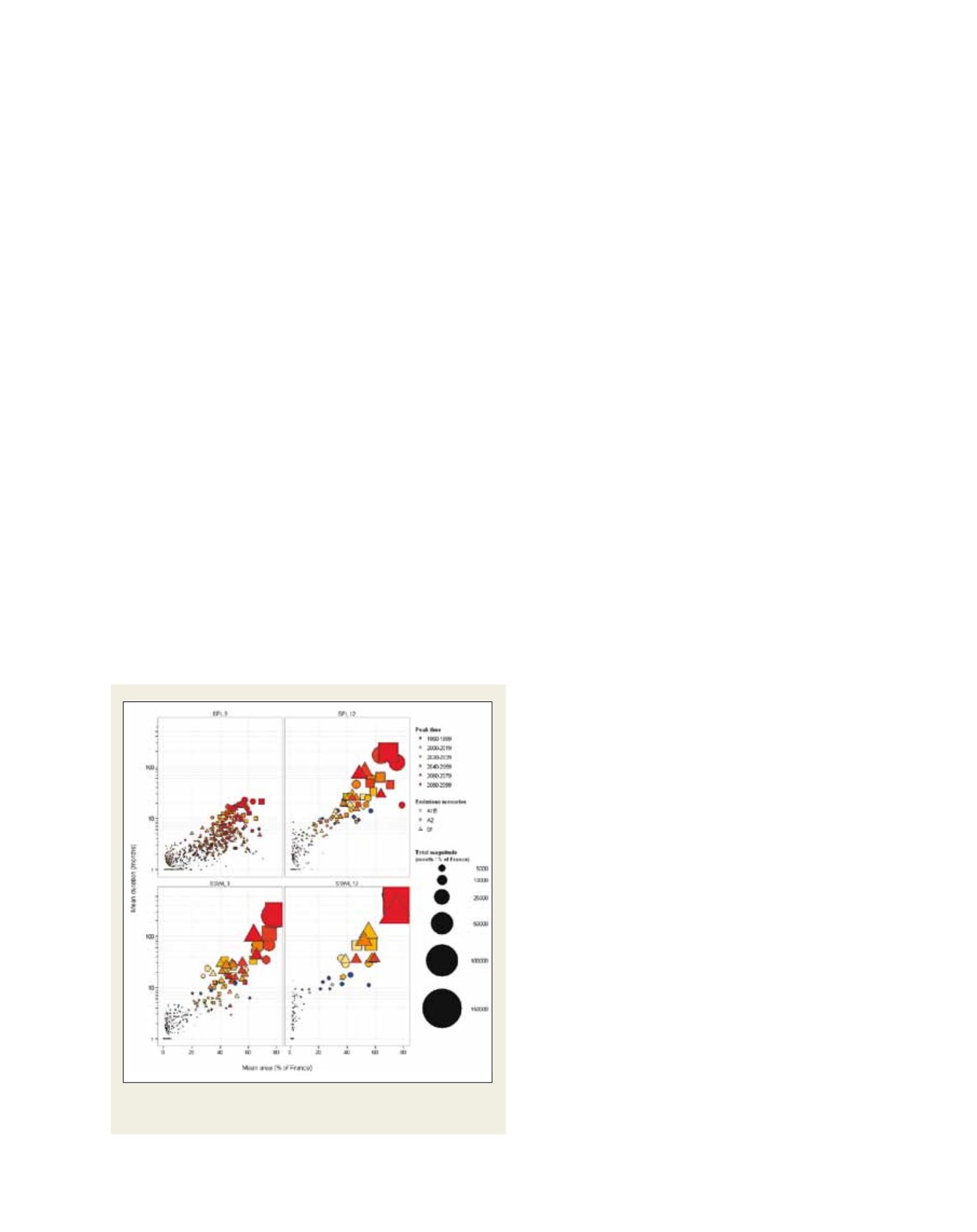
Climate change scenarios for two precipitation and soil wetness indices
(with logarithmic scale)