


 130 / 192

[
] 130
flexible monitoring system that analyses multitemporal data over
the year (see case study).
Conclusions
The importance of global and sustained EO for monitoring
dryland conditions has been stressed by all UNCCD stakehold-
ers. The availability of long-term series of historical satellite
observations allows us to measure trends of global indicators
such as land cover and land productivity that are essential to
assess land degradation and plan rehabilitation of degraded lands.
The use of satellite information also provides opportunities for
the development and verification of sustainable land practices
in marginal rain-fed lands. As stated by an IFAD officer, “Poor
rural people are on the front line of climate change impacts. The
ecosystems on which they rely are increasingly degraded, their
access to suitable agricultural land is declining, and their forest
resources are increasingly restricted.” EOs provide accurate and
consistent information that can support strategic planning and
deliver quality solutions to these local rural communities.
ESA will continue to develop innovative EO solutions that
support the collaborative efforts to achieve land degradation
neutrality. This starts by empowering developing countries
with knowledge and skills on how to use EOs for a sustainable
management of their soil, water and biodiversity. Europe recently
launched the first Sentinel satellites of its flagship Copernicus
initiative, whichwill provide free and open access to satellite infor-
mation to protect the environment, mitigate the effects of climate
change and ensure a sustainable use of natural resources. ESAwill
pursue the collaboration with the Rio Conventions and the IFIs
to mainstream the use of EOs within sustainable land practices.
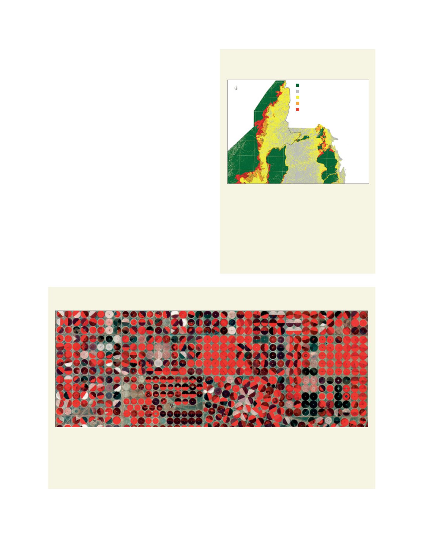
Case study: Irrigated agriculture observed by Sentinel 2
Despite the benefits that irrigated crops bring to local communities,
some environmental issues exist such as depletion of water
resources, soil erosion, run-off of chemicals, salinization of the soil
and drainage of nutrients.
The Sentinel-2 mission, whose first satellite was launched in June 2015, will
deliver high-resolution optical images of all land surfaces. The five-day revisiting
together its 10 m resolution and its high spectral content make Sentinel 2 an
essential tool for monitoring agricultural practices such as irrigated crops.
Source: Copernicus Sentinel data (2015)
A Sentinel 2 false-colour image showing agricultural structures near Tubarjal, Saudi Arabia, characterized by a central-pivot irrigation system
L
iving
L
and
Case study: Dry forest mapping in the
Miombo woodlands
The Miombo woodlands with their varying phenology related to
dry and rainy seasons have been identified as a priority ecozone
because of their unique endemism.
The image shows the status of the Miombo forests between
Zambia and Malawi, and the changes between three epochs (1990,
2000 and 2010).
The Miombo forests are widely harvested to provide fuelwood
and to be converted in agricultural lands. The loss of dry forests are
shown in orange (1990 to 2000) and red (2000 to 2010).
Source: ESA GSE Forest Monitoring project/GAF AG
Status of the Miombo forests between Zambia and Malawi
NIF - Non-Intact Forest 1990-2010
IF 1990 to NIF 2000/2010
IF 2000 to NIF 2010
NF - Non-Forest 1990-2010
IF - Intact Forest 1990-2010
Zambia
Malawi