


 132 / 192

[
] 132
covered latitudes between 86°N and 86°S globally. The laser’s
return pulse was detected by a telescope on-board ICESat.
GLAS recorded the changes in laser energy intensity as a
waveform, and the waveform contained information on the
vertical structure of forests. At flat areas, the height differ-
ence between signal start and signal end corresponded to the
maximum canopy height within the footprint. If a waveform
was bulky at high elevation, the observation was considered
to have been made at a high-biomass forest because it meant
a large reflectance from the canopy level. In this way, many
studies have been conducted to analyse the GLAS waveform
to estimate canopy height and AGB.
We developed a methodology to estimate canopy height and
AGB using GLAS data, and evaluated its performance. A technol-
ogy to accurately measure canopy height or AGB using satellite
data will make it possible to acquire enormous amounts of data
on forest resources without labour-intensive in-situ measure-
ments. The study area was Borneo. The tropical forests in Borneo
have a considerable canopy height and are rich in biomass even
on a global scale, and also rich in biodiversity with many rare
animals and plants. However, the area of forests in Borneo has
been rapidly decreasing in recent years because of forest fires,
oil palm plantation development and so on. Therefore, Borneo
attracts attention from REDD+ implementations.
We collected field-measurement data of canopy height and
AGB in 37 plots which coincided with the GLAS footprints.
We used the data as reference data to examine the relation-
ships between some parameters of GLAS waveform shape
and canopy height or AGB. These relationships could be
used to estimate canopy height and AGB from GLAS data.
The estimation accuracies (root-mean-square errors) were
4 m for canopy height, and 38.7 t/ha for AGB. Among the
field-measurement sites, there was a rich forest where tree
height was 30 m and AGB was 300 t/ha. However, accuracy
remained high even in such a forest.
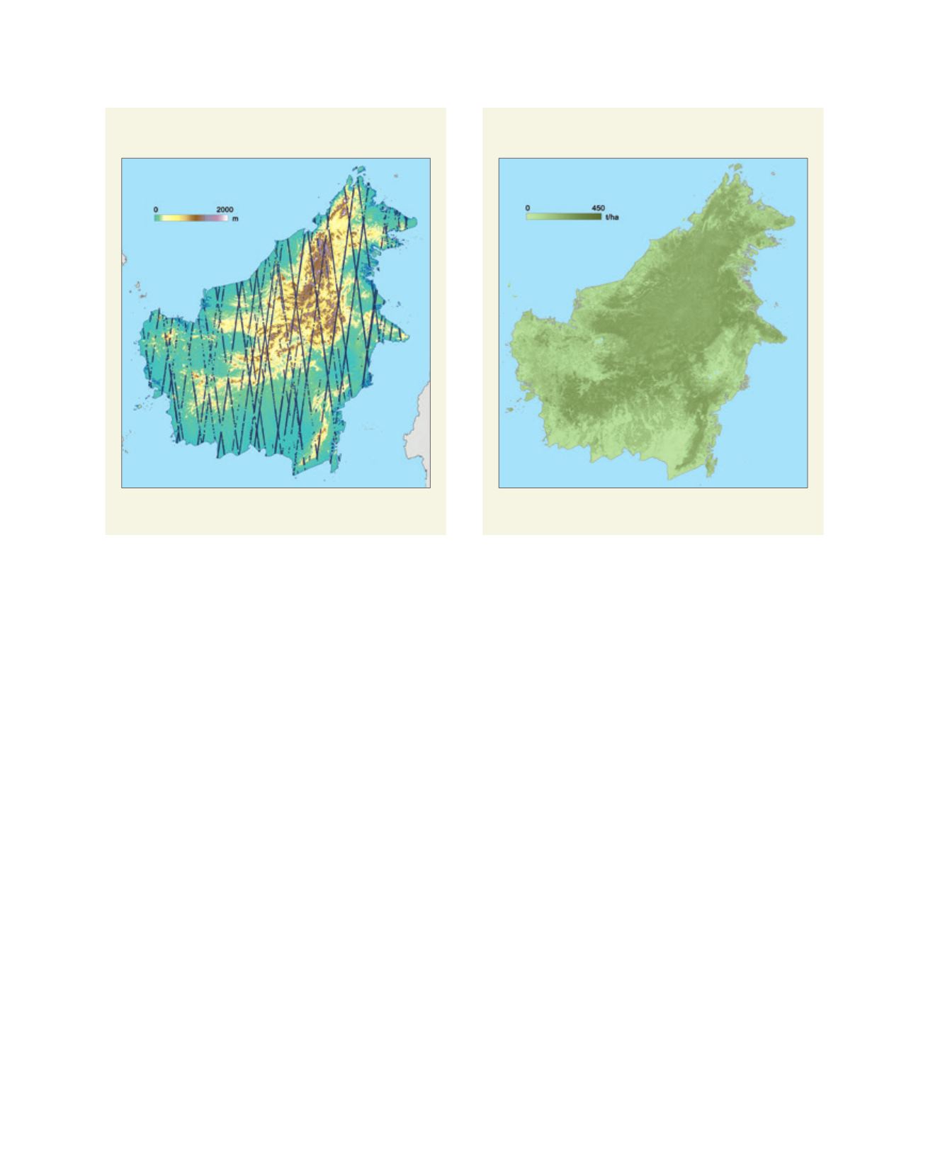
We applied the estimation models of canopy height and
AGB to the GLAS data in the whole of Borneo. After exclud-
ing data on cloud-covered measurements and non-forested
areas, we obtained 127,862 data points that were valid for the
analysis. Field measurements at 127,862 plots would require
a great deal of labour, so using satellite data is an efficient
method for collecting information on forest resources. The
results of estimating canopy height and AGB from the GLAS
data showed that the average canopy height was 17.3 m, and
the average AGB was 191.8 t/ha over Borneo. Furthermore,
we created AGB histograms for each province to compare
the distribution of forest resources. In Brunei Darussalam,
the forests were found to have high AGB because of the
many forest reserves. The forests in Kalimantan Utara and
Kalimantan Timur, in the eastern part of Borneo, also had
a high AGB. By contrast, in Kalimantan Barat, Kalimantan
Tengah and Kalimantan Selatan, in the southern part of
Borneo, relatively low-AGB forests were found. Finally, in
Sabah and Sarawak, in the Malaysian part of Borneo, forests
with a wide range of AGB were distributed.
Next, we divided the GLAS data into two groups accord-
ing to their observation period, and we estimated the rate
of forest loss between the two periods by identifying GLAS
data for non-forested areas (estimated canopy height < 2
m). As a result, the forest loss rate was 2.4 per cent per
year during three years from 2004 to 2007. The rate in the
Malaysian part of Borneo was 1.4 per cent per year and
A forest biomass map of Borneo (500-m resolution)
The distribution of GLAS footprints in Borneo
Source: CGER
Source: CGER
Aboveground biomass
SRTM elevation
L
iving
L
and