


 37 / 280

[
] 37
National priorities for building and implementing
GEOSS are driven by long-term political and societal
challenges that can benefit from internationally coordi-
nated earth observation activities. During the current,
initial phase of building GEOSS, fundamental cross-
cutting issues of the system architecture and data policy
must receive the appropriate attention. User engagement
at different levels (eg federal agencies, Länder agencies,
EO service industry) is viewed as equally fundamental
to the long-term support and ultimate success of GEO.
At a technical level we try to ensure that the data and
information standards and protocols implemented for
INSPIRE or the German national spatial data infra-
structure (GDI-DE), which conforms to INSPIRE, feed
into the work of the relevant GEO tasks to ensure
compatibility. This is achieved primarily by the personal
involvement of the experts tasked with setting up the
GDI-DE in the GEO architecture tasks.
Several of the national data policies will need to be
reviewed over the coming months and years for imple-
menting INSPIRE and GMES, in particular. GEOSS will
likely encourage a broadening of this discussion at the
national level.
Activities to engage additional users in Germany have
been initiated by the national GEO secretariat and it is
likely that this will be pursued even more vigorously
after the national GEOSS implementation plan has been
published. Again, these activities can build on and often
coincide with user engagement for GMES, thus ampli-
fying its effectiveness.
Germany was actively involved in the preparation of
GEO’s 10-Year Implementation Plan (TYIP) and its more
states (
Länder
), their potential contributions, needs and requirements.
During 2007 D-GEO drafted a national GEOSS implementation plan
(DGIP) that will be presented to the government during 2008. A
strategic summary will be available before the end of 2007.
The main objective of this implementation plan is to present national
priorities and recommend a strategy for realizing GEOSS benefits
through concrete steps. A national GEO secretariat has been set up to
coordinate the German participation in the GEO committees and
federate the involvement of key national stakeholders. Through its
coordination of the D-GEO group and national information activities
the D-GEO secretariat has been very successful in raising the profile
of GEO in Germany. German institutions and experts are contribut-
ing to well over 50 of the 72 tasks in the current work plan, directly,
and indirectly through international participating organizations. Many
of the most important German contributions to GEOSS are made
through European and international programs and initiatives.
At the international level Germany contributes among others to
the Global Observing System (GOS) of the World Meteorological
Organization (WMO), and the Global Ocean Observing System of
the International Oceanographic Commission (IOC) of UNESCO.
At the European level it contributes for example to the Global
Monitoring for Environment and Security (GMES) program, activi-
ties in the context of the European directive for establishing an
Infrastructure for Spatial Information in the European Community
(INSPIRE), the earth observation satellite programs of the European
Space Agency (ESA), and the European Organisation for the
Exploitation of Meteorological Satellites (EUMETSAT).
These projects highlight that the principal framework of Germany’s
involvement in GEO is a European one. The German participation
in GEO and contribution to GEOSS uses the available European and
other international mechanisms and institutions where this is possi-
ble and effective.
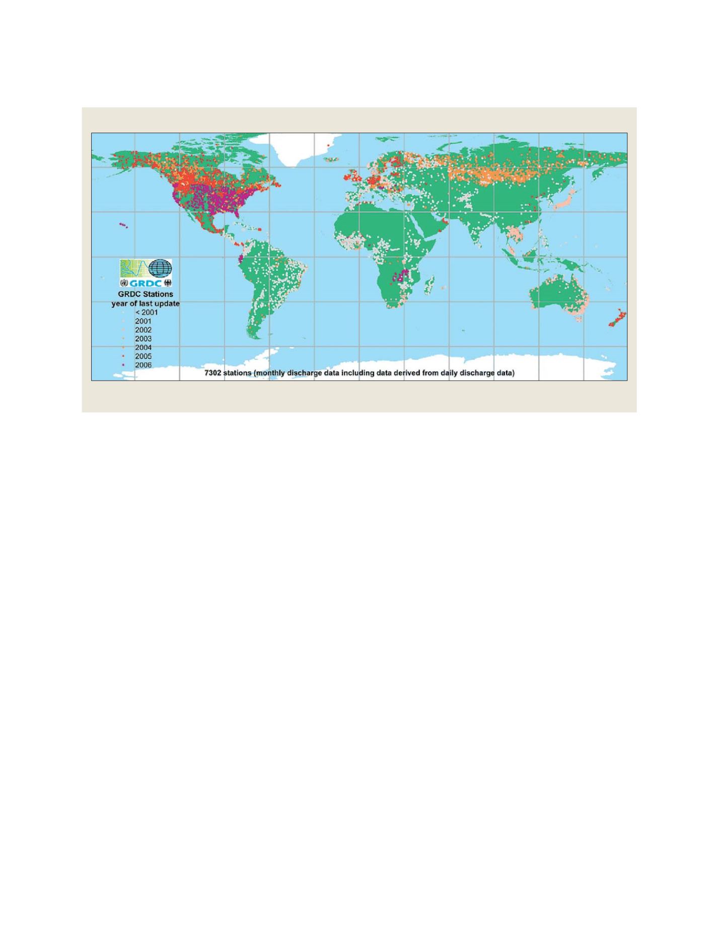
Global Runoff Data Centre
The Global Runoff Data Centre, operated by BfG, collects stores, and disseminates discharge data from rivers around the world
Source: Global Runoff Data Centre
N
ATIONAL
& R
EGIONAL
R
EPORTS