


 186 / 192

[
] 186
disaster. Such considerations, and the UNDDD, have helped
USM to refocus attention on land use and land degradation
under sustainable development. Malaysia and its universi-
ties are an active part of national efforts to manage land and
land resources sustainably.
14
The disaster risk management
for sustainable development (DRM-SD) model, developed
by USM and the Centre for Global Sustainability Studies
(CGSS), shows such an approach.
There follows a description of USM’s research efforts
towards risk-reduced land use by addressing potential
negatives and turning them into positives that promote
sustainability. In order to address land degradation and
risk management within the context of this article, we have
identified four specific areas: rainfall and land erosion; risk
assessment; slope monitoring; and slope stability software
where the authors (Fauziah Ahmad and Ahmad Shukri
Yahaya) have played lead roles. Although these projects
have focused on land management issues of Penang state in
Malaysia, the methodologies used and the results obtained
have much wider applications.
Rainfall erosivity — the ability of rainfall to cause erosion
due to its physical characteristic — is increasingly used for
soil erosion risk assessment for current and future, espe-
cially under a changing climate. Land management models
use rainfall amount and intensity as key factors.
15
The effect of rainfall erosivity in Penang was considered
for two stations, Air Itam and Simpang Ampat. Monthly as
well as annual rainfall data, obtained from the Department
of Drainage and Irrigation, Malaysia for 30 years (1983-
2012) was used to calculate the mean and standard
deviation per decade.
The coefficient of variation is less than 0.3 for all
stations, showing that the mean rainfall has very small
variability although the regression line shows a slightly
moderate positive trend. Mann-Kendall trend analysis and
Sen’s slope tests were carried out to establish the decadal
mean monthly rainfall variability. The Fournier indexes
were used to determine the effect of extreme rainfall events
towards soil erosivity. Air Itam recorded 10 per cent cases
of very severe impact using the Fournier index and 3.33 per
cent cases of very high impact using the modified Fournier
index. This shows that while Air Itam is susceptible to soil
erosion due to rainfall events, Simpang Ampat is more
prone to landslide.
16
Penang has a corrugated and hilly topography.
Construction activities in these areas are increasing primar-
ily for residential and commercial purposes. Assessing the
extent of the corresponding development risk is critical to
the life and property of local inhabitants. Using 13 variables
such as slope gradient, soil profile, rock quality designation,
plastic index, shear strength of coarse and fine grained soil,
groundwater monitoring, land-use suitability, slope stabili-
zation measures, slope stability analysis, rock fall analysis,
retaining and foundation system, soil erosion and sedimenta-
tion control and maintenance monitoring, the authors have
modified existing rating systems to arrive at a methodology
to assess the overall risk thresholds for landslides.
USM’s main campus in Penang has an aesthetically beau-
tiful and hilly terrain. As part of its commitment to be a
sustainability-led university, a pilot slope-monitoring study
was conducted by a group led by the authors to monitor
and mitigate USM’s hillside hostels. The Well-Inform
Landslides Monitoring System (WILMS), a real-time web
monitoring system, was developed which integrates the
use of Short Messaging Services and Multimedia Messaging
Services technology to disseminate results.
17
Based on the on-site data collected without needing
constant manual intervention, WILMS forecasts when land
instability is more likely to occur. Such data eventually
form the basis on which WILMS outputs are computed.
WILMS’ capacity to establish secure communication with
users while preserving proper data transfer between data
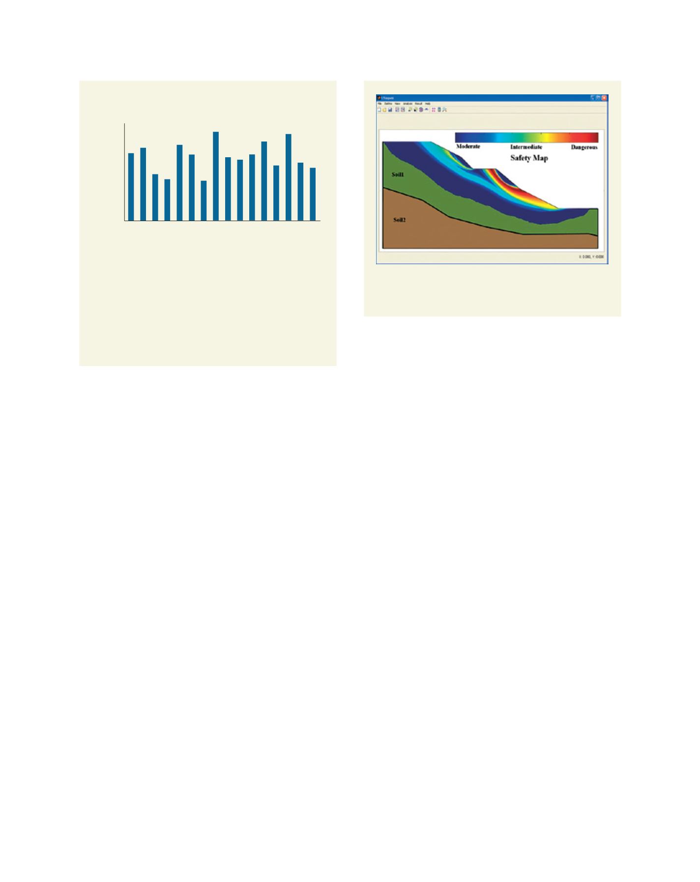
Environmental risk by project
The graph shows the results applying the authors’ methodology
to 16 selected project sites, P1-P16, which are also landslide-
prone hillside development sites in Penang. The results show that
12 per cent of project sites were at high environmental risk, 44
per cent at medium risk and others at low risk.
20
The results are
used to develop the guidelines for slope land use and sustainable
management by the Penang State Government.
Source: USM
4.00
3.50
3.00
2.50
2.00
1.50
1.00
0.50
0.00
Project ID
Environmental risk (rating)
P1
P2
P3
P4
P5
P6
P7
P8
P9
P10
P11
P12
P13
P14
P15
P16
Typical output of Safety Map Analysis using USlopeM
TM
software
Source: USM
L
iving
L
and