


 187 / 192

[
] 187
acquisition tools, servers, computers and mobile devices
via wired and wireless is one of its unique properties. It
also has an alarm system that is triggered when changes are
detected in the geotechnical parameters of the slope that
exceed the safety limit.
Although developed for the USM Kampus Sejahtera
(Healthy Campus) Programme (2000), WILMS is a handy
tool to alert slope stability managers when remedial meas-
ures are deemed necessary.
Evaluating the stability of slopes is a big challenge for
geotechnical engineers. It involves locating the slip surface
with the minimum factor of safety (FS). An in-depth study
revealed that most of the current commercial slope stabil-
ity software suffers from poor search algorithms, resulting
in over-estimation of stability. Considering this limitation,
USlopeM
TM
was developed which employs state-of-the-
art metaheuristic search algorithms to locate critical slip
surfaces to determine the minimum FS that indicates
probable slope failures. USlopeM
TM
addresses the possi-
ble existence of multiple, rather than single failure modes.
Currently, engineers have to run commercial software
several times using different initial parameters to locate
all important slip surfaces. USlopeM
TM
finds all global and
local minima of FS in a single run without significant reli-
ance on engineering experience. The software is released
with a CAD-like graphical user interface for creating slope
models and viewing results. It also uses parallel comput-
ing to exploit the full performance of multi-core central
processing units. The major end product of the analysis
is a Factor of Safety Map which will indicate the region of
critical area in just less than a minute.
18
The software has obtained copyright and trademark
and has also won gold medals at the 25th International
Invention, Innovation & Technology Exhibition in Kuala
Lumpur; at the Belgian International Trade Fair for
Technological Innovation in Brussels; and at the Korea
International Women’s Invention Exposition in Seoul.
USM is at the forefront of research and capacity-building
within its renewed vision for an all-institution mainstream-
ing of sustainability. This finds expression in campus
sustainability promotion on the one hand and integrating
global sustainability principles and practices, as articulated
through the Rio process, on the other. Within this priority
we have focused this discussion on land use issues relat-
ing to slope land erosion and slope failures. Considering
the impact of rainfall, new development and other emerg-
ing issues that increase the vulnerability of slope lands, we
have highlighted risk assessment as a way to monitor slope
strength. A new slope stability software, USlopeM
TM
, has
been developed at USM to generate slope stability scenar-
ios for risk-reduced land use. Through research, training
and community based initiatives, USM will continue its
UNCCD focus. After all, desertification represents the
acute convergence of a wide range of challenges that must
be faced globally — poverty reduction, economic growth,
food security, climate change, land use, water manage-
ment, good governance and the achievement of Sustainable
Development Goals.
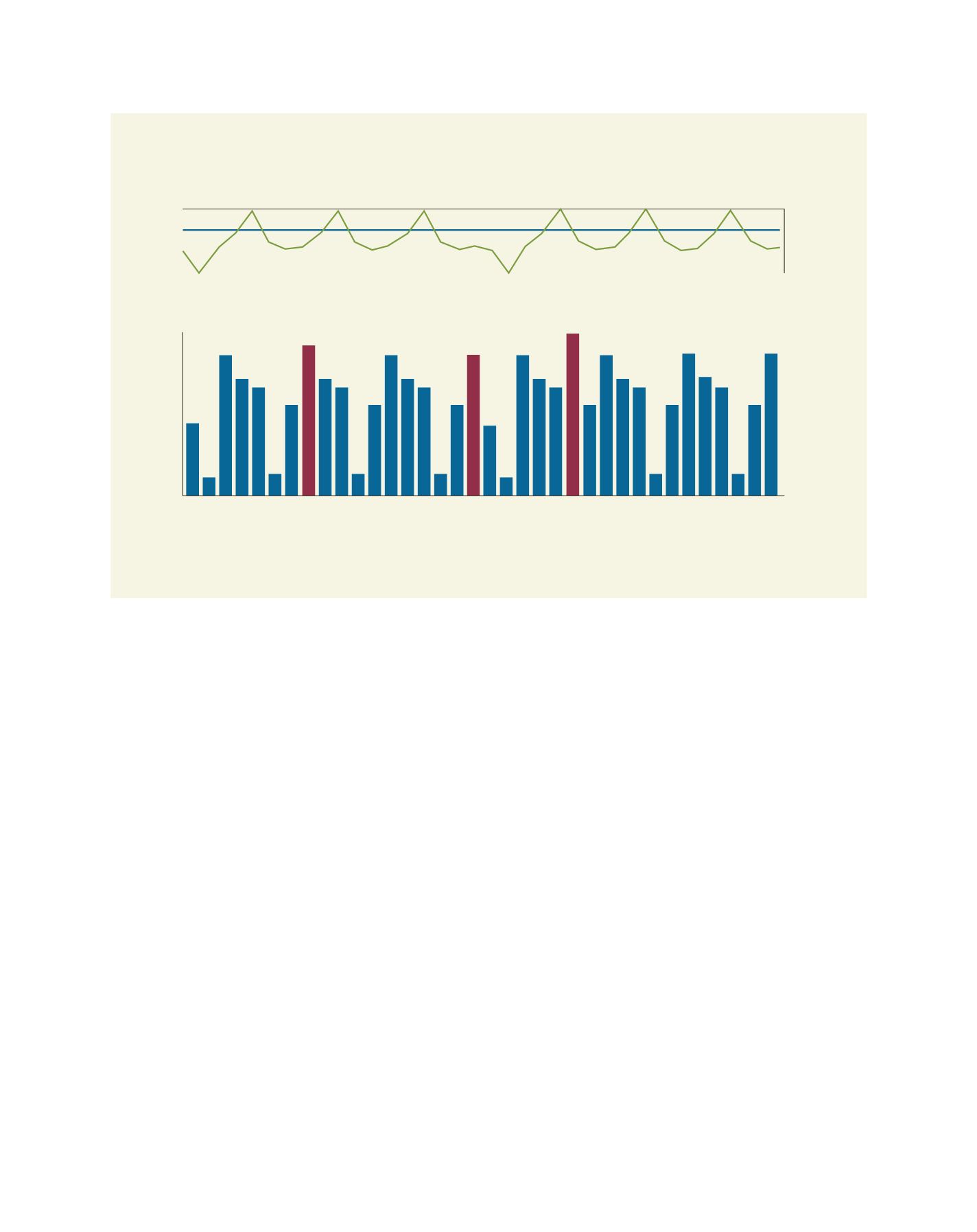
Result from WILMS on rainfall amount and pore water pressure over a certain monitoring period
Rainfall (mm)
Pore water pressure (mH
2
O)
1,140
1,160
1,180
1,200
1,220
1,240
1,260
1,280
1,300
1,180
1,220
1,260
col2
J 03
J 03
J 03
J 03
J 03
J 03
J 03
J 03
J 03
J 03
J 03
J 03
J 03
J 03
F 03
F 03
M 03
M 03
M 03
M 03
M 03
M 03
M 03
M 03
M 03
M 03
M 03
M 03
M 03
A 03
A 03
A 03
A 03
A 03
A 03
col2
col2
col2
col2
col2
col2
col2
col2
col2
col2
col2
col2
col2
col2
col2
col2
col2
col2
col2
col2
col2
col2
col2
col2
col2
col2
col2
col2
col2
col2
col2
col2
col2
col2
col2
J
J J
J J
J J
J
J J
J J
J J
F
F
M M M M M M M M M M
M M
M M
A
A
A
A
A
A
Source: USM
L
iving
L
and