


 183 / 288

[
] 184
T
ransport
and
I
nfrastructure
that the port operator could take to increase the resilience of
its activities and assets over the coming decades.
There are a number of ways ports could be affected by
climate change. Risks will depend on the location (for
example, tropical or extra-tropical, areas with permafrost
or sea ice, lakes or rivers) and functions of ports (such as
cargo handling, warehousing, pilotage, dredging or passen-
ger cruises). Thanks to its location on a natural harbour,
MEB is relatively sheltered from harsh climatic and oceanic
conditions. As such, overall there are only a small number of
ways that MEB’s performance could be significantly affected
by climate change. These include:
• Reduced vehicle movements inside the port due to
seawater flooding
• Decreased global trade and US grain exports to
Colombia affecting MEB’s cargo transport revenues
• Increased risk of damage to goods stored in the port
due to flooding
• Degradation of mangroves around the port.
Other ports around the world could suffer a wider range
of risks associated with a changing climate.
Of all these expected climate change impacts,
flooding due to local sea level rise constitutes the
most serious issue for the port. Following the study,
the port announced that it would invest in additional
flood protection.
Project details
MEB is the second-largest port in the bay of Cartagena
in Colombia. Although it benefits from one of the most
secure locations on Colombia’s Caribbean coast, offering
natural shelter from high winds, high waves and storm
surges, MEB remains exposed to some of the effects of
climate change, such as sea level rise, increased rainfall
intensity and warmer temperatures.
Experts from the University of Oxford in the UK and
Universidad Nacional de Colombia assisted the team in
analysing observed climate variables and trends, as well
as climate model projections for the Cartagena region.
Climate and ocean observations clearly show that climate
change is already underway in Cartagena, where average
temperatures have risen by more than 0.7° C since the early
twentieth century, precipitation has become more intense,
and sea level has been creeping up at a rate of 5.6mma year.
However, there is a dearth of local data about short-term,
extreme weather and oceanic events such as gust winds,
heavy downpours or storm surges. Climate data analysis
is complicated in countries like Colombia by the fact that
there is so far little agreement between climate models over
future precipitation, due to complex local topography and
the lack of understanding of how tropical cyclones may
change in the future.
To overcome these limitations, the study relied on
different sources of climate data to explore a wide enve-
lope of plausible changes in climate. Where outputs
diverge between different datasets or methods, a set of
climate scenarios was considered in the risk and adapta-
tion assessment.
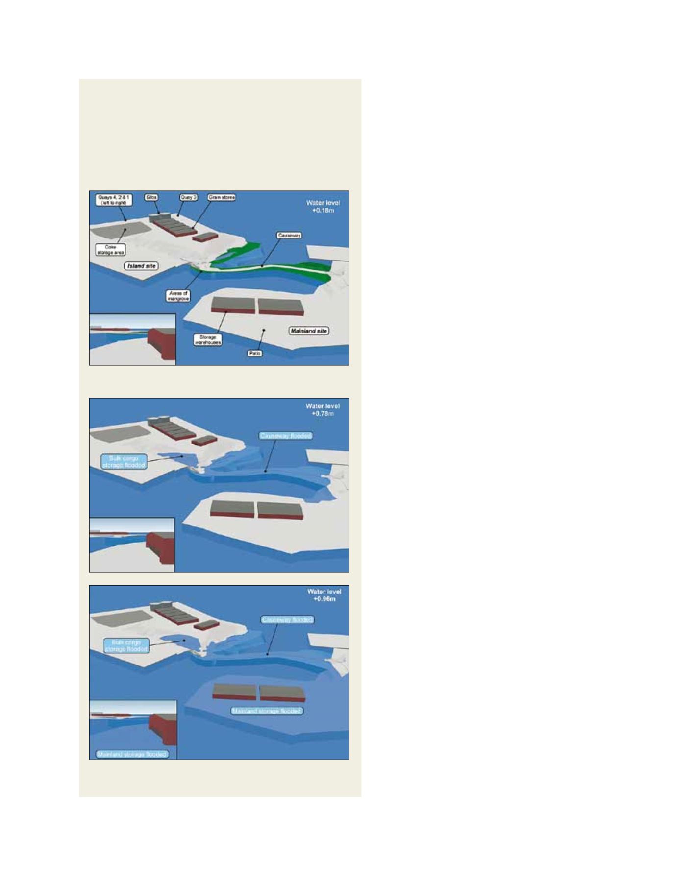
Interruptions to vehicle movements due to seawater flooding of the port
• Lowest area: causeway linking mainland and island sites (0.6m above port
plan datum)
• Causeway projected to flood at highest tides by 2018 and 2015 (observed
and accelerated SLR scenarios).
• Mainland patio and storage warehouses projected to flood at highest tides
by 2070 and 2050 (observed and accelerated SLR scenarios).
• Quays not projected to flood.
Source: International Finance Corporation
Projected flooding (areas in blue) during highest spring tides and highest water
level in 2050 in the observed (middle) and accelerated (bottom) scenarios
Mean sea level at MEB in 2000