


 163 / 287

[
] 164
O
bserving
, P
redicting
and
P
rOjecting
c
limate
c
OnditiOns
specifications. Such modelling should inform more long-range urban
management applications, such as definition of lands that will be at
risk of flooding and are to be covered by a hazard setback ordinance.
For other sorts of climatological phenomena, while climate change
projections generally agree, taking action seems to be a low priority for
local decision-makers. This is the case with addressing projected heat or
cold waves, as well as mean temperature rise. While responses such as
modernized building codes are possible, to date suchmeasures have not
attracted priority attention in the CCCI countries. This is because other
issues such as flooding are seen as more urgent – despite the real havoc
that heat or cold waves can cause (the heat wave that struck western
Europe was blamed for killing more than 35,000 people). At present
none of the pilot cities are planning to undertake more sophisticated
localized modelling of temperature change, such as taking into account
radiation from asphalt and paved surfaces.
Implications for the World Meteorological Organization
and partners
Research leading to a higher level of convergence among projections
is a priority. This is particularly the case where localized projections
disagree as to the direction of change, as the CCCI team
in Esmeraldas found with projections for mean precipi-
tation. However, different models will always yield
somewhat different results, so increased capacity-build-
ing for officials and urban managers as to how best to
pick and choose between conflicting projections when
this issue materializes would be of great assistance.
Establishing and operating meteorological stations that
collect data of adequate quality and quantity is impor-
tant. Several decades of trends of changes in temperature,
rainfall, mean sea level and similar phenomena help
local decision-makers to convince a sceptical public
about the risks. They also serve as an important refer-
ence point when taking up regional climate projections.
Furthermore, local weather stations need to be able to
support urban or river basin-level hydrological modelling
with adequate data. Efforts at local modelling and subse-
quent risk and vulnerability mapping run into difficulties
if only one local station is actively collecting data, and
where daily but not hourly rainfall data are available.
13
Some actions, fromthe perspective ofmid-sized cities in the
developingworld, appear to be of lower priority. Researchers
suggest that much work remains to be done to generate site-
specific urbanized data, by developing advanced models
based on computational fluid dynamics.
14
However, to the
CCCI cities such sophisticatedmodelling (particularlywhere
the outputs would focus primarily on improved projections
ofmean temperature andheat waves)would be a lower prior-
ity than an improved hydrological model of the city. This is
because a family will be more concerned as to whether their
house will be swept away due to flooding than about a more
precise projection of future temperature rise.
Future scenarios
In an uncertain world, local officials and planners crave
certainty upon which to base decisions. Where such
certainty is not possible – as it rarely if ever is – officials at
least desire clear future scenarios that they can understand
and explain to constituents. When making decisions plan-
ners have often sought out vulnerability assessments based
on a clear future scenario (a 100 year flood event), rather
than full-blown probabilistic analyses of various risks.
Full-scale risk analyses have not been used extensively for
planning purposes, possibly because planners and local
officials are less familiar with these concepts and methods,
and because of the relative paucity of land use manage-
ment tools based on risk rather than vulnerability.
15
This preference for certainty is as deeply, if not more
profoundly, felt in the new and relatively unfamiliar
terrain of climate change. UN-HABITAT welcomes
the recent surge of interest in the urban dimension of
change, for example the upcoming IPCC Expert Group
Meeting that will take up the topic, and a special report
on human settlements being prepared for the IPCC’s
fifth annual meeting. UN-HABITAT’s hope is that such
research will lead to projections that are more useful to
practitioners at the city level, and that will allow plan-
ners to embrace a fuller range of tools to address climate
change in all of its various manifestations.
16
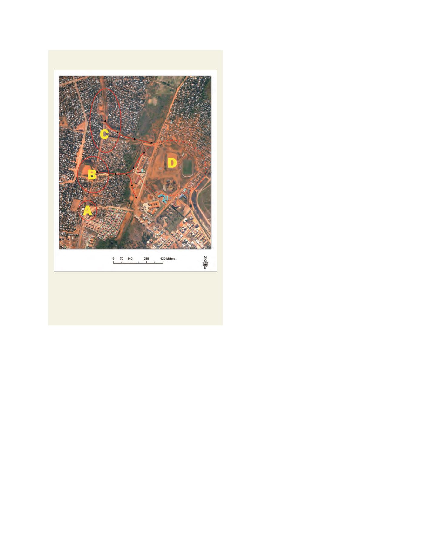
Detailed mapping of road interruptions and damages along
Avenue Julius Nyerere, Maputo
Source: UN-HABITAT, Climate change assessment for Maputo, Mozambique, 2009
A: New trajectory of Avenue Julius Nyerere and alternative way to Avenue
Marginal Maputo. B: The point where the bridge fell down and evident source of
soil erosion during the rainy season. C: Second point of the avenue interrupted.
Pavement damaged and source of soil erosion during the rainy season. D:
Confluence zone of material, soil erosion and water during the rainy season and
infrastructures of Costa do Sol Stadium use to be affected