


 35 / 336

[
] 35
The Nile Basin Initiative: advancing transboundary
cooperation and supporting riparian communities
Abdulkarim H. Seid, Wubalem Fekade, Emmanuel Olet, Nile Basin Initiative
T
raversing a distance of 35 degrees latitude from the equa-
torial region of Africa in the south to the Mediterranean
Sea in the north, the Nile is one of the world’s longest
rivers. It is shared by 11 African countries and is a source of
livelihood for over 200 million people. The Nile drains an area
of 3.2 million square kilometres – about 10 per cent of Africa.
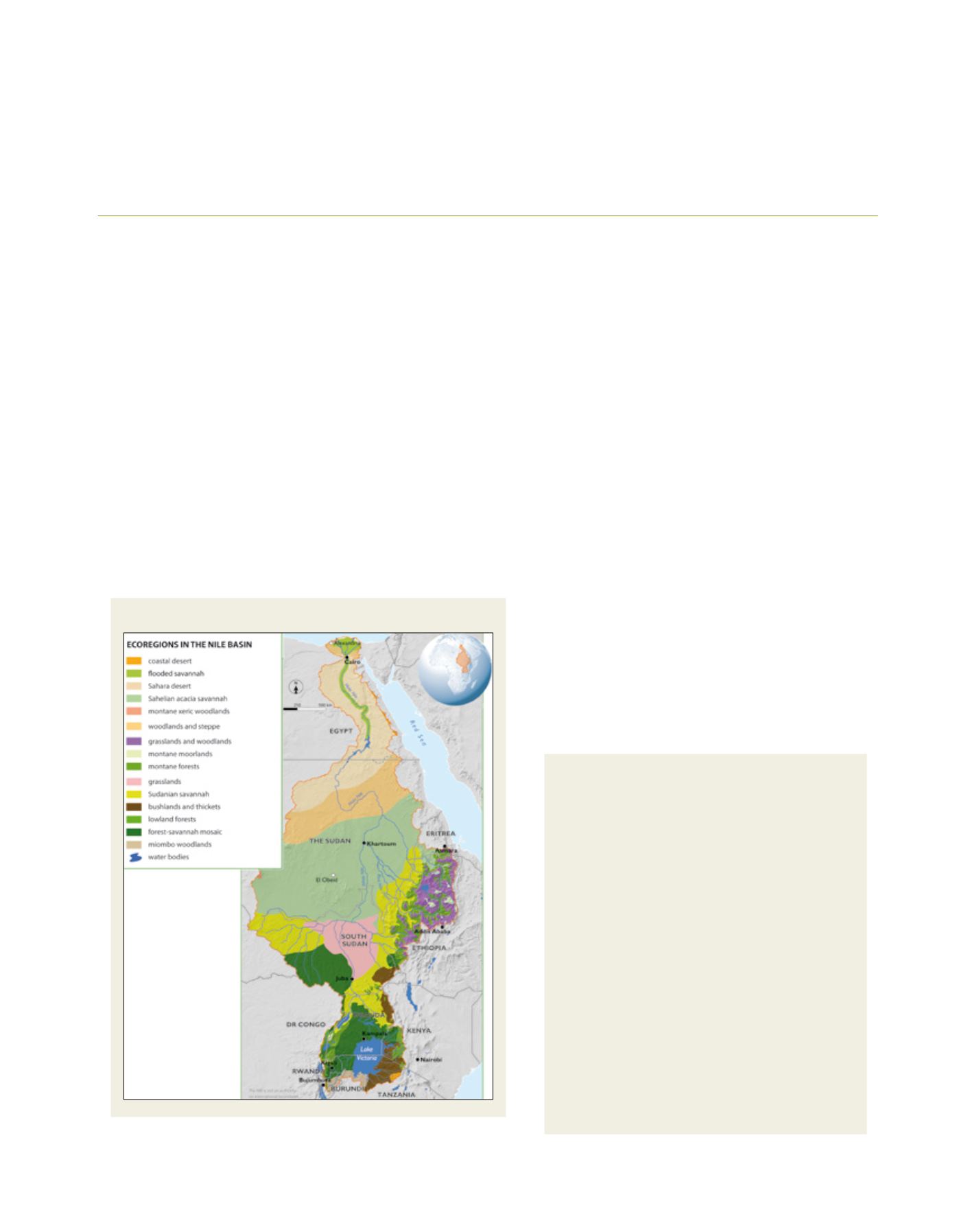
The Nile Basin Initiative (NBI) 2012 State of the Nile River Basin
report subdivides the basin into 16 eco-regions. These feature large
rivers, waterfalls, lakes, wetlands, floodplains, forests, savannahs,
montane ecosystems, and arid and hyper-arid lands. One of the
world’s largest freshwater wetlands, the Sudd, and the world’s second
largest inland lake, Lake Victoria, are prominent features of the basin.
The Nile Basin hosts some of the world’s largest congre-
gations of large mammals and flocks of migratory birds
from Eurasia and other regions of Africa.
The Nile Basin is a relatively water-scarce region. The
average annual flow at its entrance to Egypt is about
2,660 m
3
/s – about 6 per cent that of the Congo River
at Inga. Most of the stream flow is generated from less
than a third of the basin. The basin is prone to seasonal
and inter-annual variability. Water resources develop-
ment is needed at the upstream part (comprising seven
of the 11 riparian countries) where nearly all river flow
is generated is at its infancy. The downstream part
(comprising two riparian countries), is almost entirely
dependent on upstream flow and has relatively better
developed water infrastructure and institutions.
The Nile Basin has hosted some of the oldest civiliza-
tions of mankind. That notwithstanding, currently the
Nile River and its associated ecosystems – the resource
bases – are facing a number of threats. In the upper
reaches the watersheds are undergoing continued and
accelerating degradation. From the Ethiopian catchments
alone where over 86 per cent of the river flow originates,
W
ater
D
iplomacy
The Nile Basin eco-regions
Source: NBI State of the Basin report, 2012
Tana-Beles integrated watershed management
project – Ethiopia
The Eastern Nile watershed management project has
built a regional knowledge base which has been used to
prepare fast-track projects worth about US$80 million.
One of these projects, in the upper Blue Nile in
Ethiopia, has scored impressive results in natural
resources management, improving the livelihoods of the
local community, and capacity development.
Examples include the preparation and implementation
of 163 community watershed plans; treatment of 821
ha of gully; rehabilitation of 16,000 ha of degraded
hillside; development of 4,000 ha of community woodlot
forestry; and 1,000 ha of small-scale irrigation in 14
schemes. In addition, 85 km of community access
roads and a number of footbridges were constructed to
improve market access; and 35 farmer training centres
were established – with about 700 farmers trained on
improved cereal, fruit tree cropping, vegetable gardening
and marketing. The project also established 13 animal
health posts; supplied 735 modern beehives and
163 pieces of apiculture equipment; and established
432 community water points and three village water
schemes. The project is among the NBI achievements
showcased during the 2013 Nile Day celebrations.