


 110 / 280

[
] 110
GEONETCast: nerve system for the planet
Linda Moodie, US National Oceanic and Atmospheric Administration;
Michael Williams, EUMETSAT; Fan Jinlong, China Meteorological Administration
T
he well-being of the human species directly depends on the
health and condition of the Earth. GEONETCast is a mile-
stone in the dynamic and developing Global Earth
Observation System of Systems (GEOSS), which endeavours to
bring together the many disparate sources of environmental infor-
mation, so that it can be directly applied in efforts to remedy
today’s pressing problems.
In recent years, scores of satellites and thousands of sensors on land,
in the sea, and in the atmosphere have been deployed to gather infor-
mation on every aspect of the environment. GEONETCast helps to
improve the global availability of this information. The network trans-
mits information on climate, crops, water quality, air pollution and
more.
Conrad Lautenbacher, under secretary of commerce for Oceans and
Atmosphere and US co-chair of the Group on Earth Observations
(GEO) says: “The aim of GEONETCast is to put timely information
into the hands of those who most need it, so they can make the right
decisions about some of the most important problems facing our world
today. It is a shared effort, and the entire world will benefit.”
What is GEONETCast?
GEONETCast is a low cost, global, environmental information deliv-
ery system. Satellite and in situ data, products, and services fromGEOSS
are transmitted to users through communications satellites using a
multicast, access-controlled, broadband capability.
The communications satellites allocated to each sector of the globe
are provided by the GEONETCast partners, individually, or as a group.
The current coverage is based on contributions from the
European Organisation for the Exploitation of
Meteorological Satellites (EUMETSAT), the United States
(National Oceanic and Atmospheric Administration) and
the China Meteorological Administration. Russia has also
indicated an interest in providing coverage in Eur-Asia. In
addition, the World Meteorological Organization is acting
as a GEONETCast partner by contributing its experience
in coordinating globally interoperable telecommunication
systems, including satellite broadcast services, for weather-
related information.
The day-to-day management of each global sector is the
responsibility of each respective regional satellite broad-
cast provider. The regional components include one or
more data collection, as well as management, and dissem-
ination centres that receive, process, prioritize, and
schedule the incoming data streams or products. In addi-
tion to the existing dissemination centres, GEONETCast
also encompasses the exchange of data between the
various centres.
Communication satellite providers broadcast using a
standard protocol interface, such as is used for direct-
to-home television transmission. Different data streams
or products could be made available on separate chan-
nels. The user decides which data are to be received,
managed, and saved locally. No Internet connection is
required, and the receiving station is simply a standard
personal computer, an off-the-shelf satellite television
dish and a couple of computer cards. The total cost
amounts to approximately euros1,500 or USD2,000. The
result is expanded dissemination of urgently needed
environmental data to users located anywhere on the
planet, automatically 24 hours a day.
GEO’s added punch
Data access and utilization are key issues to every partic-
ipant in GEO. Without improved access, delivery, and
sharing of Earth observation data and products, the
intended applications for enhanced benefits to society
will not materialize, particularly in developing coun-
tries.
At its second plenary in December 2005, GEO
adopted the concept of GEONETCast and added it to
its work plan. GEO recognized that GEONETCast could
add value to existing operational and research efforts by
expanding the delivery of data and information to users,
particularly those in developing countries, at a reason-
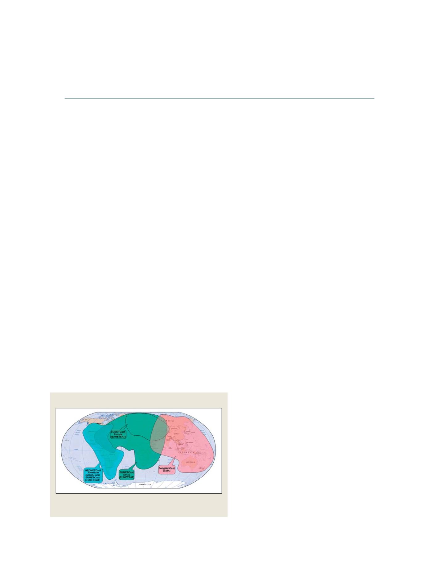
Global GEONETCast Coverage
GEONETCast partners provide communication satellite coverage for
dissemination of environmental information to sectors of the globe
Source: EUMETSAT and NOAA
GEOSS C
OMPONENTS
– D
ISSEMINATION
/I
NFORMATION
S
YSTEMS