


 115 / 280

[
] 115
available community portals accessible from the
GEOPortal. These community portals are serving partic-
ular regions and/or are specific to a GEOSS SBA and
related user scenarios. Initial contributions comprise:
Argon/IM; the German Federal Agency for Cartography
and Geodesy (BKG); European Community Joint
Research Centre (EC/JRC); US Federal Geographic Data
Committee Secretariat (FGDC); Global Biodiversity
Information Facility (GBIF) in collaboration with
GeoConnections, Global Earth Observation and
Monitoring (GEOmon); George Mason University
(GMU); Ecole des Mines de Paris; National Aeronautics
and Space Administration (NASA); San Diego
Supercomputer Center (SDSC), and the Regional
Visualization and Monitoring System (SERVIR).
In addition, three contributions have been provided for
establishing, hosting and operating a GEOPortal inter-
connecting the community portals and thus serving as an
entry point into the GEOSS. Contributions comprise
Compusult, Environmental Systems Research Institute
(ESRI) and the European Space Agency (ESA) in coop-
eration with the Food and Agriculture Organization
(FAO) of the United Nations.
The ESA/FAO contribution to the GEOPortal has been
designed to be part of the Initial Operating Capability of
GEOSS, including an initial funding for operations for
the duration of the current GEO 2007-2009 workplan.
Its quality of service is equal to that of ESA’s Earth obser-
vation user services, and includes the maintenance of
information content and software.
A clear concept for the GEOPortal and its place within
the GEOSS architecture have been established.
Accordingly, the GEOPortal system and its user interface
have been implemented and a number of contributions to
the GEOPortal, and community portals have been inter-
connected and are today part of an initial operating
capability of GEOSS. Operations for an initial period until
2009 have been secured, and the GEOPortal is now open
to serve the GEOSS and to further evolve, taking into
account the requirements of its users.
lying GEOPortal system, but include the maintenance of information
contained locally within the GEOPortal and ensure the consistency
of the links and interfaces to GEOSS. Local information may include
up to date sample data sets representative of the different SBAs.
Optionally, the GEOPortal may consider whether to provide value-
adding services in that its operators proactively identify and highlight
data and information, for example providing the latest data on the
propagation of avian flu under the ‘Health’ SBA. Specific agreements
with interested community portals may provide a framework for such
features.
With the number of components of GEOSS growing, operations also
need to ensure that any resources newly available to GEOSS can be
discovered by the GEOPortal. And with a growing user base, one
option would be to provide GEOPortal users with the option to pre-
configure the GEOPortal tailored for their access needs, making it their
MyGEOPortal (e.g. a portal automatically linking to a particular SBA
or world region).
In perspective, the GEOPortal may also be used for creating commu-
nity portals or individual portals if required by a GEO member or
participating organization. The GEOPortal software is based on a
number of open source modules which could be made available and
be configured to create, for example, a portal for the ‘Energy’ SBA.
The GEOPortal may provide additional information in support to
capacity building, either through selected information stored locally
or through access to a capacity building portal containing a compre-
hensive set of related material such as training documentation.
The need for such features will be assessed taking into account first
operational experience of the GEOPortal and user feedback. The level
of use of various elements of the portal will be assessed on a regular
basis to determine what kind of information is in greatest demand by
a given user community. This will ensure that the evolution of the
GEOPortal is targeted on areas of greatest need and use.
Status and next steps
At the time of writing, a number of GEO members and participating
organizations have established an implementation pilot and made
Source: www.geoportal.org
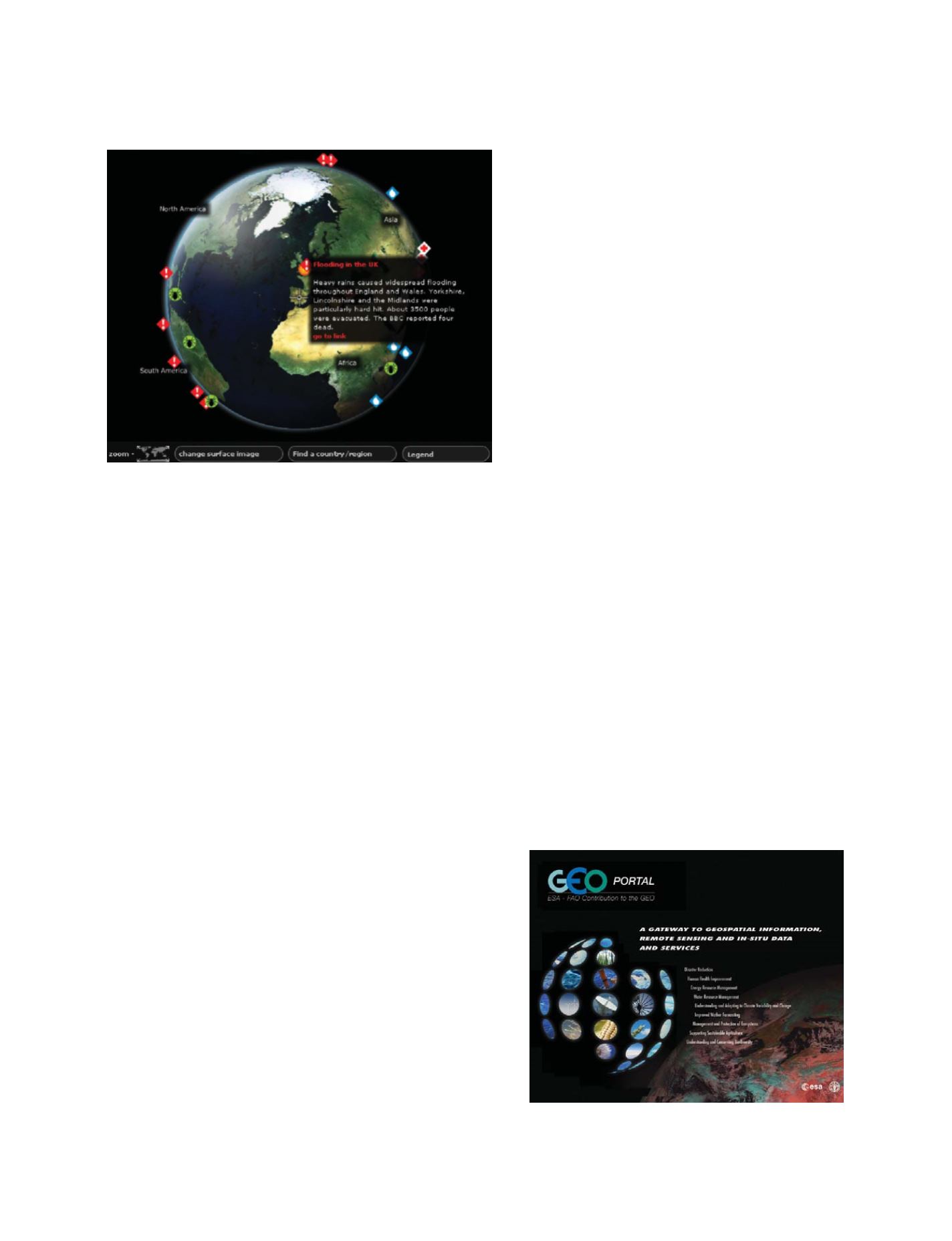
An example feed illustrating activation of the international charter ‘Space and
Major Disasters’ following flooding in the UK
Source: ESA/FAO
The GEOPortal is a gateway to geospatial information, remote
sensing and in situ data and services
GEOSS C
OMPONENTS
– D
ISSEMINATION
/I
NFORMATION
S
YSTEMS