


 126 / 280

[
] 126
The three core mapping service tasks are:
Land cover and land use
– At a local scale, it produces
very high resolution (VHR) urban atlas inventory and
change on European cities. At a continental scale, it
produces high resolution (HR) land cover inventory and
change (21 classes with 1-5 ha mapping unit).
Biogeophysical parameters
– In near real-time and off-
line, they describe the continental vegetation state, the
radiation budget at the surface and the water cycle.
Seasonal and annual change monitoring
– Operates at
continental scale over Europe and sub-Saharan Africa,
delivering an area frame sampling over permanent
samples (describing European and African environ-
mental/ ecological conditions for annual statistics of land
cover and land cover change), a complete continental
coverage of seasonal and annual vegetation parameters
to produce land cover, land cover change and agricul-
tural land use.
Seven core information services addressing impor-
tant sectoral policies and showing examples of GMES
end-to-end services are being set up with the following
aims:
Spatial planning
– Describe, explain and forecast
urban land use change in Europe.
Water
– Integrate Earth observation-derived land
cover/land use data in water quality models that can
contribute to water management in Europe in a flexi-
ble, sustainable and cost-efficient way.
Agri-environment
– Indicators assessing the impact of
agriculture on the environment and the effectiveness of
agri-environmental measures in Europe.
to the EC. The three components, local, continental and global, of the
Land Monitoring Core Service (LMCS) are to be addressed. The goal
of Geoland2 is to prepare, validate and demonstrate preoperational
service chains and products that will underpin the LMCS, as well as
proposing and demonstrating a concrete functional organisation for it.
Examples of agri-environmental services developed by Infoterra
In the longer term, GMES will also certainly monitor agriculture practices.
Even though agriculture’s share is decreasing, it still constitutes the largest
part of European budget (46 per cent in 2006). Agriculture was responsible
for 14 per cent of global greenhouse gas emissions in 2000 (source: WRI –
2006), with fertilizers the largest single source (38 per cent). The reform of
common agriculture policy and cross-compliance implies an increasing
importance for the monitoring of good agro-environmental conditions (GAEC).
Infoterra Group and its partners have validated specific services at a
regional level to support the water framework directive. This includes crops
inventory, irrigation monitoring and assessment of diffuse pollution.
These validation activities have demonstrated that relevant
information products can be readily implemented in various
regions and on a European scale. The services provide multi-
use information products and can also be integrated into GIS
systems, models and users’ decision support systems.
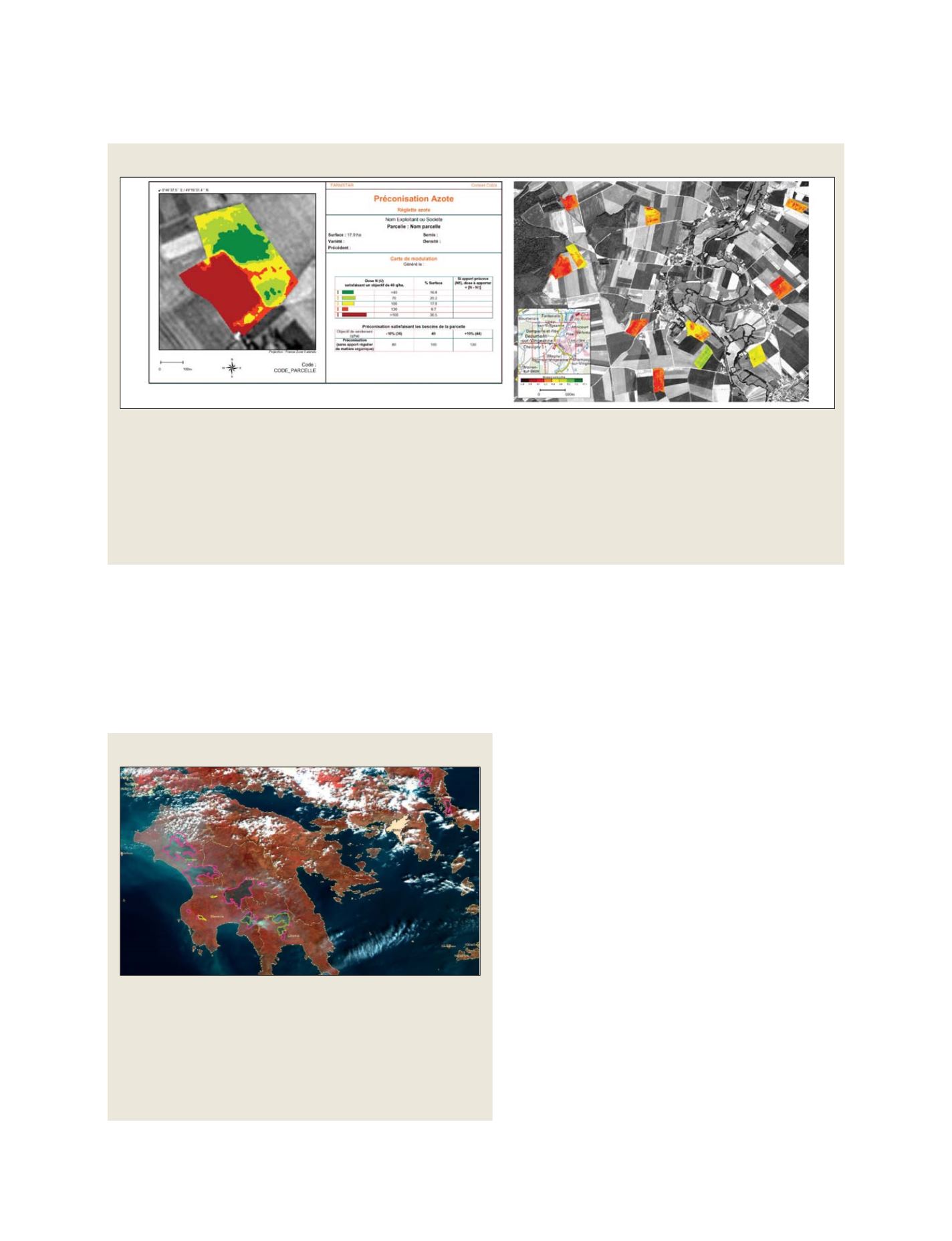
The picture above shows a typical FARMSTAR product,
developed by Infoterra. From this, commercial services can be
easily derived for similar applications within local or regional
management, better/optimised used of fertilizers and reduced
water pollution
Emergency response
Forest fires during the summer 2007 – validation of the operational capacity
Following the forest fires that raged across Europe during July and August
2007, Infoterra operated its emergency response services, in the frame of
GMES, and produced an assessment of the affected areas using imagery
acquired by SPOT and ENVISAT satellites.
A comprehensive assessment was produced on the 30th August 2007 of
the fires in the past week in the Peloponesian area. The main benefit here is
the revisit capacity of ENVISAT on large areas, very useful to monitor large
size events with a long duration
Source: Infoterra
Source: MERIS image ©ESA – Processing ©Infoterra
GEOSS C
OMPONENTS
– D
ISSEMINATION
/I
NFORMATION
S
YSTEMS