


 132 / 280

[
] 132
improved information on the state of Europe’s water
systems, and the trends and pressures they face.
The website focuses on:
• Water quality in rivers and lakes (nitrates, ammo-
nium, phosphates, ecological quality)
• European water bodies at risk or highly modified
• Regional information (My river basin)
• Urban waste water treatment
• European bathing water status.
WISE will be further developed according to the WISE
implementation plan. The approach will be to make use
of innovative technologies and to take a more decen-
tralized approach in accordance with the evolving
principles of the SEIS of Europe.
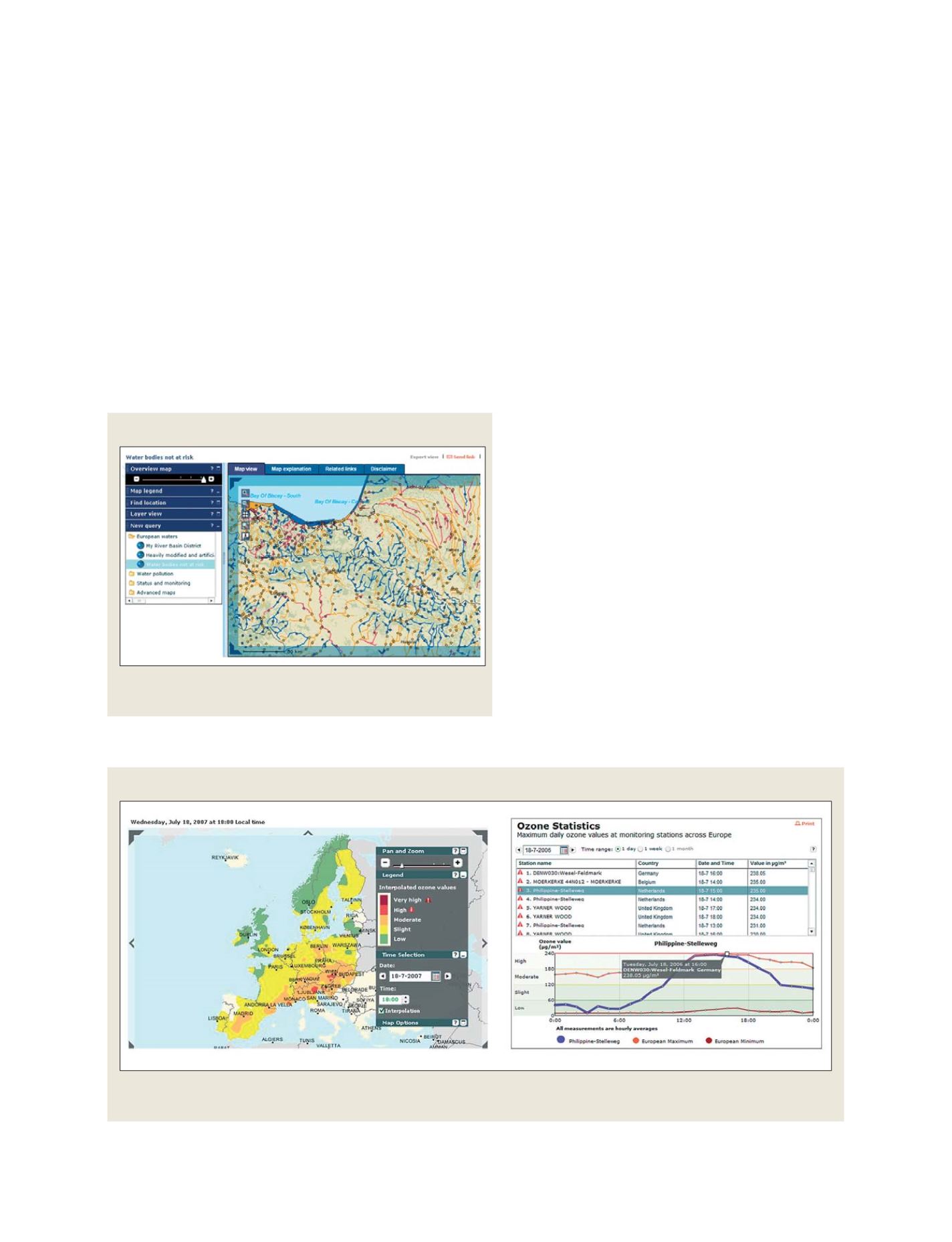
Ozone Web – near-real-time air quality information
Ground-level ozone conditions across Europe are
mapped in near-real time based on hourly data frommore
than 700 air quality measurement stations
(http://eea.europa.eu/maps/ozone). Ground-level ozone
presents one of the most prominent air pollution prob-
lems in Europe. Up to 30 per cent of Europe’s urban
population is exposed to ozone concentrations above the
threshold levels set by the EU. Ozone pollution is respon-
sible for as many as 20,000 deaths in Europe every year.
It can irritate airways, causing breathing difficulties and
damaging lungs after only a few hours of exposure.
Timeliness of data availability is thus key to increas-
ing awareness of ozone pollution. The Ozone Web site
is kept up to date with near-real-time ozone data from
over 43 data providers
9
. It provides an overview of the
situation on a European level, as well informing users
about more local air quality information sources such
as national and regional air quality websites.
Water Information System for Europe
In 2007, EEA established the Water Information System for Europe
(WISE:
http://water.europa.eu). This is an operational web-based
service where users can view interactive maps and related informa-
tion on water quality collected by member states as well as European
and international bodies. The website is an example on how combin-
ing different thematic maps and data sources can create added value
to environmental data. WISE addresses data integration by combin-
ing spatial data from different legal reporting instruments as well as
from different sectors.
In its current version, WISE makes use of water quality monitor-
ing data, river networks, catchments, digital elevation models,
administrative boundaries, land cover and land use, as well as statis-
tics. By sharing water-related data in this way, WISE delivers
WISE
WISE information showing water bodies at risk in Northern Spain and
Southern France
Source: WISE;
http://water.europa.eu,EEA, 2007
Ozone Web
Ground level ozone concentration over Europe on 18 July 2007 at 6:00 p.m. local time,
and ozone concentration over the whole day as measured at a station in The Netherlands
Source: Ozone Web
http://www.eea.europa.eu/maps/ozone,EEA, 2007
GEOSS C
OMPONENTS
– D
ISSEMINATION
/I
NFORMATION
S
YSTEMS