


 133 / 280

[
] 133
As a joint European project, Ozone Web reflects the international
character of air pollution. Air pollutants are emitted in one place but
may have an impact in another many hundreds of kilometres away.
The website demonstrates how an international institution can create
partnerships with member countries to provide near-real-time infor-
mation on the environment to serve and empower citizens.
Functionality of the web tool includes:
• European status (the situation in Europe) including live status
data, recent historic status, stations and their location in Europe
• Advanced mapping tool
• Interpolated maps
• Comparison and trends
• Supporting texts.
In the coming years, the project plans to expand data coverage to
other pollutants such as particulate matter (PM).
These online services are seen as the first steps toward a seamless
Internet-based pan-European information system. The system is
expected to be interoperable with standards set by the European
Directive on Infrastructure for Spatial Information in Europe
(INSPIRE),
10
as well as ISO and OGC.
Outlook – toward a shared environmental information system
The European capacity to access and manage the wide range of infor-
mation and services required for environmental management is still
very fragmented, suffering from great heterogeneity in terms of orga-
nization, system architecture, technical implementation, data
structure and data access policy. The challenge is to interconnect the
many information sources and to build an integrated and dynamic
information area for environmental management.
In dialogue with member states, the European Community has
recently agreed upon the concept of a SEIS for Europe. The scope of
SEIS is to establish an integrated and sustained environmental infor-
mation system to improve the sharing of data within Europe and
beyond. Such an information system should lead to improvement,
both in the quality of environmental data and information, and in
its management, use and dissemination. The benefits of such a shared
information system are compelling and have already been recognized
by regional and international organizations beyond the EU, such as
UNEP/MAP’s proposal to establish a shared environmental informa-
tion system for the Mediterranean region.
SEIS will be built incrementally upon the information and systems
that already exist in the EU member states and at the European level.
The concept of SEIS is based on similar principles as those which
are applied in the EU Directive for spatial information in Europe
(INSPIRE):
• Information should be managed as closely as possible to its source
• Information is provided once and shared with others for many
purposes
• Information should be accessible to enable clients to make
comparisons at the appropriate geographical scale (e.g. countries,
cities, catchment areas)
• Information should be made available to the public after due
consideration of the appropriate level of aggregation, given possi-
ble confidentiality constraints, and at national level in the national
language(s).
SEIS will be based on a distributed or decentralized network of public
information providers for sharing environmental data and informa-
tion. This concept reflects, on the one hand, Europe’s
commitment to open society and governance and, on
the other hand, the possibilities offered by today’s infor-
mation and communication technology.
Links to GEOSS – toward a global monitoring system
The mission of EEA is closely aligned with the GEOSS
vision “to realize a future wherein decisions and actions
for the benefit of humankind are informed by coordi-
nated, comprehensive and sustained Earth observations
and information.”
11
In this context, EEA sees strong connections between
specific EEA projects, the European initiative on a shared
environmental information system and the GEOSS process.
The two web applications discussed above are examples of
early achievements in support of the GEOSS SBAs:
• The EEA near-real-time ozone website contributes to
“understanding environmental factors affecting
human health and well-being”
• EEA water information systems for Europe contribute
to “improving water resource management through
better understanding of the water cycle.”
In the coming years Europe’s monitoring capacities and
infrastructure will be further strengthened by the Global
Monitoring for Environment and Security (GMES)
programme. This programme aims to integrate satellite
and ground-based monitoring data into operational
services to provide geo-spatial information for policy
and decision makers.
12
GMES is anticipated to be the
main EU contribution to GEOSS. Four services are
currently in scope, covering ‘atmosphere’, ‘emergency
response’, ‘land monitoring’ and ‘marine’ services, and
are expected to be available from 2008 onward.
The ongoing activities of EEA, its network EIONET
and other EU institutions on improving European envi-
ronmental data flows and GMES will support GEOSS
goals to achieve significant progress in the nine SBAs of
the ten-year implementation plan.
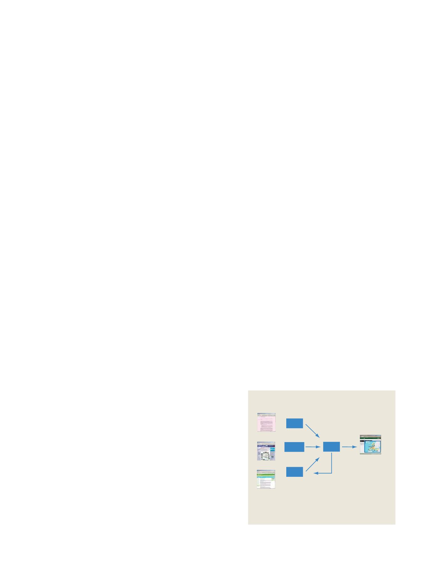
SEIS – Shared Environmental Information System for Europe
Potential 800,000
web pages
Potential 408,000
web pages
Potential 362,000
web pages
One European
website
France
Germany
UK
EEA
web services
for member states
The concept of SEIS is a distributed network of information
providers that enables the sharing of environmental data and
information. Members (here e.g. France, Germany, and UK)
deliver information and profit from tools and services of pan-
European web services
Source: EEA, 2007
GEOSS C
OMPONENTS
– D
ISSEMINATION
/I
NFORMATION
S
YSTEMS