


 232 / 280

[
] 232
These biological and non-biological components
collectively constitute the structure of an ecosystem.
Ecosystems can be mapped by spatially delineating the
extents of their structural components. An ecosystem’s
distribution on the landscape changes when one or
more of its structural elements change.
The GEOSS ecosystem classification and mapping
approach is based on this premise that ecosystems can
be geospatially represented by mapping and integrat-
ing their structural components. The ecosystems of
South America were recently mapped in this fashion
and represent a proof-of-concept for the approach.
3
For South America, continent-wide geospatial datasets
were developed for landforms, elevation class, lithol-
ogy and bioclimate, and these were combined to
produce a map of unique abiotic environments for the
continent at a relatively fine spatial resolution (450m).
These abiotic ecosystem footprints were then
combined with land cover, as a proxy for the vegeta-
tion (biota). Ecosystems were thus modelled as unique
physical environments and their associated land cover.
The ecosystems were subsequently labelled (‘cross-
walked’) with ecosystem names from an existing
classification. Six hundred and fifty-nine ecosystems,
each with multiple polygonal occurrences, were
mapped across the continent. Similar work is nearing
completion for the continental United States, and
mapping ecosystems under the GEOSS commission
has been initiated for China, Africa, Australia, and
Indonesia/Pacific.
The GEOSS global ecosystems mapping model
The GEOSS has a conceptual model for mapping the
planet’s terrestrial ecosystems, with freshwater and
marine conceptual models in development and testing.
The ecosystem mapping is essentially a top-down,
biophysical stratification of the planet into unique phys-
ical environments and their associated biota. Data
processing efforts are considerable, but are likely to be
enabled through a combination of GEOSS mandates and
opportunities for fruitful collaborations between stake-
holders.
Earth observation and global
ecosystem mapping and monitoring
The GEOSS global ecosystem mapping approach is
fundamentally an application of earth observation from
satellite imaging, combined with other physical envi-
ronment characterizations derived from field
observations. Several key input layers representing
ecosystem structure (landform, elevation class, soil
moisture etc.) are partly or wholly derived from digital
elevation models. Similarly, land cover is mapped from
image interpretation, and lithology data are often
imagery-supported as well. Climate regions are mapped
using spatially-interpolated field observations from
weather stations. Earth observation data are thus essen-
tial for both mapping global ecosystems, and monitoring
their condition.
recognition of this problem and the need for finer scale, standardized
ecosystem mapping, GEOSS commissioned a new classification and
map of the planet’s terrestrial, freshwater, and marine ecosystems. The
products from this effort will greatly enhance the ability to manage and
conserve global terrestrial, freshwater and marine ecosystems. This
effort supports, and in some cases underpins, several other GEOSS
tasks from the ecosystems and biodiversity societal benefit areas. The
map of global ecosystems resulting from this work will represent the
first attempt to classify and map global ecosystems in a standardized and
robust fashion at a scale appropriate for most ‘on-the-ground’ manage-
ment applications.
Ecosystem distributions
Ecosystems have been defined in many ways, all essentially as
dynamic assemblages of interacting native plant and/or animal
communities that 1) occur together on the landscape or in the water,
and 2) are tied together by similar ecological processes (e.g. fire,
hydrology), underlying environmental features (e.g. soils, geology)
or environmental gradients (e.g. elevation). Ecosystems have both
biological and non-biological components.
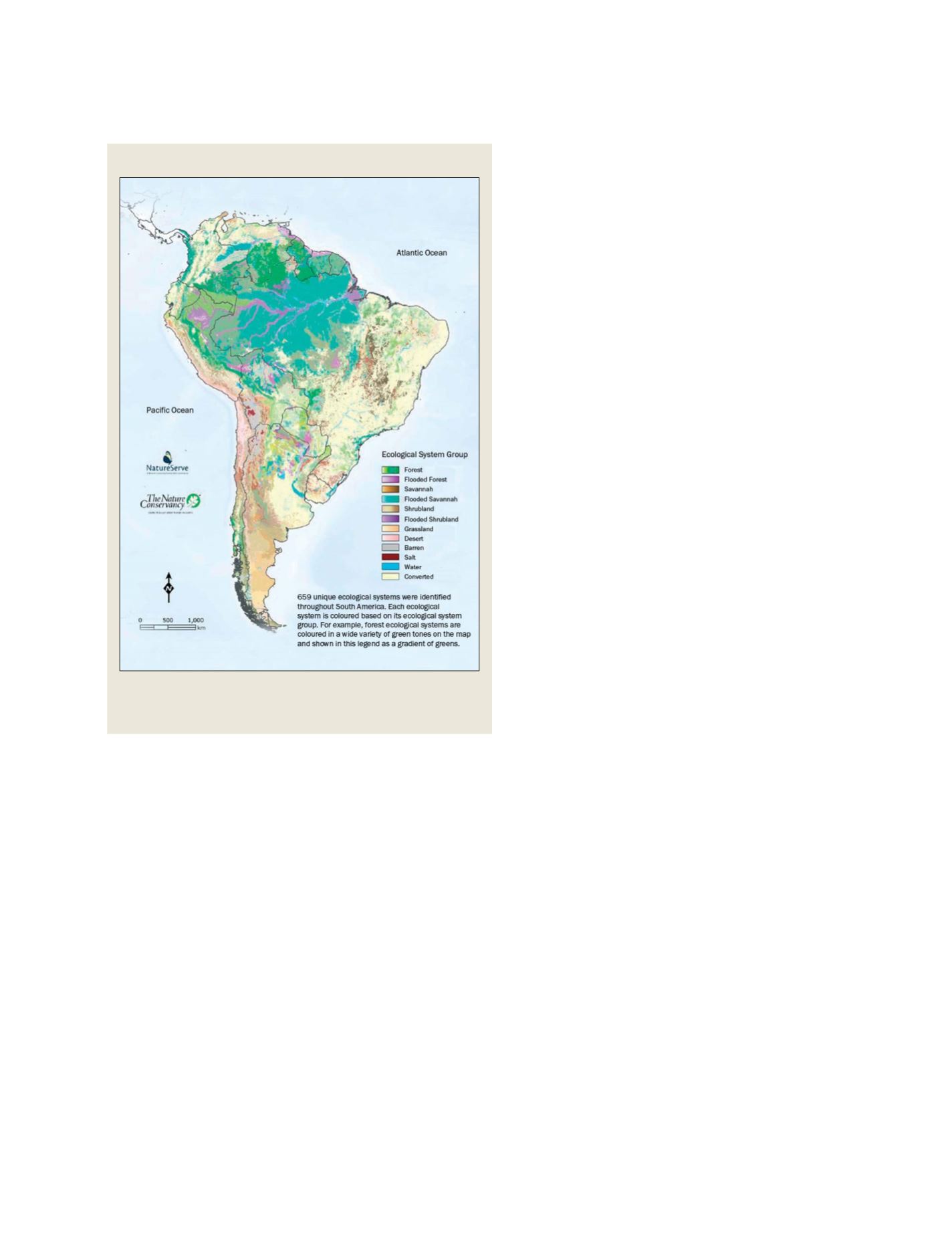
Ecological systems of South America
The ecosystems of South America, derived from a biophysical
stratification of the continent using landforms, elevation class,
bioclimate, lithology and land cover
Source: Sayre, R., J. Bow, C. Josse, L. Sotomayor, and J. Touval, Terrestrial Ecosystems of
South America: Washington, D.C., Association of American Geographers, 2007
(accepted for publication)
S
OCIETAL
B
ENEFIT
A
REAS
– E
COSYSTEMS