


 73 / 280

[
] 73
Today, nearly 60 per cent of that initial specification has
been completed, and an overall strategy and implemen-
tation plan for Coastal GOOS has been approved by the
GOOS member states.
Increasingly, these instruments record biological, chem-
ical and geological data and variability in addition to
physical variables such as temperature, salinity and surface
weather. A fully implemented GOOS will efficiently link
observations and models for mitigation of environmental
damage, improvement of predictions of drought and flood
in support of agriculture, fire-fighting, water resource
management and human health; management of marine
and coastal ecosystems and resources; protection of life and
property on coasts and at sea; and facilitation of scientific
research.
The primary international coordination for GOOS is
provided by the Intergovernmental Oceanographic
Commission (IOC) of UNESCOworking together with the
World Meteorological Organization (WMO), the United
Nations Environment Program (UNEP) and the
International Council for Science (ICSU). The design and
implementation of the open ocean component of GOOS is
overseen by panels of experts, member states and partici-
pating organizations cooperating through the joint
WMO-IOC Commission for Oceanography and Marine
Meteorology (JCOMM). The Partnership for Observation
of the Global Ocean (POGO) links much of the ocean
research community with GOOS, providing ocean obser-
vations and active participation by the world’s fleet of deep
sea research vessels. The coastal aspects of GOOS are imple-
mented through member states and participating
organizations operating independently or cooperating
through GOOS Regional Alliances.
How GOOS contributes to GEOSS
The current implementation of GOOS has components in
place which are routinely used for warnings and forecasts
of great benefit to society. Below are several examples, from
forecasting disasters to sea level measurements to coastal
coordination, all of which show the value of an integrated
global system.
Forecasting disasters
Major storms and destructive waves are a particular concern
to coastal communities. GOOS data gives communities
basic information that they need for forecasts of these
increasing dangers. Tsunamis are one important example,
and GOOS has contributed to the development of a tsunami
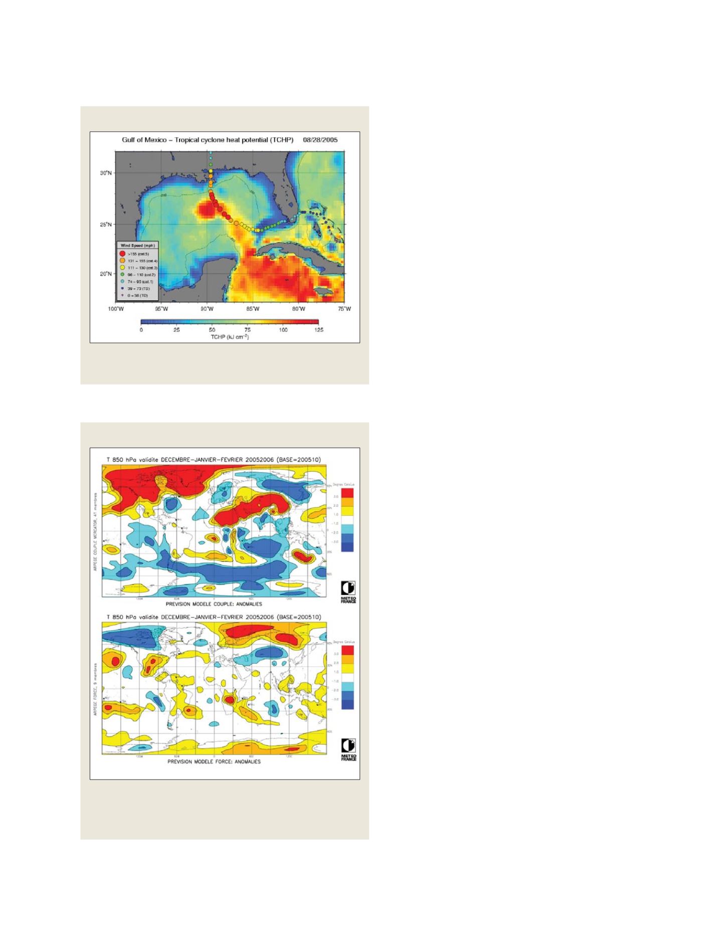
warning system. Another example is hurricanes: the image
below shows how oceanic hurricanes draw their energy
from the underlying warm ocean surface. Better forecasts
of ocean temperature from the satellites and buoys in the
GOOS observational system are providing better estimates
of storm generation and intensity. These in turn are allow-
ing communities to prepare for oncoming storms and to
mitigate damage. Investments in the systemprovide a good
return – for example, a recent study in the UK showed a
roughly twenty to one benefit/cost ratio for the information
provided from oceanographic satellites.
Tropical Cyclone Heat Potential associated with Hurricanes Katrina and
Rita; the hurricanes grow in intensity as they pass over warm water
Source: NOAA/AOML
Climate forecasts depend upon changing ocean conditions
Composite figure showing the winter forecast for 2005-2006 with a
coupled ocean atmosphere model initialized with (upper) and without
(lower) the Mercator ocean analyses; the cold anomaly over Europe is
missed without the ocean information
Source: Meteo France
Observations of ocean heat content critical to storm forecasts
GEOSS C
OMPONENTS
– O
BSERVING
S
YSTEMS