


 69 / 280

[
] 69
ballasting, ‘glides’ along programmed track lines to collect data with
much higher spatial resolution than conventional Argo floats, near
ocean boundaries or other special regions.
The international essence of the Argo programme
The creation of the Argo array has involved a degree of
international collaboration that is unprecedented in
oceanography. The goal of achieving global coverage
requires that national Argo programmes put their
regional priorities second to the global objective. Two-
thirds of the ocean is in the southern hemisphere while
most Argo floats are provided by northern hemisphere
nations. The international Argo Steering Team (AST)
coordinates the national efforts, working on the basis of
consensus among partners to encourage and ensure
nearly uniform coverage of the global oceans.
The AST is also responsible for uniform standards of
data quality, in terms of float hardware and data process-
ing, and uniform data formatting. The latter functions
are overseen by the AST’s Data Management Team. All
Argo national programmes adhere strictly to Argo’s policy
of free and unfettered exchange of data. Argo is carried
out for the benefit of all nations, not for individual partic-
ipants. Similarly, all nations can contribute to Argo, if
not by providing floats and data management services,
then by facilitating float deployments and helping to
analyse and gain value from Argo data. Through collab-
oration, the national origins of floats become irrelevant
and the Argo array becomes an asset for all mankind.
The benefits of the collaborative international approach
are demonstrated in the image above, which shows, maps
of recent ocean conditions in several regions. The data to
make these plots were gathered during the last ten days
Distribution of ocean properties
Plots of the distribution of some ocean properties using data acquired
during the last ten days of July 2007. Clockwise from top left the plots
show sea surface temperature surrounding southern Africa, salinity at a
depth of 200 metres, temperature at 100 metres in the North Pacific
and sea surface temperature again, this time in the North Atlantic
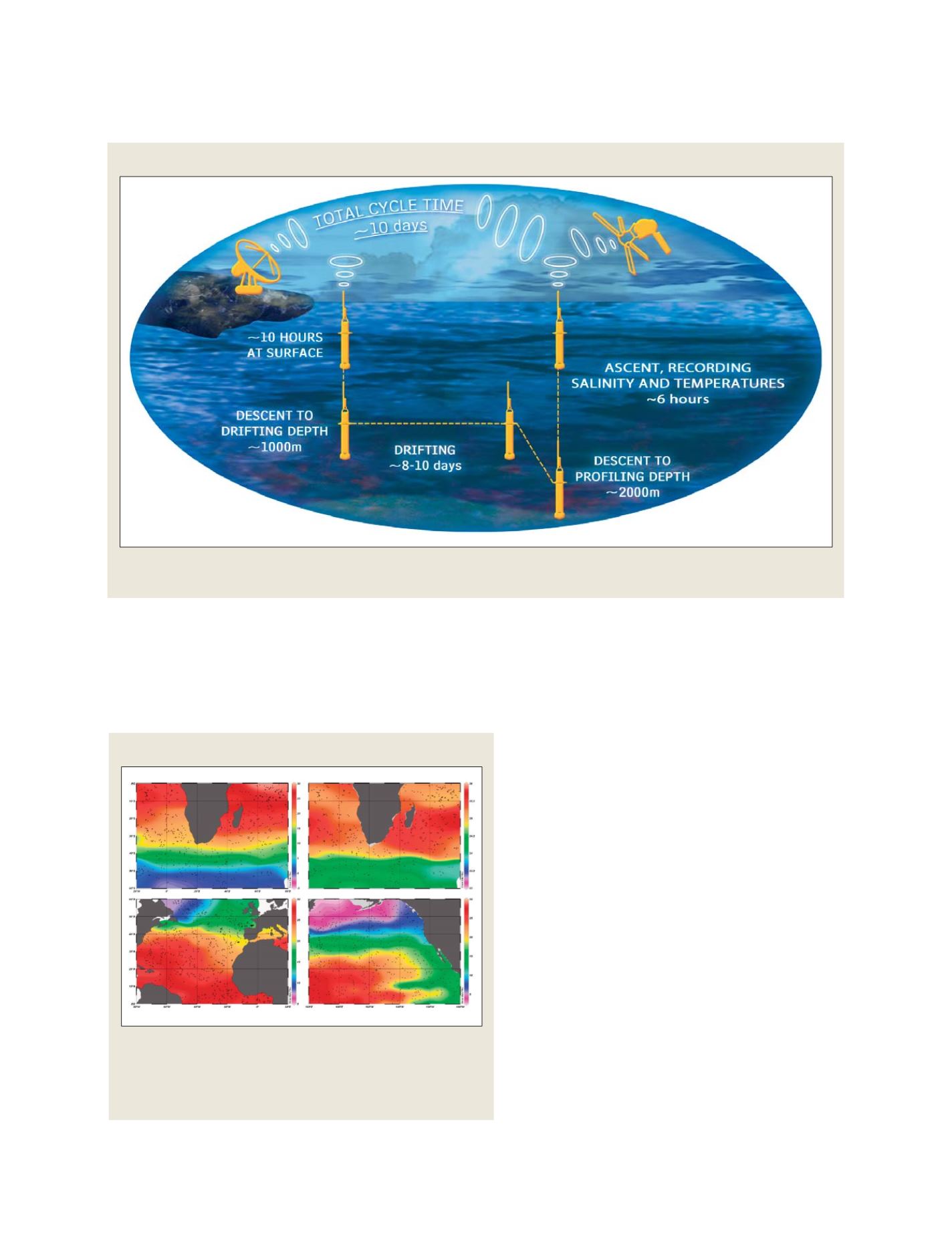
A typical duty cycle for an Argo float
An Argo float is launched on the sea surface. It sinks to around 1,000 metres depth and then drifts with ocean currents for ten days before diving to
around 2,000 metres. It then ascends to the sea surface, measuring temperature and salinity on the way up, before repeating the process
Source: Argo Information Centre – Mathieu Belbéoch
Source: Howard Freeland (using Ocean DataView)
GEOSS C
OMPONENTS
– O
BSERVING
S
YSTEMS