


 64 / 280

[
] 64
In order to facilitate implementation of network
improvements specifically in Africa, a meeting was orga-
nized by GCOS in Addis Ababa, Ethiopia in April 2006,
with the meteorological community, the communities
of users of climate information, and potential donors. It
lead to an agreement to launch a ten-year programme
called ‘Climate for Development in Africa’ (ClimDev
Africa), that would focus on improving climate infor-
mation in support of achieving the Millennium
Development Goals.
It received the initial support of the African Union
Commission, the UN Economic Commission for Africa
and the UK’s Department for International Development,
and a number of countries and agencies have declared
their intention to join. Following these endorsements,
ClimDev Africa is intended to be a fully integrated, user-
driven programme that addresses not only needs for
improved climate observations as expressed in the
GCOS regional action plans, but also needs for climate
services, climate risk management, and associated policy
development and implementation.
GCOS as a component of GEOSS
The GCOS community has been closely involved in the
development of GEOSS since the beginning, and actively
participated in the first Earth Observation Summit in
Washington DC in July 2003. GEOSS basically extends
the GCOS concept of a ‘system of systems’ to a wide
range of societal benefit areas (SBA), which require
timely, high quality long-term global information as a
basis for sound decision making, and in order to better
serve societal needs. The main thrusts of the climate
SBA, ‘understanding, assessing, predicting, mitigating
and adapting to climate variability and change”, are in
great part reflected in the thrusts of GCOS, and it is
natural to consider GCOS as the climate component of
GEOSS. However, as mentioned in GEOSS 10-year
Implementation Plan: ‘the climate has impacts in each
(IPCC), and a range of international programmes or projects that
make use of climate information for societal or economic applica-
tions.
GCOS has more specifically conducted, with the funding of donor
countries, a programme of renovation or establishment of new surface
and upper air observing stations, complemented by technical support
projects in developing regions of the world. The two main atmospheric
GCOS networks are the GCOS Surface Network (GSN) and the GCOS
Upper Air Network (GUAN). Other networks of importance for
climate monitoring, dedicated for example to the measurement of
atmospheric constituents, surface radiative measurements, and hydrol-
ogy related variables have been formally associated with GCOS, and
benefited from GCOS support and expertise. The programme has also
greatly supported the development of the research based ocean observ-
ing system, including the Argo profiling float network (comprising
approximately 3000 floating stations worldwide), with the goal of a
transition into a fully operational network.
With respect to space observation, a close consultation has been
developed with space agencies, under the Committee on Earth
Observation Satellites (CEOS) and the Coordination Group for
Meteorological Satellites (CGMS), and in coordination with the
WMO Space Programme, in order to encourage the development
of the space component of GCOS, along the lines of the IP. A
specific document prepared by GCOS entitled Systematic
Observation Requirements for Satellite-Based Products for Climate
has been presented to the UNFCCC and published in 2006,
serving as a basis for the preparation of a coordinated plan by space
agencies.
Action on national and regional levels is central to the improve-
ment of global observations for climate. The GCOS Regional
Workshop Programme, supported by the Global Environmental
Facility and United Nations Development Programme has since
2000, through the development of regional action plans and follow-
up activities in ten regions worldwide, identified national and
regional needs and deficiencies for climate data, including needs for
assessing climate impacts, conducting vulnerability analyses, and
undertaking adaptation studies. It also has a great impact on capac-
ity building in developing countries.
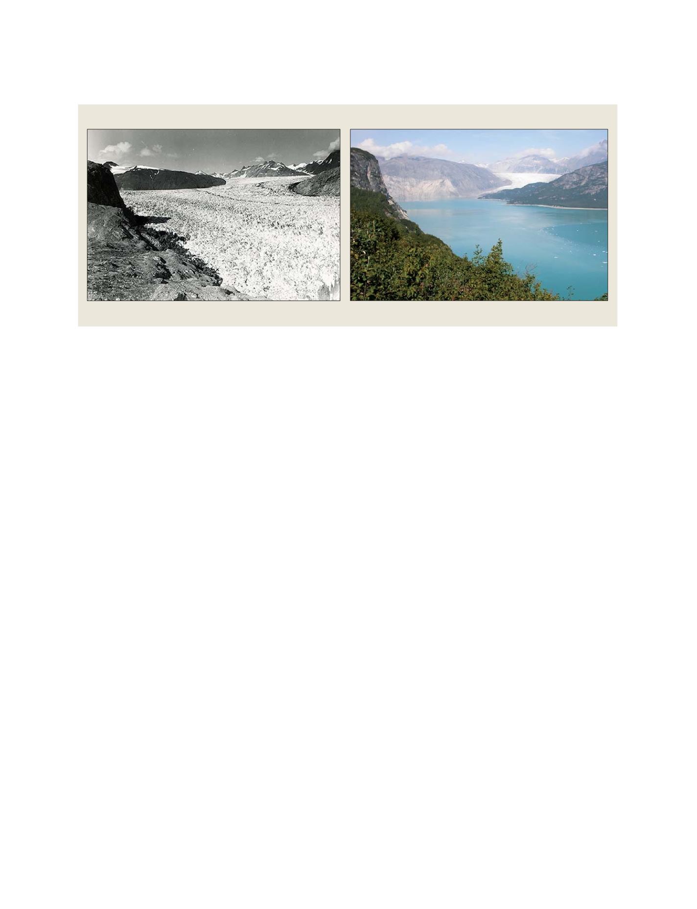
Muir Glacier (Alaska) in August 1941 and 2004
The global monitoring of glaciers, under the World Glacier Monitoring Service, is one of the numerous types of observations undertaken through GCOS
Source: US National Snow and Ice Data Center, W. O. Field, B. F. Molnia
GEOSS C
OMPONENTS
– O
BSERVING
S
YSTEMS