


 55 / 218

[
] 55
United States during the 2004-2005 hurricane season. Wheat
stem rust (Ug99) was identified in 1999 in Uganda. The
Consultative Group for International Agricultural Research esti-
mated that the potential spread of wheat stem rust throughout
Africa, the Middle East and South Asia would destroy 19 per
cent of the total world wheat production. Wind is one of the
primary transport mechanisms for this disease. Collaborations
between agricultural scientists and meteorologists are expected
to result in significant improvements in the wheat stem risk
assessment map. This, in turn, would allow the development
of a more effective early warning system for the disease.
Drought mitigation through the application of climate-
based decision support tools
The National Drought Mitigation Center (NDMC) was
founded in 1995 to help people and institutions in the US and
throughout the world implement risk management measures
to reduce vulnerability to drought. The NDMC is involved in
numerous projects with the US Department of Agriculture
(USDA) and the National Oceanic and Atmospheric
Administration (NOAA) to develop appropriate decision
support tools to help agricultural producers, natural resource
managers and policy makers. Such decision support tools aim
to facilitate more timely and appropriate risk-based manage-
ment decisions before and during the growing season. This
relates especially to minimizing losses associated with severe
drought conditions.
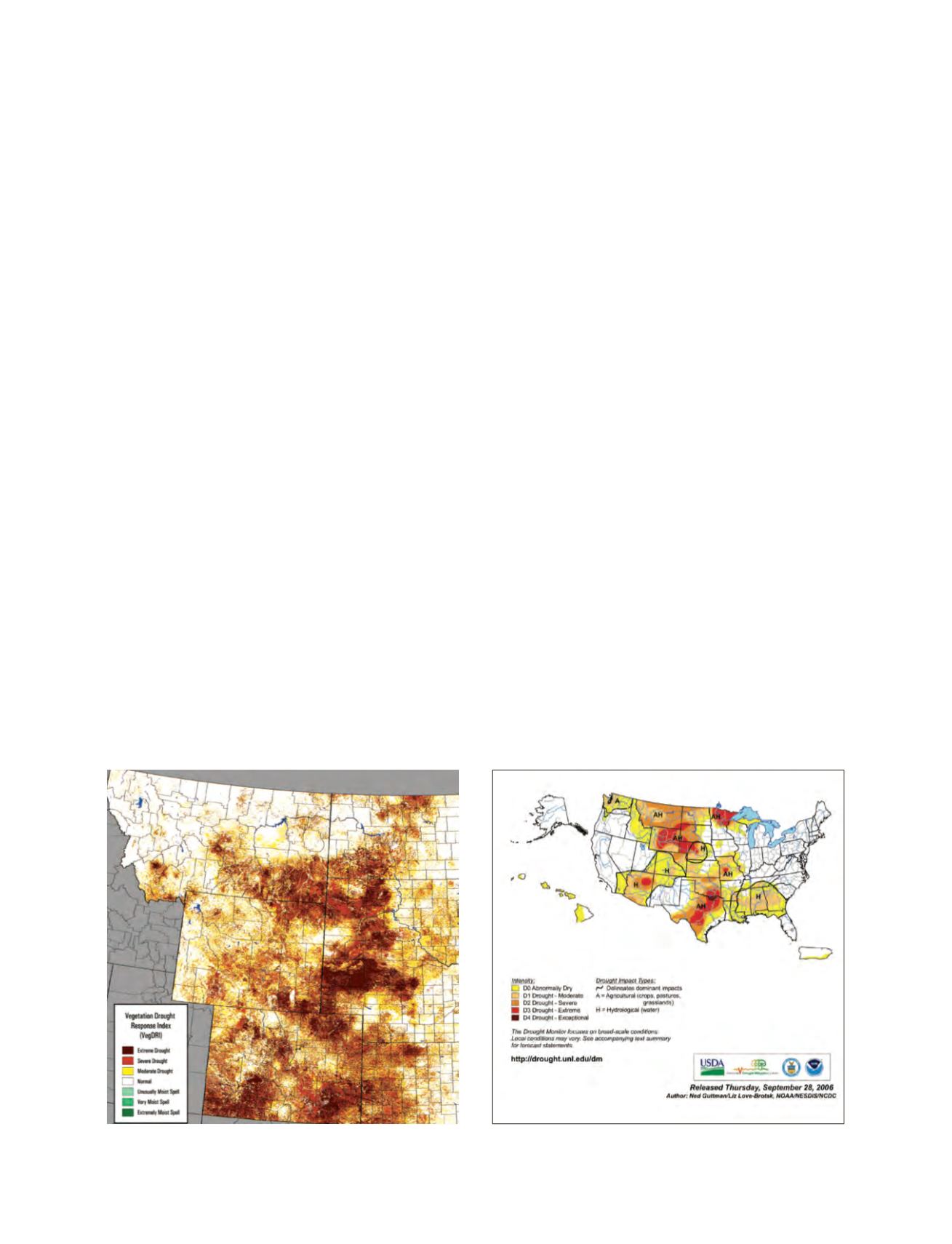
The NDMC also focuses on improving monitoring, mitiga-
tion and preparedness for drought events. An example of one
of the recent tools developed by the NDMC, in collaboration
with the US Geological Survey, is the Vegetation Drought
Response Index (VegDRI). The VegDRI tool produces a map
at a 1-km spatial resolution that categorizes drought-induced
vegetation stress. It provides a detailed view of drought stress
conditions over large geographic areas, but has adequate spatial
detail to characterize localized drought patterns as well. This
map is useful in assessing the potential impact of drought
conditions on crop and range production.
Collaboration between NMHS and other agencies
A memorandum of understanding between the NMHS and the
USDA created the Joint Agricultural Weather Facility (JAWF).
This serves as an excellent example of a cooperative effort
between the NMHS (Climate Prediction Center, NOAA) and
another federal agency. JAWF is located within the World
Agricultural Outlook Board (WAOB) under the USDA’s Chief
Meteorologist. WAOB has the operational responsibility for
monitoring and analyzing the impact of global weather on
agriculture. The current contribution of information from
USDA and NOAA to JAWF is approximately two parts to one,
respectively.
As a result of more than 20 years of collaborative effort,
JAWF is providing a suite of short-term tactical agricultural
weather products. These include routine and special agricul-
tural assessments, weekly weather and crop bulletins, and
enhanced regional weather data. There are also long-term
strategic agricultural weather products, including USDA crop
and livestock supply and demand estimates, and crop plant-
ing recommendations.
An outgrowth of this collaboration is the cooperation
between these two federal agencies and the National Drought
Mitigation Center. Together, they have developed the US
Drought Monitor (USDM). This comprises a weekly Web-
based product that depicts the spatial extent and severity of
drought across the US. The USDM is based on multiple indices
and indicators, and presents a comprehensive snapshot of
drought conditions. This product has not only improved aware-
ness of the severity of drought conditions, but is also being
used widely for policy decisions by USDA on eligibility for
drought-related disaster assistance.
One of the key elements in effectively applying weather,
climate, and water information to agriculture is an efficient
relationship between users and providers. The USDM
actively solicits the input of experts across the country in
the preparation of its weekly map. This action helps to
‘ground truth’ the accuracy of the characterization of drought
conditions.
VegDRI map for 25 July 2002
US drought monitor, 26 September 2006