


 161 / 196

[
] 159
Flying at 150-200 knots, the aircraft is able to cover over
4,000 miles during flight operations. The
Ikhana
was first
put into service for NASA in January 2007, and flew its
first science missions in support of wildfire observations
in August 2007. The platform is intended for aeronautics
and earth science research within the US Government.
The
Ikhana
is ideally suited to support long-
endurance/duration missions, such as those found in a
major disaster scenario, where critical observation time
over the event is required. Special coordination with the
Federal Aviation Administration (FAA) was required to
safely operate the
Ikhana
UAV in the National Airspace
(NAS).
AMS-Wildfire sensor
The AMS-Wildfire airborne sensor was developed at
NASA to serve the fire research and applications
community. The sensor is a twelve-spectral-channel
instrument (visible through thermal-infrared), capable
of high-altitude, autonomous operations on a multitude
of airborne platforms. Two critical channels in the
thermal-infrared allow discrete, high-temperature
discrimination of fire properties, and were used to derive
the critical fire front locations for the fires in southern
California. An automated fire-detection threshold
temperature processing model was also developed. The
temperature threshold model produces an additional file
set from the sensor that displays the active hotspots, in
addition to the thermal imagery. All the data processing
was done autonomously, on-board the UAV. This
processing included both geo- and terrain-rectification,
and development of GEOTIFF files from various spec-
tral band combinations, determined by the fire
personnel on the ground.
tools and capabilities for gathering, distributing and analysing real-
time wildfire information.
NASA capabilities and science teams respond
NASA responded to the request for federal aid by making available
both satellite and airborne sensor data to assist in the fire obser-
vations and management operations conducted by the Incident
Command Centers (ICC) and the county-level Emergency
Operations Centers (EOC). Concurrent with the southern
California fires, NASA and the USFS were collaborating on a project
focused on improving various wildfire observation and manage-
ment capabilities, using NASA-derived technologies. Those
capabilities and technologies included using unmanned airborne
vehicles (UAVs) as observation platforms, improving the thermal
sensing capabilities of instruments on those platforms, providing
real-time derived data and products from those sensors, and
demonstrating an easy-to-use data ‘collaborative environment’ and
visualization tool to effect improved fire management by teams on
the ground.
When the southern California wildfires struck, the two federal
agencies (NASA and USFS) responded with all their available
resources, including the provision of various satellite imagery and
the use of the NASA
Ikhana
UAV platform with the Autonomous
Modular Scanner – Wildfire instrument on-board. All the derived
data, imagery and products were delivered via a common visualiza-
tion Collaborative Decision Environment (CDE), based on
GoogleEarth
®
visualization software. The fire ICCs and the EOCs
received and used all of the data through operations of the CDE
during the NASA airborne support missions.
NASA UAV
The NASA
Ikhana
UAV is a modified General Atomics Predator-B
aircraft, designed specifically for supporting NASA science missions.
The platform is capable of 24-hour duration, and 50,000 feet altitude.
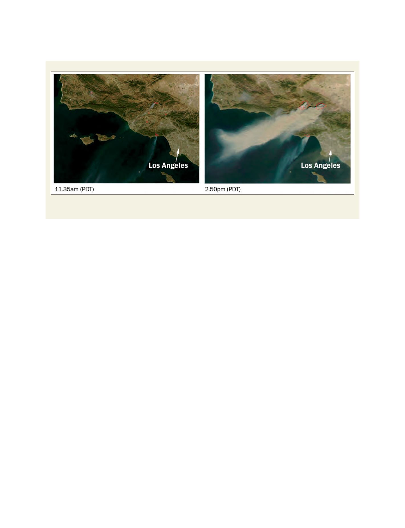
MODIS satellite images of southern California wildfires
Two NASA MODIS satellite images from 21 October 2007 show how quickly the fires spread. The right image was taken just three hours
and 15 minutes after the left image
Source: NASA MODIS