


 165 / 196

[
] 163
In 2004 France launched the first dedicated satellite,
DEMETER, to study the electromagnetic effects related
to earthquakes in the ionosphere. For the last four years
in orbit, multiple examples of electromagnetic emissions
associated with major seismicity have been collected.
5
After the Sumatra mega-quake in 2004, several coun-
tries with high seismic risk such as Russia, China,
Mexico, USA, Japan, Taiwan and Ukraine started to plan
new space observations in support of earthquake hazard
risk reduction. This is significant news to support a solid
earth-atmospheric relationship.
Earlier studies have shown that there were some EM
effects in the atmosphere/ionosphere caused bymajor earth-
quakes, and several theories have been formulated to
explain their causes.
6
Some of the major events are accom-
panied by intensified vertical transport of charged aerosols
in the lower atmosphere. These processes lead to genera-
tion of external electric current in the perturbed region of
the atmosphere and in the ionosphere-atmosphere electric
circuit. The Lithosphere-Atmosphere-Ionosphere Coupling
tion along faults, and mapping ground deformation after earth-
quakes. Currently their impact on early warning signals remains to
be further studied.
The Moderate Resolution Imaging Spectroradiometer (MODIS),
the key instrument of the NASA Earth Observing System (EOS), and
the Atmospheric Infrared Sounder (AIRS), a high-resolution infrared
sounder, were launched aboard the Aqua satellite in 2002. The suite
of Aqua instruments, together with those on the Terra satellite
(launched on 18 December 1999), enable global monitoring of the
atmosphere and lithosphere and are developing long-term data sets
for climate research. Additionally, the multi-channel (2378) AIRS on
board Aqua, constitute an innovative atmospheric sounding group
of visible, infrared and microwave sensors that measure temperature
to better understand the vertical atmospheric structure. We have
been exploring the potential benefits of combined use of the MODIS,
AIRS and NOAA/AVHRR historical database under the Sensor Web
framework, and obtaining an unprecedented volume of information
on the Earth’s atmosphere and land surface properties. This config-
uration is a key factor in understanding the nature of
earthquake-related atmospheric signals.
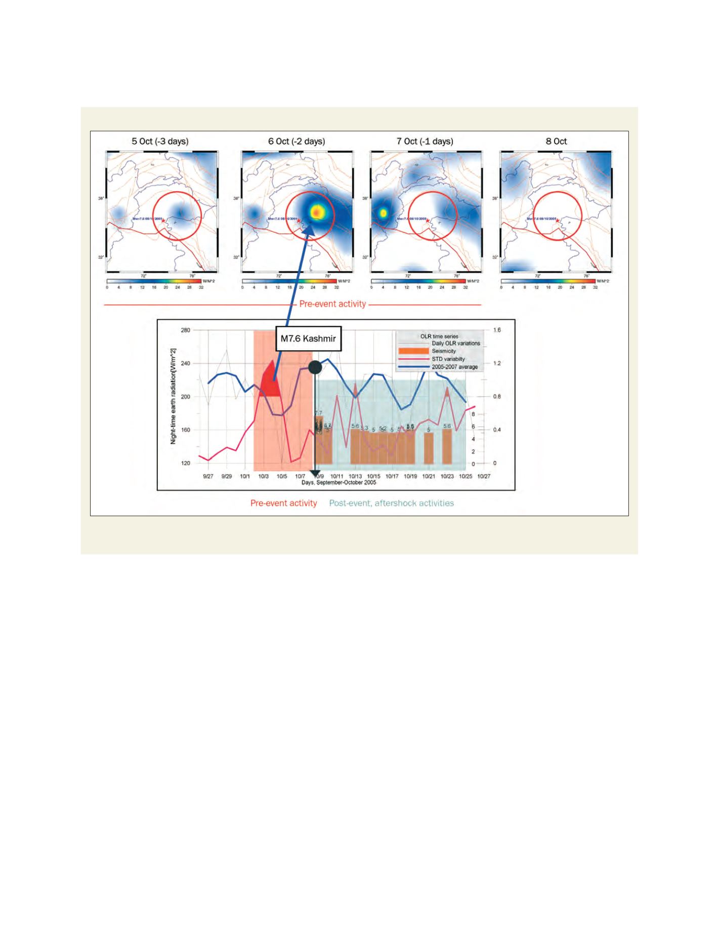
Thermal atmospheric signals observed during the M7.6 Kashmir earthquake of 8 October, 2005
Top: Maps of daily night-time anomalous OLR (NOAA/AVHRR) over Pakistan/Kashmir region for 5-8 October. The M7.6 Kashmir Earthquake occurred on
8 October 2005. Bottom: Time-series of daily night-time OLR variations for 25 September-25 October 2008 over the epicentral area
Source: Ouzounov D. and S.Habib, Application of remote sensing technologies for disaster risk management: Mutisensor approach of analyzing atmospheric process
related to M7.6 Kashmir earthquake of October 8, 2005 in
Remote Sensing Applications for Societal Benefits
Editor: S.Habib, Springer-Verlag, 2008 (in preparation)