


 144 / 280

[
] 144
GEO vision of a future wherein decisions and actions for the benefit
of humankind are informed via coordinated, comprehensive and
sustained Earth observations and information.
The centrepiece of the NADM is a group of drought experts and
database specialists from across the continent working together in an
ongoing operational capacity, to carefully compile and analyse
disparate climate observations at multiple scales. This service, which
is produced in English, French and Spanish translations, serves the
needs of user communities within sectors as diverse as agriculture
and forestry, water resource management, energy markets, and health.
Because no single definition of drought is appropriate in all situ-
ations, drought experts developing the NADM product depend on
several key indicators and indices when performing each analysis.
Daily temperature and precipitation data for stations across the US,
Canada, and Mexico are provided by each country on an operational
basis. Monthly temperature and precipitation values are computed
from these daily data and used to generate several drought indices,
including the Standardized Precipitation Index, percent of normal
precipitation, and the Palmer Drought Severity Index. These in situ
indices are combined with satellite-based indices and modelled soil
moisture data to provide a comprehensive and consistent assessment
of moisture conditions across the North American continent, includ-
ing drought transitions across the international borders. These
objective indicators are further combined with input from experts
at the local and regional level from across the continent to provide
NADM drought experts with information on impacts and conditions
which are not available from observations alone.
GEOSS principles and functional components formed the basis
for development of the NADM program. Close coordination among
government leaders and scientists in each country provided the
means for identifying critical gaps in existing programmes and in
establishing methods for addressing deficiencies. Processes were
established to facilitate the open exchange of data and information
across borders, which proved a key element of building
the capacity to monitor drought conditions on an
ongoing basis across the continent. While this effort was
successful in improving the delivery of drought infor-
mation to end users, it also established a precedent for
how nations, when working together within a GEOSS
framework, can turn disparate observing systems and
limited individual resources into an integrated program
to enhance decision making.
The National Integrated Drought Information
System
Within the US, government leaders have recognized the
need to improve the nation’s capacity to manage
drought-related risks, to provide appropriate informa-
tion tools to those affected by drought, and to improve
the nation’s readiness to mitigate the consequences of
drought. To meet these needs, a National Integrated
Drought Information System (NIDIS) is being estab-
lished.
9
Through NIDIS, a drought early warning system will
be created with the capabilities to provide accurate,
timely and integrated information on drought condi-
tions, at the relevant spatial scale, to facilitate proactive
decisions aimed at minimizing the economic, social and
ecosystem losses associated with drought. The US inter-
governmental leadership and partnerships will be key
to the implementation of an integrated national drought
monitoring and forecasting system, and NIDIS will
support research that focuses on impact mitigation and
improved predictive capabilities.
NIDIS will tie operational and research facets of the
drought issue into an interactive delivery system for
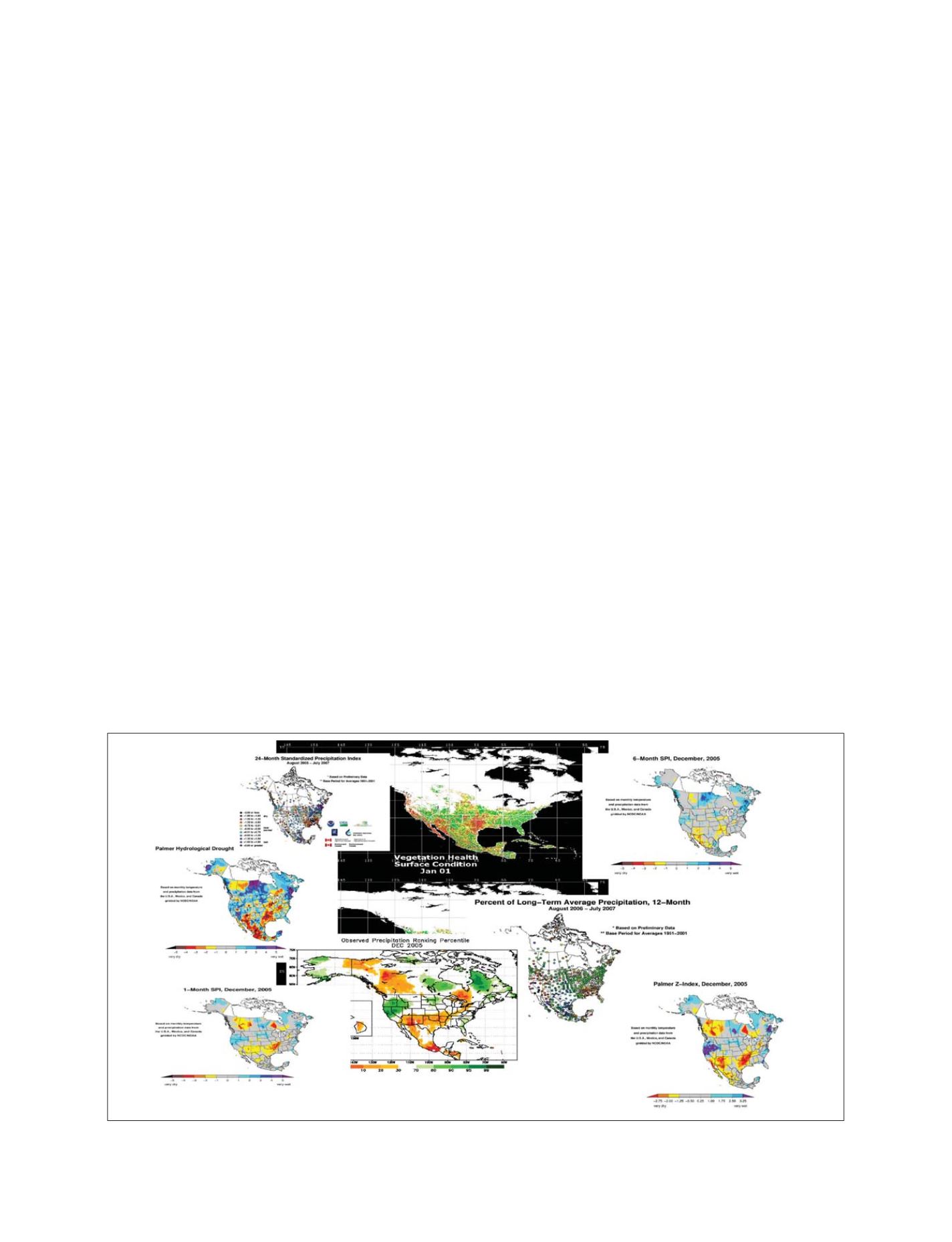
Drought experts rely on numerous objective indicators to determine drought severity levels across the continent
Source: NOAA; SMN; AAFC
GEOSS C
OMPONENTS
– P
REDICTION
S
YSTEMS