


 143 / 280

[
] 143
ture and evaporation also provide key indicators of
drought conditions. Other critical sources of informa-
tion include such measures as reservoir level,
streamflow, snowpack, and groundwater conditions.
When data from numerous and diverse observing
systems, many of which are unique to individual coun-
tries, are openly shared among nations, it becomes
possible to fill gaps in knowledge and clearly define the
state of drought within and across international borders.
In addition, it is essential that there be avenues for
communication and collaboration between drought and
technical experts within and among nations.
Experts familiar with the unique physical aspects of
drought within their country and in similar environ-
ments of other countries, through collaboration with
others in the scientific community, can develop an accu-
rate and cohesive picture of drought within and across
national borders. Furthermore, international partnering
and collaborative research efforts lead to more rapid
advances in drought monitoring science than would
otherwise be possible.
The North American Drought Monitor
The US, Canada, and Mexico,
7
recognizing the need of
decision makers for better drought monitoring infor-
mation, formed a trilateral partnership to enhance
drought monitoring on the North American continent.
8
These three countries established the North American
Drought Monitor (NADM) programme to provide infor-
mation on drought conditions across the continent on
an ongoing basis, and in so doing, helped achieve the
Africa causes economic losses of tens of millions of dollars and can
reverse years of national development gains.
6
Defining and monitoring drought
Drought, sometimes referred to as the ‘creeping disaster’, has a unique
character that defies a universal definition. The spatial extent of
drought is often greater than other natural hazards and its impacts
are often hard to quantify. While all droughts originate from a defi-
ciency in precipitation, a drought’s onset may be rapid but most often
it develops slowly, making it difficult to determine a beginning and
end. Drought may last from months to years, and its severity and
spatial extent may vary with time, moving back and forth in amoeba-
like fashion through various stages. The way drought responds to
anomalies of temperature, precipitation, wind speed, and solar radi-
ation differs depending on time of year, character of the local
environment, and type of climate.
Because of drought’s unique nature, varying impacts, and indis-
tinct temporal and spatial boundaries, no single set of observations
or single objective measure is sufficient for defining its severity or
onset. Only through a convergence of evidence is it possible to define
the boundaries of drought and produce a depiction of drought sever-
ity that can be used by a diverse group of decision makers.
Great quantities of environmental observations from a myriad of
land and space-based observing systems are essential to defining the
severity and spatial extent of drought. These include, but are not
limited to, in situ measurements of temperature and precipitation,
soil moisture, humidity, wind speed, and cloud cover. These surface
observations are augmented by satellite measurements, which help
fill gaps in coverage, while also providing measures of other indica-
tors of drought, such as vegetation health. Computer models that
estimate terrestrial and atmospheric conditions such as soil mois-
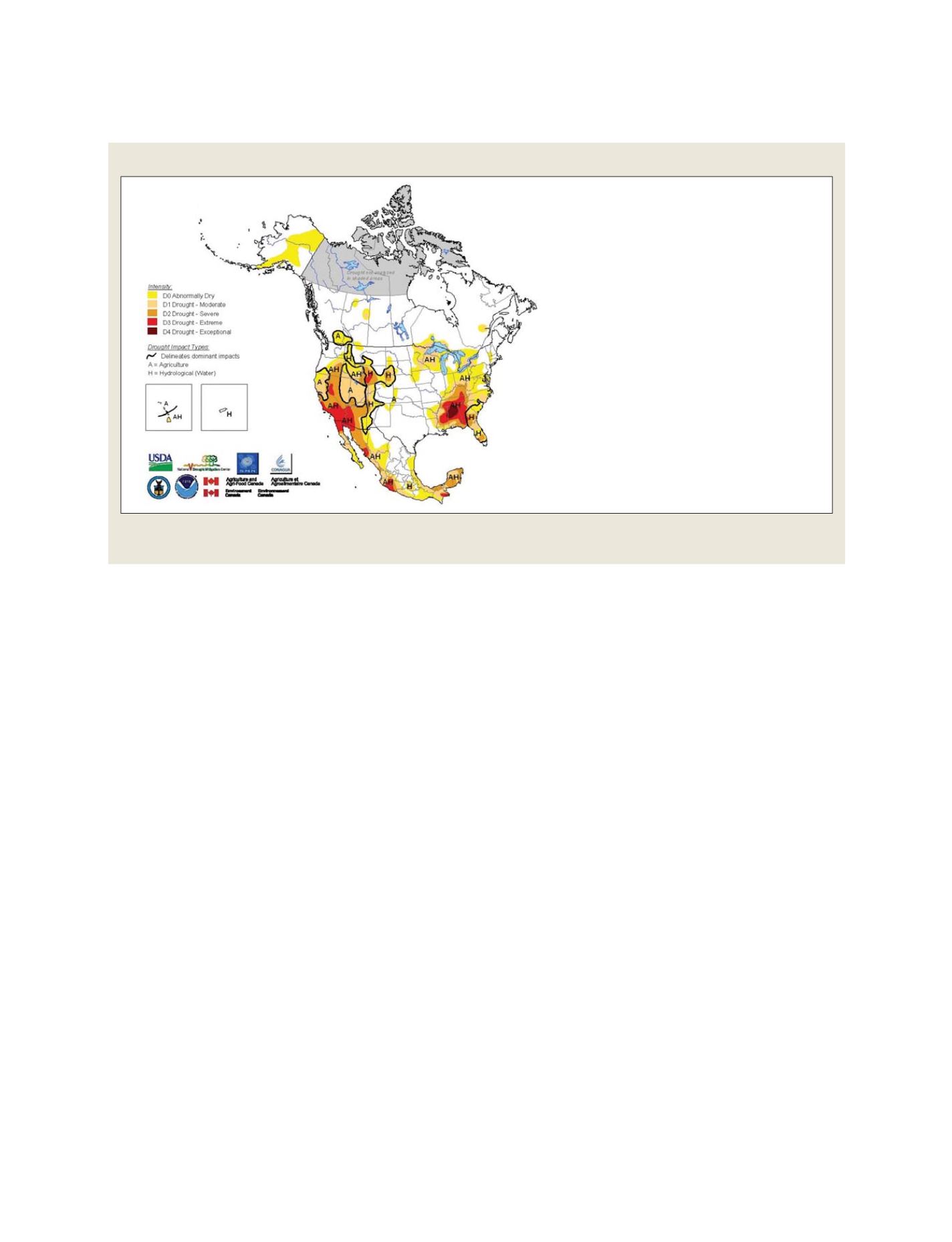
Example of the North American Drought Monitor map for 1 June 2007. The NADM product is produced on a monthly basis and has been available
since 2003 at www.ncdc.noaa.gov/oa/climate/monitoring/drought/nadm/index.html
North American Drought Monitor
Regions outside of the agricultural landscape of Canada
may not be as accurate as other regions due to limited
information.
The Drought Monitor focuses on broad-scale conditions.
Local conditions may vary. See accompanying text for
general summary.
http://www.ncdc.noaa.gov/nadm.htmlAnalysts:
Canada
Dwayne Chobanik
Mexico
Valentina Davydova
Elvia Delgado Diaz
Adelina Albanil
Reynaldo Pascual
U.S.A.
Brad Rippley
David Miskus*
(* Responsible for collecting analysts input & assembling
the NADM map)
Source: NOAA; SMN; AAFC
GEOSS C
OMPONENTS
– P
REDICTION
S
YSTEMS