


 167 / 280

FDRS tools for early warning are highly adaptable and have
demonstrated their application to a wide range of users, from inde-
pendent remote field stations (for making local fire suppression and
preparedness decisions) to global and regional fire information
centres (for large-scale decision making, such as resource sharing
across jurisdictions). There are many examples of current opera-
tional systems using GIS technology and computer modelling of
landscape-level fire danger
11
that process and transfer early warning
information very quickly via the World Wide Web.
While the scientific knowledge and technical capability to develop
large-scale operational FDRS for early warning exists, a global system
has yet to be established. The GOFC-GOLD Fire Implementation
Team is leading development of an operational global early warning
system for wildland fire through a collaborative international effort
by numerous partner agencies.
12
The goal of the early warning
project is to establish a scientifically supported, systematic proce-
dure for assessing and predicting international fire danger that can
be applied from local to global scales. By integrating existing ground-
based and earth observation data networks, the early warning system
will meet three primary objectives:
• Support existing national fire management programmes by
providing longer-term predictions of fire danger based on
advanced numerical weather models
• Provide early warning capability for countries
where financial and institutional capacity to
develop national systems do not exist
• Provide a common international metric for imple-
menting international resource-sharing agreements
during times of fire disaster.
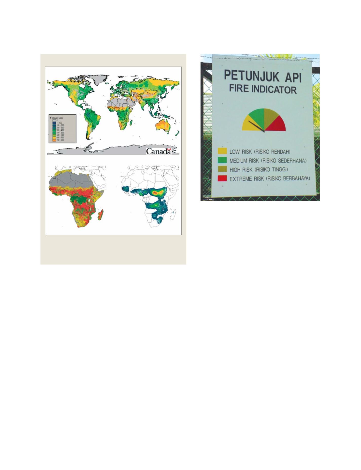
A pilot study, or prototype of the global early warning
system is being developed for sub-Saharan Africa.
13
The
prototype includes products to support fire management
decision-making at national (Ghana), regional (western
Africa), and pan-Africa levels. It includes the integra-
tion of data from a global network of fire weather data
with satellite hot spot data over Africa to display spatial
fire threat based on Drought Code
14
and hotspot density.
As an early warning product, it can be used to imple-
ment a range of fire management activities such as
prioritising values at risk, mobilizing resources to the
most threatened areas, and enhanced prevention and
detection in the critical regions.
Fire management programmes can limit or prevent
the damaging effects of uncontrolled wildland fire by
implementing fire prevention, detection, and suppres-
sion action plans. Operational decision-making is
based on the knowledge of current fire activity and
early warning of future burning conditions. GOFC-
GOLD supports the provision of this information
through global monitoring of active wildfires in near-
real time using polar orbiting and geostationary
systems, and by leading development of a global early
warning system for wildland fire using new fire
weather forecasting models and remotely sensed fire
and vegetation data.
[
] 167
A Global Early Warning System prototype for wildland fire
Examples of potential early warning products, including a) global fire danger
using the Drought Code (DC) component of the Canadian Forest Fire Weather
Index System (Van Wagner 1987); b) DC overlaid by hotspot data (red), and c)
spatial fire threat as assessed by DC and hotspot density
Source: Canadian Forest Service, Natural Resources Canada
B
C
A
Fire danger sign (Sabah, Malaysia)
Photo: Canadian Forest Service, Natural Resources Canada
S
OCIETAL
B
ENEFIT
A
REAS
– D
ISASTERS