


 239 / 280

[
] 239
been described and studied. It is also necessary for them to
develop a working, mappable classification system that
covers all vegetation, ecosystem and land cover classes.
An example of a rapid assessment is a recent scien-
tific investigation to map a globally significant
occurrence of a freshwater/groundwater inland lowland
swamp forest in the Kompong Thom, Kratie, Stung
Treng and Preah Vihear Provinces west of the Mekong
River in Cambodia. There is scant description of this
type of forest, being mentioned previously only by
Béjaud in 1932 (translated from the French):
“On sandy humic soils in the places constantly moist,
which Cambodians call
Chom
(literally source or spring)
develops a shrubby vegetation dominated by the rattans
Phdau Som
, the
Prinh Kantuoy Chke, Chom
.
“In certain ponds that never completely dry, one finds
the
Smach Chanluos
of the rear mangrove. They do not
reach the large dimensions as when in their real habitat;
even sometimes their growth remains shrubby.
Cambodians then call them
Smach Tachak
. On other areas
occurs a corky plant
Chamrong Pras Ream
.”
Expert opinion concurs that Prey Long represents a glob-
ally, regionally and locally significant occurrence of this
previously unidentified swamp forest. The Prey Long forest,
however, is under increasing pressure from logging.
Conversion and selective logging have an impact not only
on the ecological integrity of the forest and the services
that they provide in terms of water and soil conservation;
it also impacts the livelihood of the local peoples who make
their living from sustainable use of the forest resources,
especially from resin tapping. The GEO ten-year plan calls
specifically for the continuity of high-resolution imagery
for monitoring logging concessions in areas with high
biodiversity concentrations, as well as for biodiversity
conservation and ecosystem protection.
The objective of this study was to perform a systematic,
rapid assessment of the groundwater swamp forests of the
Prey Long region, to map their extent and condition and
to detect changes in forest cover due to land conversion.
Landsat Thematic Mapper data were obtained for 2002
and 2004, and used to detect changes in forest cover.
Systematic flight lines were laid out, and the aerial survey
collected digital colour photographs of the study area.
While Landsat data are generally acceptable for mapping
forests, in this case they could not be used to locate the
sparse palm trees indicative of the wetland forests. These
were readily detectable in the aerial photographs. Global
Positioning System coordinates that were collected simul-
taneously with the aerial photographs were used to guide
the field team to the location of specific patches of forest,
and even individual trees.
In conclusion, rapid assessments take advantage of
current and historic satellite data because of their synop-
tic cover, and spatial and spectral resolution. Aerial data
provide the intermediate resolution between the satellite
perspective and the field observation needed to under-
stand the vegetation condition. It is therefore an invaluable
tool for biologists and resource managers.
significant investment in assembling these datasets so that they may
be used in tandem to predict vegetation and ecosystems occurrences,
and processes. Rapid assessments also require technological capacity
and integration of many types of data.
Rapid assessments also require that biologists and ecologists conduct
a complete review of the literature on the site’s biology and ecology. This
enables them to understand what vegetation and ecosystem types have
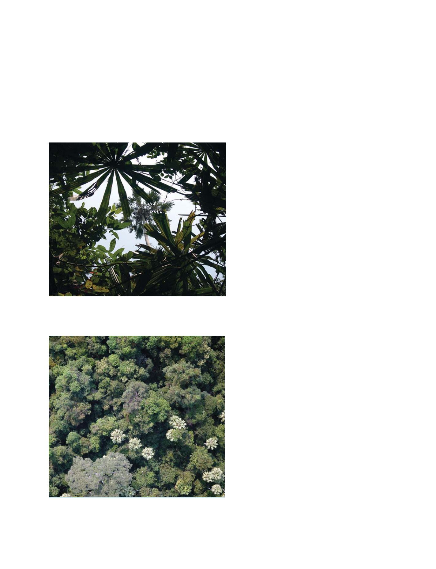
The Global Positioning System coordinates and aerial photographs were
used to guide the field team to the location of specific patches of forest, and
even individual trees
Photo: Douglas Muchoney
While Landsat data are generally acceptable for mapping forests, in this case
they could not be used to locate the sparse palm trees indicative of the wetland
forests. These were readily detectable in aerial photographs
Photo: Eva Galabru
S
OCIETAL
B
ENEFIT
A
REAS
– E
COSYSTEMS