


 120 / 287

[
] 121
O
bserving
, P
redicting
and
P
rOjecting
c
limate
c
OnditiOns
International partnerships: global solutions
through networks
The nature of climate change is such that no individual
organization – or country – has the capability and
resources to fully respond to its challenges independ-
ently. In particular, the need for global information
on key indicators of climate change means that steps
have to be taken to harmonize and integrate the various
observation systems in order to be able to provide the
required consistency of information. EUMETSAT
has responded to this call through strong space
agency collaboration within the Committee for Earth
Observation Satellites (CEOS) and for even longer in
the Coordination Group for Meteorological Satellites
(CGMS) – in which it serves as the permanent secre-
tariat. CGMS members include all the operational
meteorological satellite operators. The CGMS link is
especially beneficial for long-term continuity of data
records due to its members’ global contingency plans for
both geostationary and polar-orbiting satellites. CEOS
has played a vital role in preparing a space agency-wide
response to the GCOS implementation plan, with recur-
ring updates reported to the United Nations Framework
Convention on Climate Change, as well as to the Group
on Earth Observations initiative to establish a Global
Earth Observing System of Systems.
Within Europe, EUMETSAT participates as a
member of the European Meteorological Infrastructure
that includes member state operational meteorological
organizations, the European Centre for Medium-Range
Weather Forecasts and the European Meteorological
Network. Within the context of climate monitoring,
EUMETSAT has the potential to serve as a cornerstone
in the emerging European Climate Infrastructure as
it is developed under the leadership of the European
Commission.
The data sets from the EUMETSAT reprocessing activities
are already used in climate-related studies, like the European
Centre of Medium-Range Weather Forecasts’ reanalysis activi-
ties (www.ecmwf.int/research/era/do/get/Reanalysis_ECMWF).
These activities provide a consistent long-term analysis of the
atmosphere as reported at the 15th Session of the GCOS/World
Climate Research Programme Atmospheric Observation Panel
for Climate meeting in April 2009. Furthermore, the reproc-
essed data sets will enable the derivation of consistent thematic
climate data records from EUMETSAT satellite data, like total
ozone currently generated with data from the GOME-2 instru-
ment that will benefit activities like the WMO/UN Environment
Programme Scientific Assessment of Ozone Depletion.
EUMETSAT’s activities in support of climate monitoring
EUMETSAT’s mission is to deliver cost-efficient operational
satellite data, products and services that satisfy the
meteorological and the climate monitoring data
requirements of its member states.
For climate monitoring, EUMETSAT will provide and maintain
satellite-based climate data records over decades and
with the highest possible level of accuracy, homogeneity,
reliability and stability.
As a first priority, EUMETSAT, at its central facility
and through its climate monitoring SAF, will generate
Fundamental Climate Data Records.
As a second priority, EUMETSAT will generate Thematic
Climate Data Records, making best use of the expertise
available in the EUMETSAT SAFs.
In conducting these activities, EUMETSAT will rely on GCOS
guidance and extensively build on international cooperation
schemes, such as the WMO GSICS and SCOPE-CM activities.
Global mean sea level derived from TOPEX/Poseidon and Jason-1
and -2 data shows an average rise of 3.2mm a year
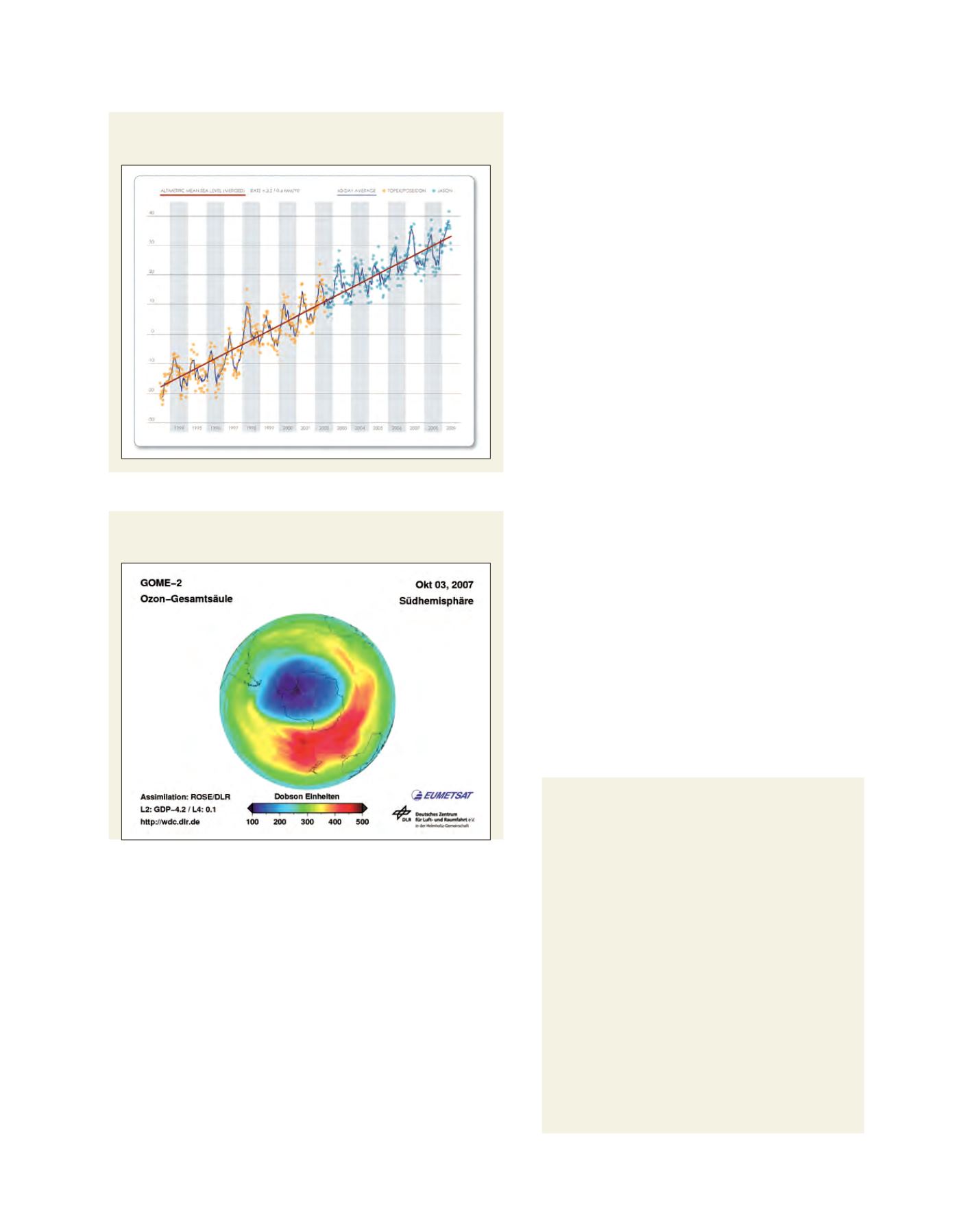
Total ozone in the Southern Hemisphere measured by GOME-2
Source: University of Colorado, LEGOS/CNES
Source: DLR and EUMETSAT