


 122 / 287

[
] 123
O
bserving
, P
redicting
and
P
rOjecting
c
limate
c
OnditiOns
Resources Management of McGill University, CIMH,
and the partner countries of Grenada, Guyana and
Jamaica. This six-year project is funded by the
Canadian International Development Agency.
Drought and the general precipitation status will
be monitored on two scales: regional, encompass-
ing the entire Caribbean basin, and national using
a number of indices and indicators. Indices such as
the Standardized Precipitation Index (SPI),
19
and
deciles
20
will act as indicators of normal or abnormal
rainfall. Other indices can provide information on
normal or abnormal soil moisture (Palmer Drought
Severity index (PDSI), developed by Palmer in
1965;
21
and Crop Moisture Index (CMI) developed
by Palmer in 1968
22
), as well as the status of vege-
tation (Normalised Difference Vegetation Index).
Other indicators can provide information on stream
and river flow, lake and reservoir levels and ground
water quantities.
The final drought and precipitation status of the
region/country will be determined – by consensus – by
a network of persons from different sectors, institutions,
communities and backgrounds embracing the diversity
in definitions and impacts of drought and utilizing the
spectrum of indices and indicators.
Caribbean Basin monitoring
The Caribbean Basin monitoring has been the first
area of focus. It constitutes mainly sea surface, but
Greater Antilles during the months from June to August. Most
models predict a decrease in annual precipitation in the region
of 5 to 15 per cent.
16
It is therefore anticipated that droughts will
become more frequent in the future. On the other hand, there
are indications of more intense rainfall events occurring in the
region since 1950,
17
and this trend is likely to continue with
anthropogenic climate change.
Basic approach of drought and precipitation monitoring
With concerns over drought and excessive precipitation, it was
thought necessary to develop a system that can monitor and fore-
cast such events and thereby allow for the mitigation of their
impacts and provide some means for adaptation in the future.
The Caribbean Drought and Precipitation Monitoring Network
(CDPMN) was launched in January 2009 under the project The
Caribbean Water Initiative (CARIWIN).
18
The goal of CARIWIN
is to increase the capacity of Caribbean countries to deliver equi-
table and sustainable Integrated Water resources Management
(IWRM). It sets out to achieve this by improving the capacity of
the Caribbean Institute for Meteorology and Hydrology (CIMH)
to meet the water management needs of their member states in
a multi-stakeholder environment, in collaboration with regional
and national networks, selected national governments and
community water users. The mission of CIMH is to build national
capacities in meteorology and hydrology. By integrating the
IWRM approach into CIMH training and capacity development
initiatives, the project will have a significant multiplier effect
throughout the Caribbean. CARIWIN, launched in February of
2007, was jointly implemented by the Brace Centre for Water
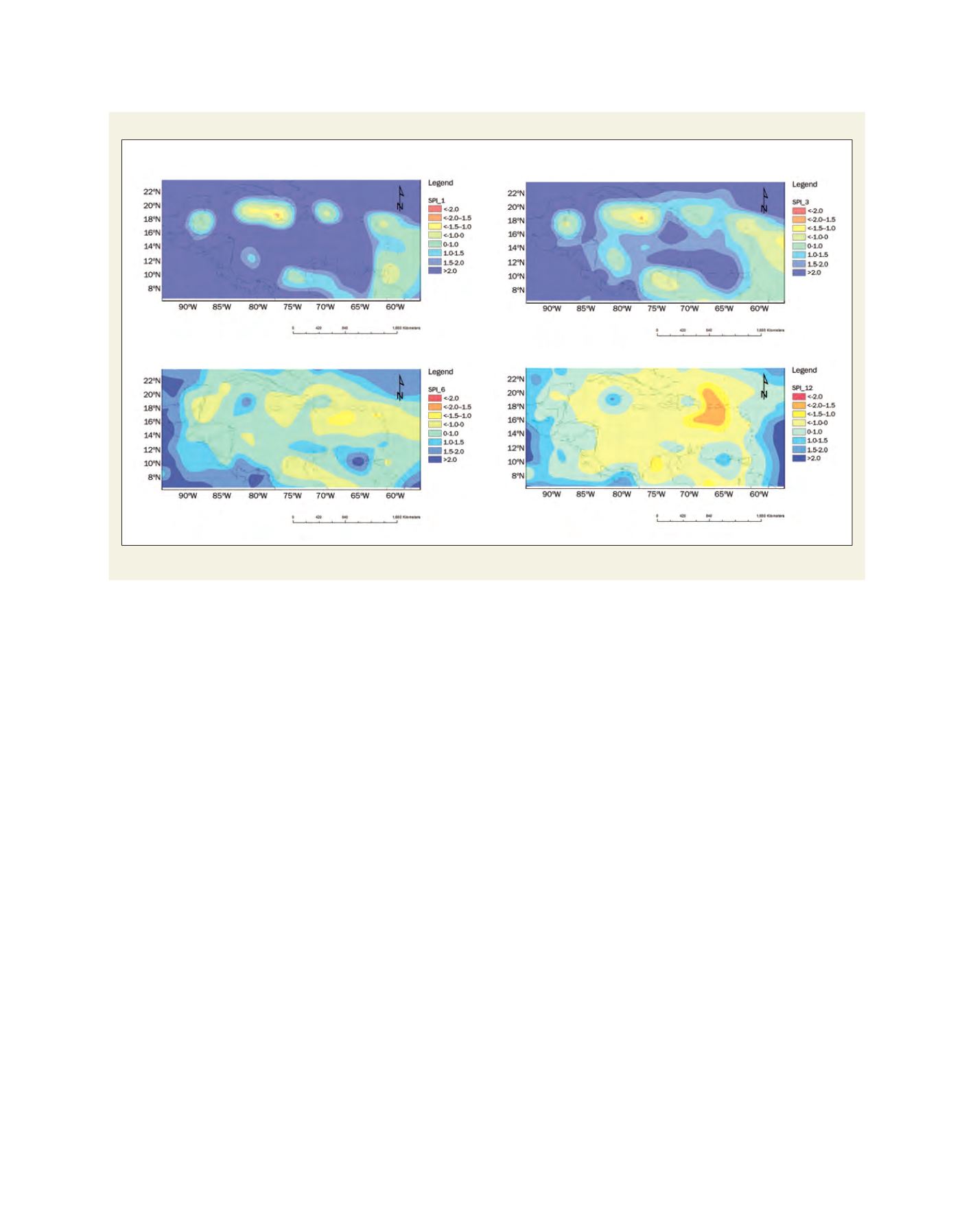
SPI maps for the Caribbean basin
Rainfall readings taken in 1, 3, 6 and 12 month intervals ending April 2009. The drought information can be found at
www.cimh.edu.bb/precipindex.htmlSource: CIMH
SPI for April 2009
SPI for February to April 2009
SPI for November 2008 to April 2009
SPI for May 2008 to April 2009