


 126 / 287

[
] 127
O
bserving
, P
redicting
and
P
rojecting
C
limate
C
onditions
GCOM-W data products will include brightness
temperatures (Tb) and geophysical parameters in
swath form. In addition, spatially and temporally aver-
aged global grid products will be generated. Since the
Tb values are fed into retrieval algorithms to derive all
the geophysical parameters and are directly used in the
numerical data assimilation scheme, well-calibrated
and stable Tb data is necessary. Eight geophysical
parameters will be retrieved and processed as standard
products.
GCOM-C
For this series the four primary parameters will be
atmosphere, ocean, land and cryosphere to best reflect
the human contribution to climate change. In the
atmosphere category measurements will centre on
aerosol and cloud. In order to observe aerosol over land,
three observation methods will be employed, namely:
an ordinary split window method, a near-UV method
and a polarimetry method.
In order to monitor the ocean, low polarization
sensitivity for precise ocean colour observations and
a 250 metre resolution near coastal areas is needed,
because primary productivity depends largely on the
coastal environment. For the land, a 250 metre reso-
lution, as well as multi-angle observation are planned
so that it is possible to precisely evaluate vegetation
and land use change, including primary production
and deforestation. The cryosphere also requires a 250
metre resolution to more accurately estimate loss of
ice sheet, as well as snow physical characteristics. The
aerosol effect on snow is a particularly important issue
that needs to be monitored.
The total number of observation channels has been
reduced compared to the previous GLI sensor by opti-
mizing the objectives in each area. The signal to noise
ratio at standard radiance is over 200 for the visible
and near-infrared channels, while the noise equivalent
temperature difference is lower than 0.2 Kelvin for
thermal infrared (TIR) channels.
To optimize broad spectral range requirements the
system is split into two sensors. For visible and near-
infrared a push-bloom type sensor called the Visible and
Near Infrared Radiometer (VNR) was selected to attain
multi-angle polarimetry and non-polarimetry observa-
tion. To successfully achieve this with a whisk-bloom
type sensor is difficult, as it requires a tilt mechanism
and low polarization sensitivity, which are difficult to
incorporate because of the sensor’s size and catoptric
character. For non-polarimetry observation, the system
has three telescopes to cover a wide area, and for polar-
imetry observation the system has two telescopes. For
shortwave infrared and thermal infrared, the system
has a whisk-bloom type sensor called, simply, Infrared
Scanner (IRS) to take over from the GLI system. Each
VNR and IRS has an on-board calibrator to manage
change.
The SGLI/VNR will cover a relatively large area for
a push-bloom type sensor. Because of this, the obser-
was to improve the reliability and extend the lifespan of the units
from three to five years. As a result, a redundant momentum wheel
and an interface board for two signal processor circuits were added.
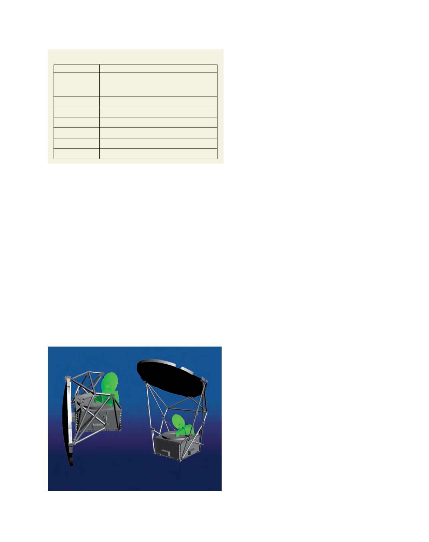
The basic concept of AMSR2 is almost identical to that of the
AMSR-E: conical scanning system with large offset parabolic antenna,
feed horn cluster to realize multi-frequency observation, external cali-
bration with two temperature standards and total-power radiometer
systems. The 2-metre diameter of the antenna, which is larger than
that of AMSR-E, provides a better spatial resolution under the same
orbit altitude of around 700 kilometres. There is also an allowance for
slight underlaps in the 89 gigahertz scans, due to the narrower beam
size of AMSR2 with the same sampling interval of AMSR-E. The C-band
receiver uses additional 7.3 gigahertz channels to mitigate potential
radio frequency interference. An incidence angle of 55 degrees (over
the equator) was selected to keep consistency with AMSR-E. The
observational swath width of 1,450 kilometres, combined with the
selected satellite orbit, will provide almost complete coverage of the
entire Earth’s surface within two days, independently for ascending and
descending observations.
Overview of the AMSR2 sensor unit
Image: JAXA
Instrument
Orbit
Size
Mass
Power
Launch
Design Life
Status
Advanced Microwave Scanning Radiometer-2
Sun-synchronous orbit Altitude: 699.6km (over the
equator) Inclination: 98.186 degrees; Local time of
descending node: 13:30
5.1m (X) * 17.6m (Y) * 5.0m (Z) (on-orbit)
1940kg
Over 4050W
JFY2011 (beginning of CY2012)
5 years
Phase-C study started in JFY2008
Major characteristics of the GCOM-W1 satellite
Source: JAXA