


 174 / 196

[
] 172
understanding of disaster risks across the AusAID port-
folio and support AusAID to better target disaster risk
reduction and humanitarian response activities. This
project sought to broadly identify the characteristics,
frequency, location and potential consequences of rapid-
onset natural hazards including earthquake, tsunami,
landslide, flood, cyclone, wildfire and volcanic eruptions.
Toward an understanding of risk and impact
Disasters are not the inevitable consequence of natural
hazards. A volcanic eruption on an uninhabited Alaskan
island is unlikely to be a disaster whereas the same erup-
tion in the densely populated Asia-Pacific region may
be catastrophic. In order to transform a natural hazard
into a natural disaster, populations need to be exposed
to the hazard. Furthermore, if we dissect the anatomy
of disasters, we find that the impact of the hazard is typi-
cally determined by inherent vulnerabilities within
populations. For example, a magnitude 6 earthquake in
New Zealand is unlikely to cause mass fatalities due to
strict building codes. Yet the same magnitude earth-
quake may lead to many fatalities in the developing
countries of the Asia-Pacific region as building codes, if
available, may not be enforced. To rewrite a familiar
adage, ‘earthquakes don’t kill people, buildings do’.
Thus the ultimate aim of a natural hazard risk assess-
ment is to move beyond an understanding of the hazard
to a more comprehensive understanding of the risks and
potential impacts of hazards on communities. For
example, rather than simply identifying which provinces
have the highest chance of an earthquake or flood, risk
analysis provides information on how many people
would be left homeless by a 1-in-100-year flood or a
magnitude 6.5 earthquake.
A crucial aspect in the assessment of natural disaster
risk is the metric used to define a past disaster and there-
fore the risk of future disasters. Typically, the number of
fatalities is used to classify a disaster. However, this
simplistic metric ignores the number of injured, home-
less and displaced, the requirement for international
humanitarian assistance and the economic impact of a
disaster. In recognition of this we used ‘significantly
impacted population’ as the risk metric in our study.
This deliberately vague term covers death, injury and
displacement, prolonged loss of access to essential
services and/or shelter, and significant damage to agri-
culture, horticulture and industry. Future work to
improve our understanding of natural hazard risk in the
Asia-Pacific region will need to test more specific risk
metrics, particularly those most useful in an interna-
tional development and humanitarian context. For
example, it may be useful to calculate risk in terms of the
number of fatalities and injured, the extent of building
destruction, the period of compromised access to essen-
tial services (water, electricity, communication, health),
the impact on food supply (would the annual harvest
be destroyed?) and/or the effect on the economy.
A particularly useful risk metric, and one touched on
in our study, is the risk of a government’s disaster
ter. Second, natural disasters, particularly relatively infrequent, high-
magnitude natural disasters (for example, the 2004 Indian Ocean
tsunami), require a significant disaster relief and humanitarian
response from aid agencies, which may shift resources away from
other development objectives. For this reason the Australian Agency
for International Development’s (AusAID) strategic direction affirms
that managing and responding to natural disasters should be central
to development planning.
A recent activity undertaken by Geoscience Australia for AusAID
made a preliminary assessment of natural hazard risk across all Asia-
Pacific partner countries.
2
The objective was to gain a better
The convergence of high population density and active
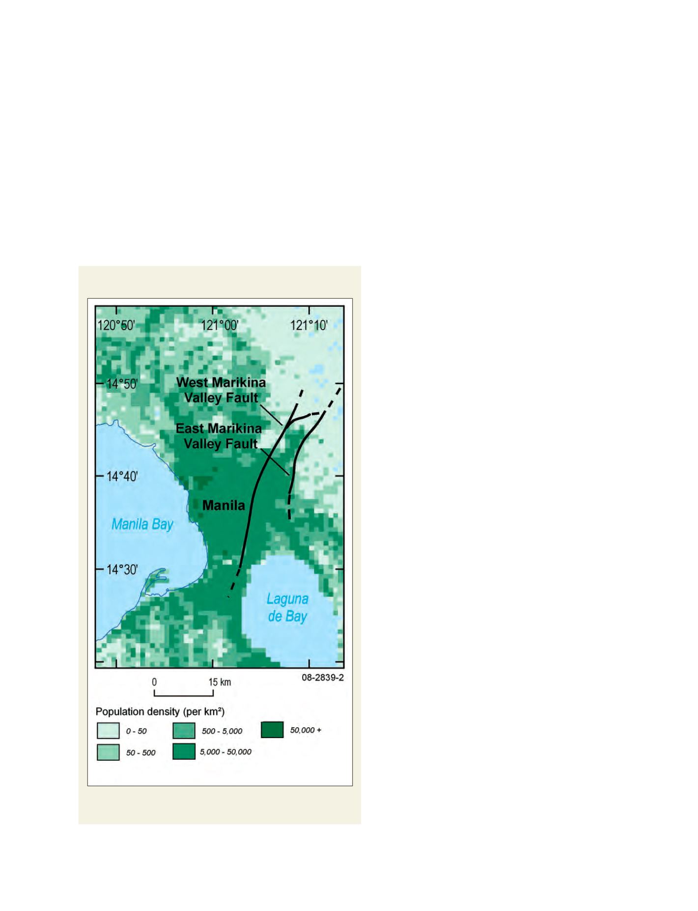
faults in Manila, Philippines
Movement on the Marikina Valley fault could have a devastating impact on
Manila, of a scale determined by the earthquake magnitude and epicentre
Source: Population data from Landscan; fault location from Nelson et al. 2000