


 189 / 196

[
] 187
An approach to disaster management from space
Ryo-ichi Furuta, Tsutomu Yamanokuchi, Riiko Ueno, Nobuhiro Tomiyama,
Tamotsu Igarashi, and Yukio Haruyama, Remote Sensing Technology Center of Japan
T
he technology of satellite remote sensing has the capacity
to monitor natural disasters as well as other objectives
with the advantages of wide-area and frequent observa-
tion capability, a multi-sensor utilization environment, economic
efficiency, and objectivity. The Remote Sensing Technology
Center of Japan (RESTEC) is providing technology for the oper-
ation of Earth observation satellites, Earth observation data
distribution and applications, and training for the utilization of
Earth observation data. Currently, the Japan Aerospace
Exploration Agency (JAXA) has been operating the Advanced
Land Observing Satellite (ALOS) which is the latest Japanese
Earth observation satellite launched in early 2006. RESTEC
supports this operation under the agreement of JAXA.
The mission objectives of ALOS are cartography, disaster monitoring,
regional observation, natural resource monitoring and technology
development for future satellites. Disaster monitoring is currently
drawing attention as an important mission. RESTEC has been apply-
ing the ALOS data to monitor all kinds of natural disasters, as well
as supporting system development for disaster preven-
tion and mitigation in the Asian and Andean region. We
have also held training courses for remote sensing data
users, on a variety of applications including disaster
management. In this paper, we present the latest
RESTEC activities and discuss the effective utilization
of Earth observation data to disaster management.
Example of flood risk management for the Mekong
delta
In the Mekong delta, a large river delta in Vietnam, flood
disasters occur regularly every year. For the mitigation and
reduction of flood disasters, it is important to manage the
river basin. As a tool for river basin monitoring, remote
sensing data is effective from a wide area monitoring
capacity. The utilization of ScanSAR mode (an observa-
tion mode of SAR) is the best solution to monitor a wide
river basin in the Southeast Asian region for three reasons.
First, SAR has the capacity to observe Earth’s surface
under all weather conditions. In Southeast Asia cloud
cover ratio is usually high. Vietnam is an example.
Unfortunately, under the bad weather conditions optical
sensors cannot observe the earth’s surface. Second,
ScanSAR mode is a wide area observation mode and its
observation swath width is normally 100-400 kilome-
tres. Therefore, it is possible to cover almost every area
of interest within one observation timing. Third, it is
possible to observe the target area more frequently than
the normal observation mode without the pointing func-
tion. To reduce the effects of disasters, frequent
observation is important. Many Earth observation
Satellites adopt the 10-50 days revisit orbit. In the case
of ALOS, a 46 days revisit orbit was adopted. However,
utilizing the ScanSAR mode of PALSAR, it can observe
almost the same area every five days.
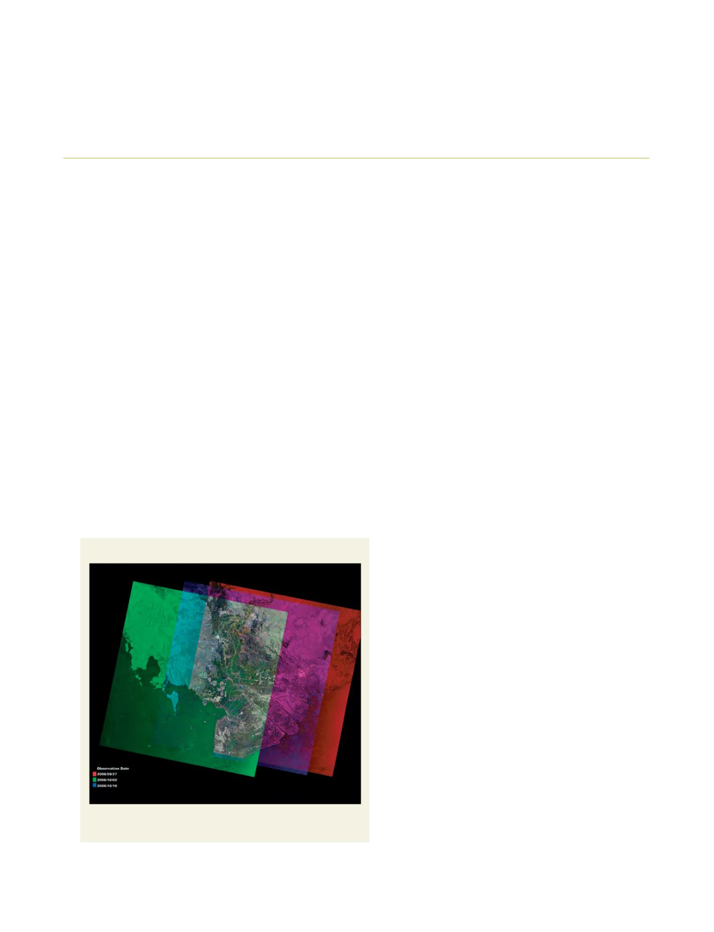
The included figure shows a colour composite image
that is made up from three images at different observation
dates. Data was acquired on 27 September 2006, 2 October
2006, and 16 October 2006 by ALOS PALSAR ScanSAR
mode. The green colour area at the centre of the image
shows that the flooded area was detected from the change
of surface backscattering. We confirmed that the detected
area corresponded to the historical inundation area. The
result was drawn using a simple analysis but we can quickly
pass flood disaster information to the end user. In a prac-
tical test, we sent the image of the flooded area through
Colour composite image of ALOS PALSAR ScanSAR
Source: Remote Sensing Technology Center of Japan
Greenery area at the centre of image shows flooded area from 27 September
2006 to 16 October 2006